
Mt. Rokkoushisan
六角牛山
Tōno-shi, Iwate · Elevation 1,294 m
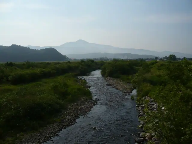
Mt. Rokkōshisan is a 1,294-meter peak straddling Tōno City and Kamaishi City in the central Kitakami Mountains of Iwate Prefecture — its well-shaped conical profile earning it the nickname "Tōno Ko-Fuji." Together with Mt. Hayachine and Mt. Ishigami it forms the Tōno Three Mountains, a goddess-worship trio woven into Yanagita Kunio's *Tōno Monogatari*. The Rokkōshi Shrine, founded in the Daidō era (806–810) by Sakanoue no Tamuramaro according to tradition, stands at the foot with its inner sanctuary on the summit. Three trails — Nukanomae, Nakasawa, and Kuregase — climb the mountain, and the peak is included in the Tōhoku Hyakumeizan, Iwate Hyakumeizan, and Nihon Hyaku-Fuji lists.
Mt. Rokkoushisan at a glance
- Weather: The most settled day in the next 7 days is Mon, November 9: clear, gusts up to 12 m/s. Wed, Nov 4, Fri, Nov 6, Sat, Nov 7, Sun, Nov 8: strong wind (gusts up to 25 m/s).
Mt. Rokkoushisan weather (hourly, 14 days)
Sunrise today 06:03, sunset 16:31
| Tue, 11/3 | Wed, 11/4 | Thu, 11/5 | Fri, 11/6 | Sat, 11/7 | Sun, 11/8 | Mon, 11/9 | Tue, 11/10 | Wed, 11/11 | Thu, 11/12 | Fri, 11/13 | Sat, 11/14 | Sun, 11/15 | Mon, 11/16 | Tue, 11/17 | |||||||||||||||||||||||||||||||||||||||||||||||||||||||||||||||||||||||
|---|---|---|---|---|---|---|---|---|---|---|---|---|---|---|---|---|---|---|---|---|---|---|---|---|---|---|---|---|---|---|---|---|---|---|---|---|---|---|---|---|---|---|---|---|---|---|---|---|---|---|---|---|---|---|---|---|---|---|---|---|---|---|---|---|---|---|---|---|---|---|---|---|---|---|---|---|---|---|---|---|---|---|---|---|---|
| Japan time | 15 | 17 | 19 | 21 | 23 | 1 | 3 | 5 | 7 | 9 | 11 | 13 | 15 | 18 | 21 | 0 | 3 | 6 | 9 | 12 | 15 | 18 | 21 | 0 | 3 | 6 | 9 | 12 | 15 | 18 | 21 | 0 | 3 | 6 | 9 | 12 | 15 | 18 | 21 | 0 | 3 | 6 | 9 | 12 | 15 | 18 | 21 | 0 | 3 | 6 | 9 | 15 | 21 | 3 | 9 | 15 | 21 | 3 | 9 | 15 | 21 | 3 | 9 | 15 | 21 | 3 | 9 | 15 | 21 | 3 | 9 | 15 | 21 | 3 | 9 | 15 | 21 | 3 | 9 | 15 | 21 | 3 | 9 | 15 | |
 |  | | | | |   | | |   | | | | | | |   |   |   | | | | | | | |   |   | | | |   | | |   |   | |   | |   | | | |   | | | |   | | | | |   | | | | |   |   | | | | | | | | | |  | | | | | | | | | | | |   |  | | | ||
| Temperature | °C | 4° | 1° | -1° | -1° | -2° | -3° | 0° | 1° | 2° | 4° | 7° | 8° | 7° | 2° | 1° | 1° | 2° | 4° | 6° | 7° | 7° | 6° | 6° | 6° | 5° | 4° | 8° | 10° | 9° | 5° | 2° | 0° | -2° | -3° | -2° | -1° | -2° | -4° | -4° | -3° | -4° | -4° | -1° | 1° | -1° | -3° | -4° | -3° | -3° | -3° | 0° | 1° | -6° | -6° | -1° | -1° | -2° | -1° | 0° | 0° | -4° | -7° | 0° | 1° | -1° | -1° | 0° | 0° | -7° | -8° | -1° | 3° | -5° | -5° | 3° | 6° | 1° | 2° | 4° | 3° | -4° | -8° | -2° | 2° |
| Precipitation | mm | 2.1 | 4.3 | 5.0 | 4.7 | 1.5 | 0.6 | 1.9 | 2.5 | 0.6 | 0.3 | 0.2 | 0.2 | 0.2 | 0.3 | 0.9 | 1.4 | 0.9 | 0.5 | 0.1 | 6 | 2.6 | 3.1 | 1.5 | 0.5 | 0.3 | 2.3 | 0.8 | 1.2 | 1.4 | |||||||||||||||||||||||||||||||||||||||||||||||||||||||
| New snow | cm | <.1 | 0.2 | 0.6 | 1.2 | 0.9 | 0.5 | <.1 | <.1 | <.1 | 0.3 | <.1 | |||||||||||||||||||||||||||||||||||||||||||||||||||||||||||||||||||||||||
| Snow depth | cm | 0 | 0 | 0 | 0 | 0 | 0 | 0 | 0 | 0 | 0 | 0 | 0 | 0 | 0 | 0 | 0 | 0 | 0 | 0 | 0 | 0 | 0 | 0 | 0 | 0 | 0 | 0 | 0 | 0 | 0 | 0 | 0 | 0 | 0 | 0 | <1 | 1 | 1 | 1 | 1 | <1 | <1 | <1 | <1 | <1 | <1 | <1 | <1 | <1 | <1 | <1 | 0 | 0 | 0 | 0 | 0 | 0 | 0 | 0 | 0 | 0 | 0 | 0 | 0 | 0 | 0 | 0 | 0 | 0 | 0 | 0 | 0 | 0 | 0 | 0 | 0 | 0 | 0 | 0 | 0 | 0 | 0 | 0 | 0 |
| Wind | m/s | 5 | 4 | 3 | 3 | 3 | 2 | 5 | 5 | 4 | 4 | 4 | 3 | 3 | 1 | 1 | 1 | 1 | 2 | 3 | 1 | 2 | 1 | 0 | 0 | 1 | 1 | 4 | 6 | 8 | 8 | 8 | 7 | 7 | 7 | 7 | 8 | 7 | 6 | 7 | 7 | 7 | 7 | 8 | 9 | 9 | 7 | 3 | 4 | 4 | 2 | 4 | 4 | 1 | 1 | 1 | 3 | 2 | 1 | 5 | 6 | 2 | 1 | 3 | 4 | 2 | 2 | 4 | 5 | 1 | 1 | 1 | 3 | 1 | 1 | 1 | 3 | 2 | 1 | 1 | 4 | 3 | 2 | 1 | 3 |
| Wind gusts | m/s | 17 | 14 | 10 | 11 | 10 | 9 | 14 | 15 | 15 | 13 | 12 | 12 | 10 | 7 | 5 | 6 | 7 | 8 | 10 | 9 | 7 | 7 | 4 | 4 | 5 | 7 | 11 | 17 | 21 | 22 | 21 | 22 | 20 | 20 | 20 | 25 | 25 | 20 | 20 | 21 | 20 | 20 | 22 | 25 | 25 | 24 | 20 | 11 | 12 | 11 | 12 | 12 | 10 | 4 | 5 | 9 | 9 | 9 | 15 | 18 | 17 | 6 | 9 | 14 | 12 | 8 | 10 | 13 | 12 | 6 | 5 | 8 | 7 | 5 | 4 | 9 | 8 | 10 | 6 | 13 | 13 | 10 | 8 | 10 |
| Wind dir. | ↓ | ↓ | ↓ | ↓ | ↓ | ↓ | ↓ | ↓ | ↓ | ↓ | ↓ | ↓ | ↓ | ↓ | ↓ | ↓ | ↓ | ↓ | ↓ | ↓ | ↓ | ↓ | ↓ | ↓ | ↓ | ↓ | ↓ | ↓ | ↓ | ↓ | ↓ | ↓ | ↓ | ↓ | ↓ | ↓ | ↓ | ↓ | ↓ | ↓ | ↓ | ↓ | ↓ | ↓ | ↓ | ↓ | ↓ | ↓ | ↓ | ↓ | ↓ | ↓ | ↓ | ↓ | ↓ | ↓ | ↓ | ↓ | ↓ | ↓ | ↓ | ↓ | ↓ | ↓ | ↓ | ↓ | ↓ | ↓ | ↓ | ↓ | ↓ | ↓ | ↓ | ↓ | ↓ | ↓ | ↓ | ↓ | ↓ | ↓ | ↓ | ↓ | ↓ | ↓ | |
Lists that include Mt. Rokkoushisan
100 Fujis of Japan · Tohoku 100 Famous Mountains · Iwate 100 Famous Mountains · Tono 3 Mountains · Elevations of 1003 Mountains of Japan · 1000 Mountains of Japan
Mt. Rokkoushisan facts
- Also known as
- 遠野小富士
- Elevation
- 1,294 m
- Location
- Tōno-shi, Iwate
39.318338, 141.650194 - Website
- iwatetabi.jp
- Wikipedia
- ja.wikipedia.org