
Mt. Ochi
越知山
Echizen, Fukui / Fukui, Fukui · Elevation 613 m
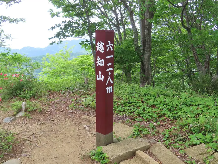
Mt. Ochi (Ochisan, 612.8 m) rises on the boundary between Fukui City and Echizen Town in Niu District, Fukui Prefecture, and is counted among the "Five Sacred Mountains of Echizen" alongside Hakusan, Hino-yama, Monju-yama, and Zaō-san. One of the oldest Shugendō spiritual centres in the Hokuriku region, it is associated with the monk Taichō Daishi, who is said to have trained here from childhood before opening Hakusan. Ochi Shrine — the former Ochi-san Sanjo-Daigongen — sits on the summit with its main hall, inner sanctum, and Daishi-dō. The peak is also one of the "100 Sacred Mountains of Japan".
Mt. Ochi at a glance
- Weather: The most settled day in the next 7 days is Wed, November 4: clear, gusts up to 9 m/s.
- Route: The shortest is Mount Ochi Return by Taicho's Ascetic Path from Ogawa: about 6 h 3 min, 10.1 km, about 830 m of climbing.
Mt. Ochi weather (hourly, 14 days)
Sunrise today 06:20, sunset 16:59
| Tue, 11/3 | Wed, 11/4 | Thu, 11/5 | Fri, 11/6 | Sat, 11/7 | Sun, 11/8 | Mon, 11/9 | Tue, 11/10 | Wed, 11/11 | Thu, 11/12 | Fri, 11/13 | Sat, 11/14 | Sun, 11/15 | Mon, 11/16 | Tue, 11/17 | |||||||||||||||||||||||||||||||||||||||||||||||||||||||||||||||||||||||
|---|---|---|---|---|---|---|---|---|---|---|---|---|---|---|---|---|---|---|---|---|---|---|---|---|---|---|---|---|---|---|---|---|---|---|---|---|---|---|---|---|---|---|---|---|---|---|---|---|---|---|---|---|---|---|---|---|---|---|---|---|---|---|---|---|---|---|---|---|---|---|---|---|---|---|---|---|---|---|---|---|---|---|---|---|---|
| Japan time | 15 | 17 | 19 | 21 | 23 | 1 | 3 | 5 | 7 | 9 | 11 | 13 | 15 | 18 | 21 | 0 | 3 | 6 | 9 | 12 | 15 | 18 | 21 | 0 | 3 | 6 | 9 | 12 | 15 | 18 | 21 | 0 | 3 | 6 | 9 | 12 | 15 | 18 | 21 | 0 | 3 | 6 | 9 | 12 | 15 | 18 | 21 | 0 | 3 | 6 | 9 | 15 | 21 | 3 | 9 | 15 | 21 | 3 | 9 | 15 | 21 | 3 | 9 | 15 | 21 | 3 | 9 | 15 | 21 | 3 | 9 | 15 | 21 | 3 | 9 | 15 | 21 | 3 | 9 | 15 | 21 | 3 | 9 | 15 | |
  |   | | | | | |  | |  | | | |   | |   |   | |   | |   | | | | | | | | |   | | | | | | | | | | | | |   |   | |   | | | | | | | | | | | | |   | | | | | | | | | | |  | | | | | | | | | | | | | | | ||
| Temperature | °C | 15° | 12° | 10° | 9° | 8° | 7° | 7° | 6° | 7° | 12° | 15° | 16° | 16° | 11° | 11° | 10° | 9° | 9° | 11° | 17° | 16° | 14° | 13° | 12° | 12° | 11° | 15° | 17° | 15° | 12° | 11° | 9° | 8° | 7° | 8° | 10° | 10° | 8° | 7° | 7° | 7° | 6° | 9° | 10° | 10° | 9° | 8° | 7° | 6° | 6° | 10° | 12° | 6° | 4° | 11° | 11° | 8° | 7° | 9° | 10° | 8° | 5° | 8° | 11° | 7° | 7° | 10° | 10° | 6° | 2° | 8° | 13° | 5° | 8° | 12° | 13° | 12° | 13° | 13° | 10° | 8° | 6° | 8° | 10° |
| Precipitation | mm | 0.1 | 1.9 | 1.1 | 2.5 | 0.1 | 0.9 | 0.9 | 4.8 | 7 | 0.4 | 1.0 | 0.8 | 0.3 | 0.2 | 0.1 | 0.8 | 0.9 | 0.9 | 0.5 | 0.2 | 0.7 | 0.3 | 2.3 | 4.1 | 1.6 | 0.4 | 0.2 | 0.4 | 3.7 | 1.8 | 2.0 | 5 | 7 | 3.7 | 2.1 | 0.3 | ||||||||||||||||||||||||||||||||||||||||||||||||
| New snow | cm | ||||||||||||||||||||||||||||||||||||||||||||||||||||||||||||||||||||||||||||||||||||
| Snow depth | cm | 0 | 0 | 0 | 0 | 0 | 0 | 0 | 0 | 0 | 0 | 0 | 0 | 0 | 0 | 0 | 0 | 0 | 0 | 0 | 0 | 0 | 0 | 0 | 0 | 0 | 0 | 0 | 0 | 0 | 0 | 0 | 0 | 0 | 0 | 0 | 0 | 0 | 0 | 0 | 0 | 0 | 0 | 0 | 0 | 0 | 0 | 0 | 0 | 0 | 0 | 0 | 0 | 0 | 0 | 0 | 0 | 0 | 0 | 0 | 0 | 0 | 0 | 0 | 0 | 0 | 0 | 0 | 0 | 0 | 0 | 0 | 0 | 0 | 0 | 0 | 0 | 0 | 0 | 0 | 0 | 0 | 0 | 0 | 0 |
| Wind | m/s | 4 | 3 | 3 | 3 | 2 | 1 | 2 | 2 | 2 | 3 | 3 | 2 | 1 | 1 | 0 | 1 | 1 | 1 | 1 | 0 | 1 | 1 | 1 | 1 | 1 | 1 | 2 | 6 | 5 | 4 | 5 | 6 | 5 | 3 | 4 | 5 | 5 | 4 | 2 | 1 | 1 | 1 | 3 | 3 | 4 | 3 | 3 | 1 | 1 | 0 | 1 | 2 | 2 | 1 | 2 | 5 | 5 | 6 | 7 | 6 | 3 | 1 | 1 | 2 | 2 | 1 | 6 | 6 | 2 | 1 | 1 | 1 | 2 | 2 | 2 | 3 | 2 | 3 | 4 | 8 | 5 | 3 | 4 | 4 |
| Wind gusts | m/s | 11 | 10 | 6 | 6 | 6 | 4 | 4 | 5 | 6 | 7 | 9 | 8 | 6 | 3 | 3 | 3 | 4 | 3 | 5 | 4 | 5 | 4 | 3 | 5 | 7 | 5 | 8 | 14 | 14 | 13 | 10 | 12 | 12 | 11 | 12 | 13 | 13 | 11 | 8 | 6 | 5 | 5 | 7 | 9 | 10 | 9 | 8 | 6 | 4 | 3 | 3 | 8 | 7 | 5 | 6 | 13 | 13 | 17 | 16 | 17 | 14 | 7 | 4 | 6 | 5 | 7 | 13 | 14 | 13 | 6 | 5 | 6 | 5 | 6 | 6 | 9 | 9 | 11 | 10 | 17 | 17 | 12 | 10 | 10 |
| Wind dir. | ↓ | ↓ | ↓ | ↓ | ↓ | ↓ | ↓ | ↓ | ↓ | ↓ | ↓ | ↓ | ↓ | ↓ | ↓ | ↓ | ↓ | ↓ | ↓ | ↓ | ↓ | ↓ | ↓ | ↓ | ↓ | ↓ | ↓ | ↓ | ↓ | ↓ | ↓ | ↓ | ↓ | ↓ | ↓ | ↓ | ↓ | ↓ | ↓ | ↓ | ↓ | ↓ | ↓ | ↓ | ↓ | ↓ | ↓ | ↓ | ↓ | ↓ | ↓ | ↓ | ↓ | ↓ | ↓ | ↓ | ↓ | ↓ | ↓ | ↓ | ↓ | ↓ | ↓ | ↓ | ↓ | ↓ | ↓ | ↓ | ↓ | ↓ | ↓ | ↓ | ↓ | ↓ | ↓ | ↓ | ↓ | ↓ | ↓ | ↓ | ↓ | ↓ | ↓ | ↓ | |
Mt. Ochi hiking routes
Hiking times are estimates calculated from the terrain.
Huts, campsites and lodging near Mt. Ochi
Campsites
- ガラガラ山キャンプ場
Mt. Ochi facts
- Elevation
- 613 m
- Location
- Echizen, Fukui / Fukui, Fukui
35.999917, 136.031985 - Website
- www.fuku-e.com
- Wikipedia
- ja.wikipedia.org