
Mt. Musadake
武佐岳
Nakashibetsu, Hokkaido · Elevation 1,006 m
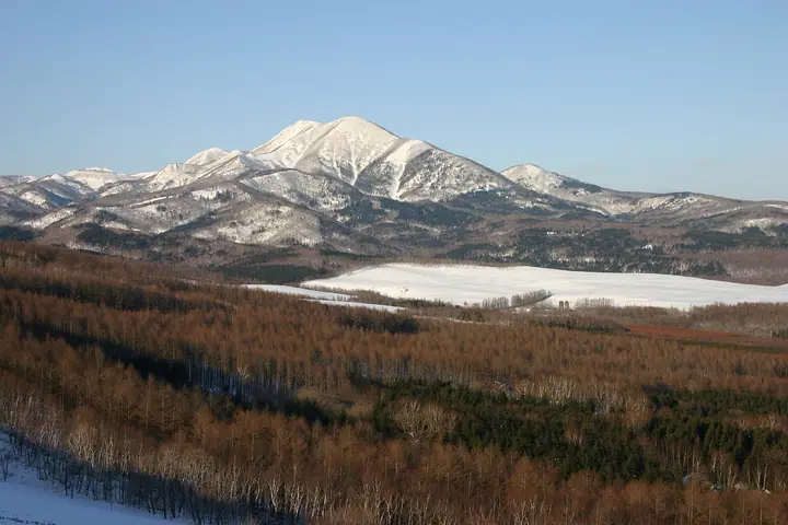
Mt. Musadake is a 1,005-meter freestanding peak in northern Nakashibetsu Town, Shibetsu District, Hokkaido, treated as a symbol of the town and celebrated in local songs. An unpaved forest road leads from Kami-Musa to the trailhead, from where a route of about 5.6 km and 2.5 hours reaches the summit by way of the volunteer-maintained Ikoi-no-sawa shelter. The summit overlooks the grid windbreaks of the Konsen Plateau, the Notsuke Peninsula, Kunashir Island, and the Shiretoko range. The official mountain opening (yamabiraki) is held on the second Sunday of June, and the peak is included in the Hokkaido Hyakumeizan list.
Mt. Musadake at a glance
- Weather: The most settled day in the next 7 days is Mon, November 9: clear, gusts up to 13 m/s. Wed, Nov 4, Sat, Nov 7, Sun, Nov 8: strong wind (gusts up to 23 m/s).
Mt. Musadake weather (hourly, 14 days)
Sunrise today 05:58, sunset 16:10
| Tue, 11/3 | Wed, 11/4 | Thu, 11/5 | Fri, 11/6 | Sat, 11/7 | Sun, 11/8 | Mon, 11/9 | Tue, 11/10 | Wed, 11/11 | Thu, 11/12 | Fri, 11/13 | Sat, 11/14 | Sun, 11/15 | Mon, 11/16 | Tue, 11/17 | |||||||||||||||||||||||||||||||||||||||||||||||||||||||||||||||||||||||
|---|---|---|---|---|---|---|---|---|---|---|---|---|---|---|---|---|---|---|---|---|---|---|---|---|---|---|---|---|---|---|---|---|---|---|---|---|---|---|---|---|---|---|---|---|---|---|---|---|---|---|---|---|---|---|---|---|---|---|---|---|---|---|---|---|---|---|---|---|---|---|---|---|---|---|---|---|---|---|---|---|---|---|---|---|---|
| Japan time | 15 | 17 | 19 | 21 | 23 | 1 | 3 | 5 | 7 | 9 | 11 | 13 | 15 | 18 | 21 | 0 | 3 | 6 | 9 | 12 | 15 | 18 | 21 | 0 | 3 | 6 | 9 | 12 | 15 | 18 | 21 | 0 | 3 | 6 | 9 | 12 | 15 | 18 | 21 | 0 | 3 | 6 | 9 | 12 | 15 | 18 | 21 | 0 | 3 | 6 | 9 | 15 | 21 | 3 | 9 | 15 | 21 | 3 | 9 | 15 | 21 | 3 | 9 | 15 | 21 | 3 | 9 | 15 | 21 | 3 | 9 | 15 | 21 | 3 | 9 | 15 | 21 | 3 | 9 | 15 | 21 | 3 | 9 | 15 | |
 |   | |  | | | |   | |   |   | | |  | | | | | | |   |   |   | | | |   | | | | | | | | | | | | | | | | | | | | | | |   | | | | | | | | |   | | | | |   |   |   |   | |   | | | |  | | | | |   | |   |   | | | | ||
| Temperature | °C | -1° | -3° | -3° | -4° | -4° | -6° | -6° | -4° | -2° | 1° | 1° | 1° | 1° | -4° | -3° | -3° | -3° | -2° | 3° | 6° | 5° | 4° | 4° | 4° | 4° | 4° | 4° | 5° | 5° | 5° | 5° | 0° | -2° | -4° | -2° | 0° | -1° | -5° | -5° | -5° | -6° | -6° | -3° | -2° | -3° | -4° | -4° | -5° | -6° | -7° | -2° | -2° | -6° | -7° | -3° | -3° | -7° | -5° | -3° | -2° | -4° | -6° | -1° | -1° | -4° | -5° | -5° | -4° | -6° | -4° | -3° | -3° | -6° | -5° | 0° | 2° | 1° | 0° | 1° | -2° | -4° | -5° | -4° | -3° |
| Precipitation | mm | 7 | 6 | 0.6 | 2.6 | 0.3 | 1.1 | 1.1 | 0.1 | 0.4 | 0.1 | 0.1 | 0.2 | 0.7 | 0.4 | 0.3 | 1.2 | 1.4 | 1.7 | 2.0 | 2.1 | 1.1 | 0.1 | ||||||||||||||||||||||||||||||||||||||||||||||||||||||||||||||
| New snow | cm | 0.4 | <.1 | <.1 | 0.1 | 0.1 | 0.2 | 0.7 | 0.4 | 0.3 | <.1 | 0.6 | 1.2 | 2.1 | 1.1 | 0.1 | |||||||||||||||||||||||||||||||||||||||||||||||||||||||||||||||||||||
| Snow depth | cm | 0 | 0 | 0 | 0 | 0 | 0 | 0 | 0 | 0 | 0 | 0 | 0 | 0 | 0 | 0 | 0 | 0 | 0 | 0 | 0 | 0 | 0 | 0 | 0 | 0 | 0 | 0 | 0 | 0 | 0 | 0 | 0 | 0 | 0 | 0 | 0 | 0 | 0 | 0 | 0 | 0 | 0 | 0 | 0 | 0 | 0 | 0 | 0 | 0 | 0 | 0 | 0 | 0 | 0 | 0 | 0 | 0 | 0 | 0 | 0 | 0 | 0 | 0 | 0 | 0 | <1 | <1 | <1 | <1 | <1 | 1 | <1 | <1 | <1 | <1 | <1 | <1 | <1 | 0 | <1 | <1 | 2 | 3 | 3 |
| Wind | m/s | 5 | 5 | 4 | 4 | 3 | 2 | 3 | 4 | 4 | 7 | 8 | 5 | 3 | 2 | 1 | 3 | 1 | 3 | 3 | 3 | 2 | 0 | 0 | 0 | 1 | 1 | 2 | 2 | 2 | 2 | 3 | 5 | 6 | 4 | 5 | 7 | 6 | 4 | 3 | 3 | 4 | 4 | 8 | 9 | 8 | 9 | 8 | 6 | 4 | 3 | 5 | 3 | 4 | 4 | 3 | 2 | 1 | 2 | 3 | 2 | 1 | 2 | 0 | 1 | 4 | 4 | 6 | 4 | 7 | 7 | 6 | 2 | 2 | 2 | 4 | 3 | 4 | 3 | 2 | 6 | 6 | 3 | 5 | 3 |
| Wind gusts | m/s | 13 | 12 | 12 | 12 | 11 | 8 | 7 | 9 | 10 | 17 | 19 | 18 | 13 | 7 | 5 | 8 | 7 | 8 | 10 | 10 | 10 | 6 | 4 | 4 | 4 | 4 | 5 | 6 | 6 | 5 | 7 | 12 | 13 | 14 | 13 | 18 | 19 | 14 | 10 | 8 | 10 | 12 | 19 | 21 | 23 | 22 | 22 | 20 | 15 | 10 | 12 | 13 | 10 | 11 | 9 | 8 | 5 | 4 | 8 | 9 | 5 | 4 | 4 | 6 | 8 | 10 | 16 | 16 | 20 | 19 | 17 | 14 | 7 | 5 | 8 | 9 | 9 | 10 | 8 | 15 | 15 | 15 | 12 | 12 |
| Wind dir. | ↓ | ↓ | ↓ | ↓ | ↓ | ↓ | ↓ | ↓ | ↓ | ↓ | ↓ | ↓ | ↓ | ↓ | ↓ | ↓ | ↓ | ↓ | ↓ | ↓ | ↓ | ↓ | ↓ | ↓ | ↓ | ↓ | ↓ | ↓ | ↓ | ↓ | ↓ | ↓ | ↓ | ↓ | ↓ | ↓ | ↓ | ↓ | ↓ | ↓ | ↓ | ↓ | ↓ | ↓ | ↓ | ↓ | ↓ | ↓ | ↓ | ↓ | ↓ | ↓ | ↓ | ↓ | ↓ | ↓ | ↓ | ↓ | ↓ | ↓ | ↓ | ↓ | ↓ | ↓ | ↓ | ↓ | ↓ | ↓ | ↓ | ↓ | ↓ | ↓ | ↓ | ↓ | ↓ | ↓ | ↓ | ↓ | ↓ | ↓ | ↓ | ↓ | ↓ | ↓ | |
Huts, campsites and lodging near Mt. Musadake
Mountain huts
- 武佐岳憩清荘
Mt. Musadake facts
- Elevation
- 1,006 m
- Location
- Nakashibetsu, Hokkaido
43.677801, 144.881811 - Website
- www.nakashibetsu.jp
- Trail Map
- www.nakashibetsu.jp (PDF)
- Wikipedia
- ja.wikipedia.org