
Mt. Minobusan
身延山
Minobu, Yamanashi · Elevation 1,153 m
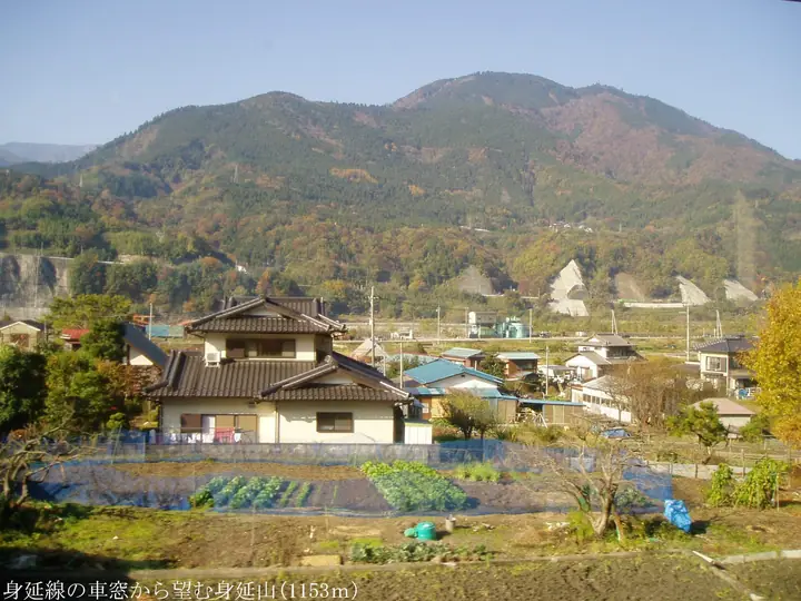
Minobusan is a 1,153 m peak on the boundary of Minobu and Hayakawa towns, Minamikoma District, Yamanashi Prefecture — the sacred mountain of Kuon-ji, head temple of the Nichiren sect, and one of Japan's three great Buddhist holy mountains. Nichiren entered Minobu in 1274 and climbed to the summit to gaze toward his birthplace; the Okuno-in Shishin-kaku at the top commands views of Mt. Fuji, the South Alps, and Suruga Bay. The 11.5 km, 5 hour 40 minute pilgrim route from the Kuon-ji Sanmon up the Bodaitei stairs is one of the "Yamanashi Hiking 100" historical courses, complemented by the 763 m-vertical Minobusan Ropeway.
Mt. Minobusan at a glance
- Weather: The most settled day in the next 7 days is Sat, November 7: clear, gusts up to 9 m/s.
- Route: The shortest is Mount Minobu Kuonji and Okunoin Loop via the East and West Courses: about 5 h 36 min, 12.4 km, about 920 m of climbing.
Mt. Minobusan weather (hourly, 14 days)
Sunrise today 06:10, sunset 16:50
| Tue, 11/3 | Wed, 11/4 | Thu, 11/5 | Fri, 11/6 | Sat, 11/7 | Sun, 11/8 | Mon, 11/9 | Tue, 11/10 | Wed, 11/11 | Thu, 11/12 | Fri, 11/13 | Sat, 11/14 | Sun, 11/15 | Mon, 11/16 | Tue, 11/17 | |||||||||||||||||||||||||||||||||||||||||||||||||||||||||||||||||||||||
|---|---|---|---|---|---|---|---|---|---|---|---|---|---|---|---|---|---|---|---|---|---|---|---|---|---|---|---|---|---|---|---|---|---|---|---|---|---|---|---|---|---|---|---|---|---|---|---|---|---|---|---|---|---|---|---|---|---|---|---|---|---|---|---|---|---|---|---|---|---|---|---|---|---|---|---|---|---|---|---|---|---|---|---|---|---|
| Japan time | 21 | 23 | 1 | 3 | 5 | 7 | 9 | 11 | 13 | 15 | 17 | 19 | 21 | 0 | 3 | 6 | 9 | 12 | 15 | 18 | 21 | 0 | 3 | 6 | 9 | 12 | 15 | 18 | 21 | 0 | 3 | 6 | 9 | 12 | 15 | 18 | 21 | 0 | 3 | 6 | 9 | 12 | 15 | 18 | 21 | 0 | 3 | 6 | 9 | 12 | 15 | 21 | 3 | 9 | 15 | 21 | 3 | 9 | 15 | 21 | 3 | 9 | 15 | 21 | 3 | 9 | 15 | 21 | 3 | 9 | 15 | 21 | 3 | 9 | 15 | 21 | 3 | 9 | 15 | 21 | 3 | 9 | 15 | 21 | |
  |   |   | | |   |   | |   | | | | | | |   |   | | |   | | | | |  |   | |  | | | | | |   | | | |   | | | | | | | | | | | | | | | | | | | | | |   | | | | | | | | | | | | | | | | | | | | | | | | | ||
| Temperature | °C | 7° | 6° | 6° | 4° | 5° | 6° | 8° | 9° | 9° | 9° | 7° | 7° | 7° | 7° | 7° | 7° | 10° | 14° | 12° | 10° | 8° | 7° | 8° | 8° | 15° | 17° | 15° | 10° | 6° | 4° | 3° | 4° | 10° | 12° | 11° | 4° | 5° | 5° | 5° | 5° | 8° | 9° | 9° | 6° | 5° | 5° | 6° | 6° | 7° | 8° | 8° | 5° | 4° | 7° | 8° | 3° | 2° | 4° | 8° | 1° | 0° | 6° | 7° | 5° | 3° | 8° | 9° | 4° | 4° | 4° | 6° | 5° | 3° | 8° | 9° | 7° | 8° | 11° | 16° | 7° | 6° | 5° | 6° | 4° |
| Precipitation | mm | 0.4 | 0.4 | 0.3 | 1.1 | 0.7 | 1.4 | 11 | 15 | 7 | 0.2 | 0.1 | 0.2 | 0.1 | 0.1 | 0.1 | 0.2 | 1.2 | 1.0 | 0.8 | 0.1 | 0.7 | 0.2 | 0.3 | 0.4 | 0.3 | 0.5 | 0.6 | 0.1 | 0.7 | 0.1 | 0.2 | 0.4 | 14 | 24 | 1.6 | 2.9 | 0.4 | 1.0 | ||||||||||||||||||||||||||||||||||||||||||||||
| New snow | cm | ||||||||||||||||||||||||||||||||||||||||||||||||||||||||||||||||||||||||||||||||||||
| Snow depth | cm | 0 | 0 | 0 | 0 | 0 | 0 | 0 | 0 | 0 | 0 | 0 | 0 | 0 | 0 | 0 | 0 | 0 | 0 | 0 | 0 | 0 | 0 | 0 | 0 | 0 | 0 | 0 | 0 | 0 | 0 | 0 | 0 | 0 | 0 | 0 | 0 | 0 | 0 | 0 | 0 | 0 | 0 | 0 | 0 | 0 | 0 | 0 | 0 | 0 | 0 | 0 | 0 | 0 | 0 | 0 | 0 | 0 | 0 | 0 | 0 | 0 | 0 | 0 | 0 | 0 | 0 | 0 | 0 | 0 | 0 | 0 | 0 | 0 | 0 | 0 | 0 | 0 | 0 | 0 | 0 | 0 | 0 | 0 | 0 |
| Wind | m/s | 2 | 1 | 0 | 1 | 1 | 2 | 1 | 1 | 1 | 1 | 2 | 1 | 2 | 1 | 2 | 2 | 3 | 1 | 2 | 1 | 1 | 1 | 1 | 1 | 1 | 3 | 2 | 0 | 1 | 1 | 1 | 0 | 2 | 3 | 2 | 1 | 1 | 2 | 1 | 1 | 2 | 3 | 4 | 2 | 2 | 1 | 1 | 1 | 2 | 3 | 3 | 2 | 1 | 2 | 4 | 1 | 2 | 2 | 2 | 1 | 1 | 3 | 4 | 1 | 0 | 2 | 1 | 1 | 1 | 1 | 3 | 2 | 1 | 3 | 3 | 1 | 1 | 1 | 1 | 2 | 2 | 2 | 3 | 2 |
| Wind gusts | m/s | 8 | 7 | 5 | 3 | 4 | 6 | 7 | 6 | 6 | 6 | 7 | 7 | 7 | 9 | 9 | 9 | 10 | 10 | 7 | 7 | 6 | 6 | 7 | 7 | 6 | 9 | 10 | 7 | 5 | 5 | 4 | 4 | 7 | 9 | 9 | 7 | 4 | 6 | 6 | 5 | 7 | 10 | 13 | 11 | 7 | 7 | 7 | 5 | 6 | 10 | 11 | 9 | 7 | 6 | 13 | 12 | 6 | 12 | 11 | 8 | 5 | 8 | 14 | 11 | 4 | 9 | 10 | 6 | 3 | 5 | 10 | 9 | 5 | 9 | 12 | 10 | 11 | 7 | 7 | 8 | 6 | 7 | 11 | 10 |
| Wind dir. | ↓ | ↓ | ↓ | ↓ | ↓ | ↓ | ↓ | ↓ | ↓ | ↓ | ↓ | ↓ | ↓ | ↓ | ↓ | ↓ | ↓ | ↓ | ↓ | ↓ | ↓ | ↓ | ↓ | ↓ | ↓ | ↓ | ↓ | ↓ | ↓ | ↓ | ↓ | ↓ | ↓ | ↓ | ↓ | ↓ | ↓ | ↓ | ↓ | ↓ | ↓ | ↓ | ↓ | ↓ | ↓ | ↓ | ↓ | ↓ | ↓ | ↓ | ↓ | ↓ | ↓ | ↓ | ↓ | ↓ | ↓ | ↓ | ↓ | ↓ | ↓ | ↓ | ↓ | ↓ | ↓ | ↓ | ↓ | ↓ | ↓ | ↓ | ↓ | ↓ | ↓ | ↓ | ↓ | ↓ | ↓ | ↓ | ↓ | ↓ | ↓ | ↓ | ↓ | ↓ | |
Mt. Minobusan hiking routes
Hiking times are estimates calculated from the terrain.
Huts, campsites and lodging near Mt. Minobusan
Lodging
- 覚林坊
Lists that include Mt. Minobusan
100 Low Mountains of Japan · Yamanashi 100 Famous Mountains · Elevations of 1003 Mountains of Japan · 1000 Mountains of Japan
Mt. Minobusan facts
- Elevation
- 1,153 m
- Location
- Minobu, Yamanashi
35.397363, 138.416362 - Website
- www.kuonji.jp
- Trail Map
- www.minobusanropeway.co.jp
- Access Information
- yamanashi-hiking100.jp
- Wikipedia
- ja.wikipedia.org