
Mt. Kōno
交野山
Katano, Osaka · Elevation 341 m
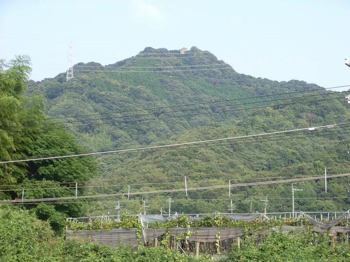
Mt. Kōno is a 341 m peak at the northern end of the Ikoma Mountains in Katano City, Osaka Prefecture. Its summit boulder, Kannon-iwa, is a symbol of the city visible from far away and offers a 360-degree panorama from the Osaka Plain to Mt. Hiei and the Akashi Strait. A Sanskrit character representing Avalokitesvara was carved on the rock in medieval times, and the peak was used as a Shugendō training ground. The sunrise from Kōnosan is one of the Eight Scenic Views of Katano, and together with Mt. Ryuō and Mt. Hatafuri it forms the Katano Sanzan. Maintained trails climb from JR Tsuda or Kawachi-Iwafune stations.
Mt. Kōno at a glance
- Weather: The most settled day in the next 7 days is Thu, November 5: clear, gusts up to 5 m/s.
- Route: The shortest is Hirakata Tsuda Return along the Northern End of the Ikoma Range to Mount Kono and Its Giant Kannon Rock: about 2 h 55 min, 6.4 km, about 340 m of climbing.
Mt. Kōno weather (hourly, 14 days)
Sunrise today 06:19, sunset 17:03
| Tue, 11/3 | Wed, 11/4 | Thu, 11/5 | Fri, 11/6 | Sat, 11/7 | Sun, 11/8 | Mon, 11/9 | Tue, 11/10 | Wed, 11/11 | Thu, 11/12 | Fri, 11/13 | Sat, 11/14 | Sun, 11/15 | Mon, 11/16 | Tue, 11/17 | |||||||||||||||||||||||||||||||||||||||||||||||||||||||||||||||||||||||
|---|---|---|---|---|---|---|---|---|---|---|---|---|---|---|---|---|---|---|---|---|---|---|---|---|---|---|---|---|---|---|---|---|---|---|---|---|---|---|---|---|---|---|---|---|---|---|---|---|---|---|---|---|---|---|---|---|---|---|---|---|---|---|---|---|---|---|---|---|---|---|---|---|---|---|---|---|---|---|---|---|---|---|---|---|---|
| Japan time | 15 | 17 | 19 | 21 | 23 | 1 | 3 | 5 | 7 | 9 | 11 | 13 | 15 | 18 | 21 | 0 | 3 | 6 | 9 | 12 | 15 | 18 | 21 | 0 | 3 | 6 | 9 | 12 | 15 | 18 | 21 | 0 | 3 | 6 | 9 | 12 | 15 | 18 | 21 | 0 | 3 | 6 | 9 | 12 | 15 | 18 | 21 | 0 | 3 | 6 | 9 | 15 | 21 | 3 | 9 | 15 | 21 | 3 | 9 | 15 | 21 | 3 | 9 | 15 | 21 | 3 | 9 | 15 | 21 | 3 | 9 | 15 | 21 | 3 | 9 | 15 | 21 | 3 | 9 | 15 | 21 | 3 | 9 | 15 | |
  |   |   | | |  | | | | | | |   |   |   |   | |   |   |   |  | | | |   | | | | | |  | | | | | | | | | | | | | | | | | | | | | | | | | | | | | |   |  | | | | | | | | | | | | | |   | | | | | | | | | ||
| Temperature | °C | 18° | 14° | 12° | 12° | 11° | 9° | 9° | 8° | 9° | 13° | 16° | 18° | 17° | 15° | 14° | 13° | 14° | 13° | 15° | 17° | 19° | 16° | 15° | 14° | 15° | 14° | 17° | 19° | 19° | 15° | 12° | 10° | 8° | 8° | 11° | 13° | 12° | 9° | 7° | 6° | 5° | 5° | 10° | 13° | 13° | 10° | 10° | 9° | 9° | 9° | 12° | 14° | 10° | 8° | 11° | 15° | 9° | 8° | 10° | 11° | 7° | 5° | 9° | 12° | 8° | 6° | 11° | 12° | 7° | 4° | 9° | 15° | 7° | 6° | 13° | 16° | 12° | 13° | 14° | 16° | 10° | 6° | 9° | 13° |
| Precipitation | mm | 3.9 | 3.5 | 1.1 | 0.6 | 0.2 | 1.0 | 0.5 | 0.7 | 0.2 | 0.1 | 0.3 | 0.4 | 1.3 | 6 | 0.1 | 0.5 | ||||||||||||||||||||||||||||||||||||||||||||||||||||||||||||||||||||
| New snow | cm | ||||||||||||||||||||||||||||||||||||||||||||||||||||||||||||||||||||||||||||||||||||
| Snow depth | cm | 0 | 0 | 0 | 0 | 0 | 0 | 0 | 0 | 0 | 0 | 0 | 0 | 0 | 0 | 0 | 0 | 0 | 0 | 0 | 0 | 0 | 0 | 0 | 0 | 0 | 0 | 0 | 0 | 0 | 0 | 0 | 0 | 0 | 0 | 0 | 0 | 0 | 0 | 0 | 0 | 0 | 0 | 0 | 0 | 0 | 0 | 0 | 0 | 0 | 0 | 0 | 0 | 0 | 0 | 0 | 0 | 0 | 0 | 0 | 0 | 0 | 0 | 0 | 0 | 0 | 0 | 0 | 0 | 0 | 0 | 0 | 0 | 0 | 0 | 0 | 0 | 0 | 0 | 0 | 0 | 0 | 0 | 0 | 0 |
| Wind | m/s | 3 | 3 | 2 | 2 | 1 | 1 | 1 | 0 | 1 | 1 | 2 | 2 | 3 | 3 | 3 | 2 | 4 | 2 | 2 | 2 | 2 | 1 | 1 | 1 | 3 | 1 | 3 | 4 | 4 | 4 | 3 | 3 | 2 | 2 | 3 | 5 | 5 | 3 | 1 | 1 | 1 | 1 | 0 | 2 | 3 | 1 | 0 | 0 | 1 | 1 | 0 | 3 | 0 | 0 | 1 | 3 | 1 | 3 | 2 | 5 | 1 | 1 | 1 | 2 | 2 | 1 | 1 | 5 | 1 | 1 | 1 | 1 | 1 | 1 | 2 | 3 | 1 | 0 | 1 | 5 | 3 | 1 | 1 | 2 |
| Wind gusts | m/s | 6 | 7 | 6 | 4 | 3 | 2 | 2 | 2 | 2 | 3 | 5 | 6 | 7 | 7 | 8 | 7 | 9 | 8 | 5 | 4 | 5 | 4 | 2 | 3 | 6 | 6 | 7 | 10 | 11 | 9 | 8 | 7 | 6 | 5 | 7 | 12 | 12 | 10 | 6 | 2 | 2 | 2 | 3 | 5 | 9 | 7 | 3 | 1 | 1 | 2 | 3 | 6 | 6 | 2 | 4 | 10 | 8 | 8 | 7 | 14 | 13 | 3 | 4 | 6 | 6 | 3 | 3 | 11 | 11 | 2 | 3 | 5 | 3 | 3 | 5 | 7 | 6 | 4 | 4 | 12 | 11 | 7 | 3 | 6 |
| Wind dir. | ↓ | ↓ | ↓ | ↓ | ↓ | ↓ | ↓ | ↓ | ↓ | ↓ | ↓ | ↓ | ↓ | ↓ | ↓ | ↓ | ↓ | ↓ | ↓ | ↓ | ↓ | ↓ | ↓ | ↓ | ↓ | ↓ | ↓ | ↓ | ↓ | ↓ | ↓ | ↓ | ↓ | ↓ | ↓ | ↓ | ↓ | ↓ | ↓ | ↓ | ↓ | ↓ | ↓ | ↓ | ↓ | ↓ | ↓ | ↓ | ↓ | ↓ | ↓ | ↓ | ↓ | ↓ | ↓ | ↓ | ↓ | ↓ | ↓ | ↓ | ↓ | ↓ | ↓ | ↓ | ↓ | ↓ | ↓ | ↓ | ↓ | ↓ | ↓ | ↓ | ↓ | ↓ | ↓ | ↓ | ↓ | ↓ | ↓ | ↓ | ↓ | ↓ | ↓ | ↓ | |
Mt. Kōno hiking routes
Hiking times are estimates calculated from the terrain.
Huts, campsites and lodging near Mt. Kōno
Lodging
- Green Village Katano
- Seminar House #2
- Seminar House #1
- メゾンオータニ
Lists that include Mt. Kōno
Mt. Kōno facts
- Also known as
- 交野三山
- Elevation
- 341 m
- Location
- Katano, Osaka
34.786523, 135.709530 - Website
- www.city.katano.osaka.jp
- Trail Map
- www.city.katano.osaka.jp
- Wikipedia
- ja.wikipedia.org