
Mt. Koganegatake
小金ヶ嶽
Tamba-Sasayama, Hyogo · Elevation 726 m
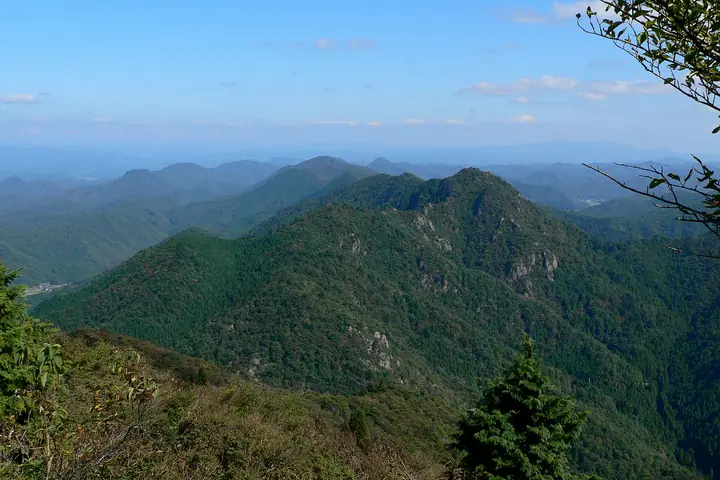
Koganegatake is a 726 m peak in Tambasasayama City, Hyōgo Prefecture, forming the eastern summit of the Taki Range together with Mitake and Nishigatake. The traverse is laced with rocky ledges and chained sections and was historically used as a Tamba Shugendō training ground. The peak lies within Taki Renzan Prefectural Natural Park and appears in the Furusato Hyōgo 100 and other regional selections.
Mt. Koganegatake at a glance
- Weather: The most settled day in the next 7 days is Wed, November 4: clear, gusts up to 9 m/s.
- Route: The shortest is Mount Mitake and Koganegatake Loop: about 5 h 38 min, 9.4 km, about 850 m of climbing.
Mt. Koganegatake weather (hourly, 14 days)
Sunrise today 06:21, sunset 17:04
| Tue, 11/3 | Wed, 11/4 | Thu, 11/5 | Fri, 11/6 | Sat, 11/7 | Sun, 11/8 | Mon, 11/9 | Tue, 11/10 | Wed, 11/11 | Thu, 11/12 | Fri, 11/13 | Sat, 11/14 | Sun, 11/15 | Mon, 11/16 | Tue, 11/17 | |||||||||||||||||||||||||||||||||||||||||||||||||||||||||||||||||||||||
|---|---|---|---|---|---|---|---|---|---|---|---|---|---|---|---|---|---|---|---|---|---|---|---|---|---|---|---|---|---|---|---|---|---|---|---|---|---|---|---|---|---|---|---|---|---|---|---|---|---|---|---|---|---|---|---|---|---|---|---|---|---|---|---|---|---|---|---|---|---|---|---|---|---|---|---|---|---|---|---|---|---|---|---|---|---|
| Japan time | 15 | 17 | 19 | 21 | 23 | 1 | 3 | 5 | 7 | 9 | 11 | 13 | 15 | 18 | 21 | 0 | 3 | 6 | 9 | 12 | 15 | 18 | 21 | 0 | 3 | 6 | 9 | 12 | 15 | 18 | 21 | 0 | 3 | 6 | 9 | 12 | 15 | 18 | 21 | 0 | 3 | 6 | 9 | 12 | 15 | 18 | 21 | 0 | 3 | 6 | 9 | 15 | 21 | 3 | 9 | 15 | 21 | 3 | 9 | 15 | 21 | 3 | 9 | 15 | 21 | 3 | 9 | 15 | 21 | 3 | 9 | 15 | 21 | 3 | 9 | 15 | 21 | 3 | 9 | 15 | 21 | 3 | 9 | 15 | |
  |   |   | | | | | | |  | |   | |   | |   | |   |   | | |   | | | | | |   | | | | | |  | | | | |   | | | | | | | | | | | | | |   | | | | | | | | |  | | | | | | | | | | | | |   | | | | | | | | | | ||
| Temperature | °C | 12° | 10° | 8° | 7° | 7° | 7° | 7° | 6° | 7° | 12° | 14° | 15° | 13° | 10° | 11° | 10° | 10° | 10° | 11° | 16° | 17° | 13° | 12° | 12° | 11° | 10° | 13° | 16° | 15° | 10° | 8° | 7° | 6° | 5° | 8° | 10° | 9° | 6° | 4° | 5° | 4° | 4° | 9° | 11° | 11° | 8° | 7° | 7° | 7° | 7° | 10° | 11° | 5° | 4° | 9° | 12° | 5° | 5° | 8° | 8° | 5° | 2° | 8° | 11° | 5° | 4° | 8° | 9° | 4° | 3° | 8° | 13° | 5° | 7° | 12° | 12° | 11° | 11° | 12° | 11° | 6° | 3° | 7° | 9° |
| Precipitation | mm | 0.2 | 1.0 | 1.3 | 2.9 | 1.5 | 0.4 | 0.7 | 0.2 | 0.9 | 0.1 | 0.3 | 0.1 | 0.7 | 0.7 | 0.2 | 0.1 | 0.3 | 1.1 | 7 | 2.2 | 0.5 | 1.6 | 0.5 | |||||||||||||||||||||||||||||||||||||||||||||||||||||||||||||
| New snow | cm | ||||||||||||||||||||||||||||||||||||||||||||||||||||||||||||||||||||||||||||||||||||
| Snow depth | cm | 0 | 0 | 0 | 0 | 0 | 0 | 0 | 0 | 0 | 0 | 0 | 0 | 0 | 0 | 0 | 0 | 0 | 0 | 0 | 0 | 0 | 0 | 0 | 0 | 0 | 0 | 0 | 0 | 0 | 0 | 0 | 0 | 0 | 0 | 0 | 0 | 0 | 0 | 0 | 0 | 0 | 0 | 0 | 0 | 0 | 0 | 0 | 0 | 0 | 0 | 0 | 0 | 0 | 0 | 0 | 0 | 0 | 0 | 0 | 0 | 0 | 0 | 0 | 0 | 0 | 0 | 0 | 0 | 0 | 0 | 0 | 0 | 0 | 0 | 0 | 0 | 0 | 0 | 0 | 0 | 0 | 0 | 0 | 0 |
| Wind | m/s | 4 | 3 | 3 | 2 | 2 | 2 | 3 | 3 | 2 | 3 | 4 | 3 | 3 | 2 | 1 | 5 | 2 | 1 | 1 | 1 | 1 | 1 | 1 | 1 | 3 | 1 | 2 | 4 | 5 | 4 | 4 | 4 | 4 | 4 | 6 | 6 | 6 | 3 | 2 | 2 | 2 | 1 | 2 | 5 | 4 | 2 | 1 | 0 | 0 | 0 | 1 | 4 | 1 | 1 | 4 | 4 | 2 | 5 | 7 | 6 | 3 | 1 | 1 | 2 | 3 | 2 | 5 | 6 | 3 | 2 | 1 | 2 | 3 | 3 | 3 | 5 | 4 | 2 | 4 | 7 | 6 | 3 | 5 | 4 |
| Wind gusts | m/s | 9 | 9 | 6 | 6 | 4 | 4 | 5 | 6 | 6 | 8 | 9 | 9 | 8 | 7 | 3 | 9 | 11 | 4 | 3 | 4 | 4 | 4 | 3 | 5 | 6 | 6 | 6 | 10 | 12 | 12 | 8 | 9 | 9 | 9 | 13 | 15 | 14 | 13 | 6 | 4 | 4 | 4 | 6 | 11 | 11 | 9 | 4 | 2 | 1 | 1 | 4 | 11 | 9 | 4 | 9 | 12 | 9 | 12 | 15 | 16 | 13 | 6 | 4 | 6 | 6 | 5 | 10 | 14 | 13 | 6 | 5 | 5 | 6 | 6 | 7 | 9 | 11 | 10 | 9 | 15 | 15 | 12 | 11 | 11 |
| Wind dir. | ↓ | ↓ | ↓ | ↓ | ↓ | ↓ | ↓ | ↓ | ↓ | ↓ | ↓ | ↓ | ↓ | ↓ | ↓ | ↓ | ↓ | ↓ | ↓ | ↓ | ↓ | ↓ | ↓ | ↓ | ↓ | ↓ | ↓ | ↓ | ↓ | ↓ | ↓ | ↓ | ↓ | ↓ | ↓ | ↓ | ↓ | ↓ | ↓ | ↓ | ↓ | ↓ | ↓ | ↓ | ↓ | ↓ | ↓ | ↓ | ↓ | ↓ | ↓ | ↓ | ↓ | ↓ | ↓ | ↓ | ↓ | ↓ | ↓ | ↓ | ↓ | ↓ | ↓ | ↓ | ↓ | ↓ | ↓ | ↓ | ↓ | ↓ | ↓ | ↓ | ↓ | ↓ | ↓ | ↓ | ↓ | ↓ | ↓ | ↓ | ↓ | ↓ | ↓ | ↓ | |
Mt. Koganegatake hiking routes
Hiking times are estimates calculated from the terrain.
Huts, campsites and lodging near Mt. Koganegatake
Campsites
- 筱見四十八滝キャンプ場
- 丹波笹山キャンプ場
Lists that include Mt. Koganegatake
100 Mountains of Our Home Hyogo · Tamba-Sasayama City Hiking Map
Mt. Koganegatake facts
- Elevation
- 726 m
- Location
- Tamba-Sasayama, Hyogo
35.126635, 135.266204 - Website
- tourism.sasayama.jp
- Access Information
- www.city.tambasasayama.lg.jp
- Wikipedia
- ja.wikipedia.org