
Mt. Karousan
鹿狼山
Shinchi, Fukushima / Marumori, Miyagi · Elevation 430 m
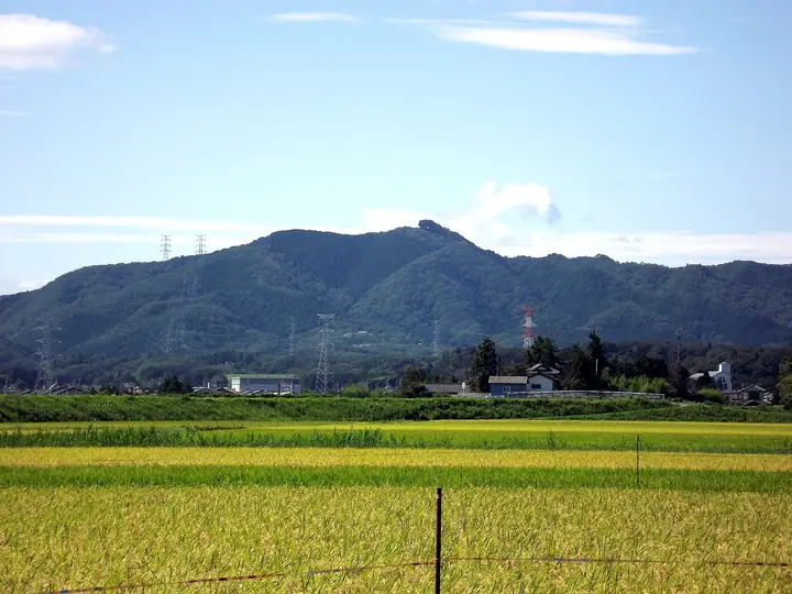
Mt. Karousan, 429.9 m, rises at the northern tip of the Abukuma Highlands on the border of Shinchi Town (Fukushima) and Marumori Town (Miyagi), and is listed among the Fukushima 30, Utsukushima 100 and Tōhoku 100 Mountains. Local tradition holds that the mountain was the home of Tenaga-Myōjin, a long-armed deity who lived with a deer and a wolf — giving the peak its name 'Deer-Wolf Mountain' — and a small shrine still stands at the summit. Four trails on the Shinchi side (Jukai, Tenbō, Keyaki-no-Mori and Zaō-Tenbō, 40–70 minutes) lead to a near-coastal summit with a 360° view stretching across the Pacific Ocean, the Zaō Mountains, the Azuma Range and the town of Shinchi. The annual New Year's Day opening — billed as Japan's earliest 山開き — draws roughly 2,000 visitors for the first sunrise of the year.
Mt. Karousan at a glance
- Weather: The most settled day in the next 7 days is Wed, November 4: clear, gusts up to 10 m/s. Fri, Nov 6, Sat, Nov 7, Sun, Nov 8: strong wind (gusts up to 20 m/s).
- Route: The shortest is Mount Karou Loop via the Jukai and Viewpoint Trails: about 1 h 58 min, 3.2 km, about 300 m of climbing.
Mt. Karousan weather (hourly, 14 days)
Sunrise today 06:03, sunset 16:37
| Tue, 11/3 | Wed, 11/4 | Thu, 11/5 | Fri, 11/6 | Sat, 11/7 | Sun, 11/8 | Mon, 11/9 | Tue, 11/10 | Wed, 11/11 | Thu, 11/12 | Fri, 11/13 | Sat, 11/14 | Sun, 11/15 | Mon, 11/16 | Tue, 11/17 | |||||||||||||||||||||||||||||||||||||||||||||||||||||||||||||||||||||||
|---|---|---|---|---|---|---|---|---|---|---|---|---|---|---|---|---|---|---|---|---|---|---|---|---|---|---|---|---|---|---|---|---|---|---|---|---|---|---|---|---|---|---|---|---|---|---|---|---|---|---|---|---|---|---|---|---|---|---|---|---|---|---|---|---|---|---|---|---|---|---|---|---|---|---|---|---|---|---|---|---|---|---|---|---|---|
| Japan time | 15 | 17 | 19 | 21 | 23 | 1 | 3 | 5 | 7 | 9 | 11 | 13 | 15 | 18 | 21 | 0 | 3 | 6 | 9 | 12 | 15 | 18 | 21 | 0 | 3 | 6 | 9 | 12 | 15 | 18 | 21 | 0 | 3 | 6 | 9 | 12 | 15 | 18 | 21 | 0 | 3 | 6 | 9 | 12 | 15 | 18 | 21 | 0 | 3 | 6 | 9 | 15 | 21 | 3 | 9 | 15 | 21 | 3 | 9 | 15 | 21 | 3 | 9 | 15 | 21 | 3 | 9 | 15 | 21 | 3 | 9 | 15 | 21 | 3 | 9 | 15 | 21 | 3 | 9 | 15 | 21 | 3 | 9 | 15 | |
 |  |   | | | | | | |   | | | | |   |   |   | |   | | | | |   | | | |   | | | | | | |   | | |   | | | | | |   | | | | | | |   | | | | | | | | | |   |  | | | | | | | | | | | | | | | | | | | | | | | ||
| Temperature | °C | 12° | 9° | 7° | 6° | 4° | 4° | 3° | 4° | 7° | 12° | 14° | 14° | 12° | 9° | 9° | 9° | 9° | 10° | 10° | 10° | 11° | 11° | 11° | 10° | 9° | 9° | 15° | 18° | 18° | 13° | 10° | 8° | 7° | 6° | 6° | 7° | 6° | 4° | 4° | 4° | 4° | 5° | 6° | 9° | 8° | 6° | 6° | 6° | 5° | 4° | 6° | 9° | 3° | 0° | 5° | 8° | 4° | 4° | 6° | 10° | 3° | 2° | 8° | 10° | 3° | 5° | 8° | 9° | 1° | 0° | 6° | 8° | 2° | 1° | 9° | 11° | 8° | 8° | 12° | 12° | 5° | 2° | 5° | 8° |
| Precipitation | mm | 0.7 | 3.7 | 10 | 8 | 7 | 1.2 | 0.4 | 0.5 | 0.1 | 0.3 | 0.3 | 0.2 | 0.1 | 0.3 | 0.4 | 0.1 | 6 | 1.6 | 0.2 | 0.2 | 3.0 | 12 | 0.1 | 0.2 | 1.8 | |||||||||||||||||||||||||||||||||||||||||||||||||||||||||||
| New snow | cm | ||||||||||||||||||||||||||||||||||||||||||||||||||||||||||||||||||||||||||||||||||||
| Snow depth | cm | 0 | 0 | 0 | 0 | 0 | 0 | 0 | 0 | 0 | 0 | 0 | 0 | 0 | 0 | 0 | 0 | 0 | 0 | 0 | 0 | 0 | 0 | 0 | 0 | 0 | 0 | 0 | 0 | 0 | 0 | 0 | 0 | 0 | 0 | 0 | 0 | 0 | 0 | 0 | 0 | 0 | 0 | 0 | 0 | 0 | 0 | 0 | 0 | 0 | 0 | 0 | 0 | 0 | 0 | 0 | 0 | 0 | 0 | 0 | 0 | 0 | 0 | 0 | 0 | 0 | 0 | 0 | 0 | 0 | 0 | 0 | 0 | 0 | 0 | 0 | 0 | 0 | 0 | 0 | 0 | 0 | 0 | 0 | 0 |
| Wind | m/s | 5 | 5 | 3 | 2 | 1 | 2 | 2 | 3 | 3 | 3 | 0 | 3 | 4 | 3 | 2 | 2 | 1 | 0 | 1 | 3 | 3 | 2 | 2 | 2 | 1 | 2 | 2 | 6 | 4 | 6 | 8 | 7 | 7 | 6 | 7 | 9 | 8 | 8 | 8 | 8 | 8 | 7 | 7 | 8 | 7 | 5 | 5 | 3 | 3 | 2 | 1 | 1 | 1 | 1 | 2 | 3 | 3 | 3 | 7 | 7 | 2 | 2 | 2 | 3 | 1 | 2 | 3 | 5 | 1 | 2 | 1 | 3 | 2 | 2 | 0 | 1 | 1 | 1 | 2 | 4 | 2 | 2 | 1 | 2 |
| Wind gusts | m/s | 13 | 11 | 10 | 7 | 4 | 4 | 4 | 6 | 7 | 8 | 7 | 7 | 10 | 9 | 7 | 5 | 4 | 3 | 3 | 6 | 7 | 6 | 4 | 4 | 4 | 4 | 6 | 12 | 16 | 13 | 16 | 17 | 15 | 16 | 15 | 20 | 20 | 18 | 18 | 17 | 17 | 17 | 17 | 17 | 18 | 14 | 12 | 10 | 7 | 6 | 4 | 5 | 6 | 4 | 5 | 8 | 7 | 6 | 16 | 16 | 14 | 6 | 5 | 10 | 6 | 6 | 8 | 13 | 11 | 4 | 4 | 7 | 7 | 5 | 5 | 7 | 4 | 4 | 6 | 15 | 10 | 9 | 6 | 6 |
| Wind dir. | ↓ | ↓ | ↓ | ↓ | ↓ | ↓ | ↓ | ↓ | ↓ | ↓ | ↓ | ↓ | ↓ | ↓ | ↓ | ↓ | ↓ | ↓ | ↓ | ↓ | ↓ | ↓ | ↓ | ↓ | ↓ | ↓ | ↓ | ↓ | ↓ | ↓ | ↓ | ↓ | ↓ | ↓ | ↓ | ↓ | ↓ | ↓ | ↓ | ↓ | ↓ | ↓ | ↓ | ↓ | ↓ | ↓ | ↓ | ↓ | ↓ | ↓ | ↓ | ↓ | ↓ | ↓ | ↓ | ↓ | ↓ | ↓ | ↓ | ↓ | ↓ | ↓ | ↓ | ↓ | ↓ | ↓ | ↓ | ↓ | ↓ | ↓ | ↓ | ↓ | ↓ | ↓ | ↓ | ↓ | ↓ | ↓ | ↓ | ↓ | ↓ | ↓ | ↓ | ↓ | |
Mt. Karousan hiking routes
Hiking times are estimates calculated from the terrain.
Lists that include Mt. Karousan
Utsukushima 100 Famous Mountains (Fukushima Prefecture) · 30 Peaks of Fukushima
Mt. Karousan facts
- Elevation
- 430 m
- Location
- Shinchi, Fukushima / Marumori, Miyagi
37.861709, 140.861544 - Season Opens
- January 1
- Website
- www.shinchi-town.jp
- Trail Map
- www.shinchi-town.jp (PDF)
- Wikipedia
- ja.wikipedia.org