
Mt. Kanayama
金山
Ōta-shi, Gunma · Elevation 239 m
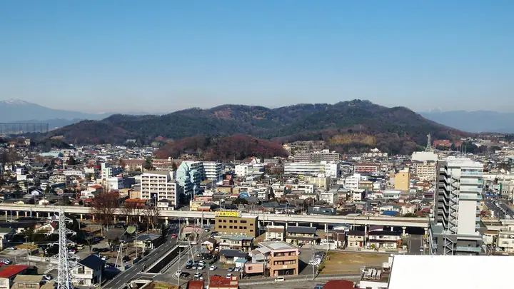
Mt. Kanayama (239 m), also known as Nitta-Kanayama, is a free-standing hill at the centre of Ōta City, Gunma Prefecture. The whole mountain was fortified in the Sengoku period as Kanayama Castle, whose well-preserved dry moats, earthen ramparts, and stone walls earned designations as a National Historic Site and one of Japan's Top 100 Castles. Nitta Shrine stands at the summit overlooking the Ōta plain, and the slopes are noted for cherry blossoms and azaleas in spring and autumn foliage. It appears in lists such as the "100 Mountains of Gunma".
Mt. Kanayama at a glance
- Weather: The most settled day in the next 7 days is Mon, November 9: cloudy, gusts up to 4 m/s.
- Route: The shortest is Kanayama Castle Ruins Return via the Watchtower and Nitta Shrine: about 1 h 34 min, 3.7 km, about 200 m of climbing.
Mt. Kanayama weather (hourly, 14 days)
Sunrise today 06:07, sunset 16:46
| Tue, 11/3 | Wed, 11/4 | Thu, 11/5 | Fri, 11/6 | Sat, 11/7 | Sun, 11/8 | Mon, 11/9 | Tue, 11/10 | Wed, 11/11 | Thu, 11/12 | Fri, 11/13 | Sat, 11/14 | Sun, 11/15 | Mon, 11/16 | Tue, 11/17 | |||||||||||||||||||||||||||||||||||||||||||||||||||||||||||||||||||||||
|---|---|---|---|---|---|---|---|---|---|---|---|---|---|---|---|---|---|---|---|---|---|---|---|---|---|---|---|---|---|---|---|---|---|---|---|---|---|---|---|---|---|---|---|---|---|---|---|---|---|---|---|---|---|---|---|---|---|---|---|---|---|---|---|---|---|---|---|---|---|---|---|---|---|---|---|---|---|---|---|---|---|---|---|---|---|
| Japan time | 21 | 23 | 1 | 3 | 5 | 7 | 9 | 11 | 13 | 15 | 17 | 19 | 21 | 0 | 3 | 6 | 9 | 12 | 15 | 18 | 21 | 0 | 3 | 6 | 9 | 12 | 15 | 18 | 21 | 0 | 3 | 6 | 9 | 12 | 15 | 18 | 21 | 0 | 3 | 6 | 9 | 12 | 15 | 18 | 21 | 0 | 3 | 6 | 9 | 12 | 15 | 21 | 3 | 9 | 15 | 21 | 3 | 9 | 15 | 21 | 3 | 9 | 15 | 21 | 3 | 9 | 15 | 21 | 3 | 9 | 15 | 21 | 3 | 9 | 15 | 21 | 3 | 9 | 15 | 21 | 3 | 9 | 15 | 21 | |
  |   |   | | |   |   | | | | | |   | | | |   |   | | | | |  | |  | | | | | | | | | | | | | | | | | | | | | | |   |   | | | | | | | | | | | |  | | | | | | | | | | | | | | | |   | | | |  | | | | ||
| Temperature | °C | 10° | 10° | 10° | 10° | 10° | 10° | 13° | 15° | 15° | 13° | 12° | 12° | 11° | 11° | 11° | 11° | 13° | 17° | 17° | 15° | 14° | 13° | 12° | 11° | 17° | 22° | 22° | 15° | 12° | 13° | 12° | 10° | 14° | 15° | 13° | 10° | 9° | 8° | 7° | 6° | 11° | 14° | 13° | 10° | 9° | 8° | 8° | 7° | 8° | 10° | 10° | 9° | 8° | 9° | 13° | 8° | 6° | 11° | 11° | 8° | 4° | 9° | 13° | 7° | 5° | 12° | 12° | 7° | 3° | 7° | 11° | 4° | 4° | 9° | 13° | 10° | 9° | 12° | 18° | 11° | 6° | 8° | 11° | 6° |
| Precipitation | mm | 1.0 | 5 | 9 | 10 | 1.6 | 0.8 | 0.2 | 0.2 | 2.5 | 0.5 | 0.3 | 0.1 | 1.2 | 7 | ||||||||||||||||||||||||||||||||||||||||||||||||||||||||||||||||||||||
| New snow | cm | ||||||||||||||||||||||||||||||||||||||||||||||||||||||||||||||||||||||||||||||||||||
| Snow depth | cm | 0 | 0 | 0 | 0 | 0 | 0 | 0 | 0 | 0 | 0 | 0 | 0 | 0 | 0 | 0 | 0 | 0 | 0 | 0 | 0 | 0 | 0 | 0 | 0 | 0 | 0 | 0 | 0 | 0 | 0 | 0 | 0 | 0 | 0 | 0 | 0 | 0 | 0 | 0 | 0 | 0 | 0 | 0 | 0 | 0 | 0 | 0 | 0 | 0 | 0 | 0 | 0 | 0 | 0 | 0 | 0 | 0 | 0 | 0 | 0 | 0 | 0 | 0 | 0 | 0 | 0 | 0 | 0 | 0 | 0 | 0 | 0 | 0 | 0 | 0 | 0 | 0 | 0 | 0 | 0 | 0 | 0 | 0 | 0 |
| Wind | m/s | 0 | 1 | 1 | 1 | 0 | 1 | 0 | 1 | 2 | 3 | 1 | 1 | 2 | 2 | 2 | 2 | 2 | 2 | 0 | 1 | 1 | 1 | 1 | 1 | 1 | 2 | 1 | 1 | 2 | 4 | 5 | 3 | 4 | 5 | 6 | 6 | 6 | 5 | 2 | 2 | 3 | 1 | 2 | 2 | 0 | 0 | 0 | 1 | 1 | 1 | 0 | 1 | 0 | 1 | 2 | 0 | 2 | 5 | 5 | 5 | 1 | 0 | 2 | 1 | 2 | 3 | 6 | 3 | 1 | 1 | 1 | 1 | 1 | 1 | 1 | 1 | 1 | 1 | 7 | 5 | 1 | 1 | 2 | 1 |
| Wind gusts | m/s | 2 | 1 | 2 | 2 | 2 | 2 | 3 | 4 | 6 | 6 | 6 | 3 | 3 | 4 | 4 | 6 | 5 | 5 | 6 | 2 | 2 | 3 | 2 | 2 | 4 | 6 | 6 | 4 | 4 | 7 | 11 | 10 | 8 | 11 | 12 | 15 | 13 | 12 | 10 | 5 | 7 | 7 | 6 | 5 | 3 | 1 | 2 | 2 | 3 | 4 | 4 | 3 | 2 | 3 | 5 | 7 | 4 | 10 | 14 | 12 | 9 | 3 | 5 | 4 | 3 | 7 | 13 | 12 | 7 | 3 | 4 | 4 | 3 | 3 | 4 | 3 | 5 | 4 | 14 | 14 | 12 | 4 | 6 | 5 |
| Wind dir. | ↓ | ↓ | ↓ | ↓ | ↓ | ↓ | ↓ | ↓ | ↓ | ↓ | ↓ | ↓ | ↓ | ↓ | ↓ | ↓ | ↓ | ↓ | ↓ | ↓ | ↓ | ↓ | ↓ | ↓ | ↓ | ↓ | ↓ | ↓ | ↓ | ↓ | ↓ | ↓ | ↓ | ↓ | ↓ | ↓ | ↓ | ↓ | ↓ | ↓ | ↓ | ↓ | ↓ | ↓ | ↓ | ↓ | ↓ | ↓ | ↓ | ↓ | ↓ | ↓ | ↓ | ↓ | ↓ | ↓ | ↓ | ↓ | ↓ | ↓ | ↓ | ↓ | ↓ | ↓ | ↓ | ↓ | ↓ | ↓ | ↓ | ↓ | ↓ | ↓ | ↓ | ↓ | ↓ | ↓ | ↓ | ↓ | ↓ | ↓ | ↓ | ↓ | ↓ | ↓ | |
Mt. Kanayama hiking routes
Hiking times are estimates calculated from the terrain.
Huts, campsites and lodging near Mt. Kanayama
Campsites
- 北金井キャンプ場
Lodging
- パールホテル太田
- Route Inn Grand Ota Ekimae Hotel
- グランドホテル
- モンテローザ大田
- 太田イン
Lists that include Mt. Kanayama
Mt. Kanayama facts
- Also known as
- 新田金山
- Elevation
- 239 m
- Location
- Ōta-shi, Gunma
36.317459, 139.377735 - Website
- www.city.ota.gunma.jp
- Trail Map
- www.city.ota.gunma.jp (PDF)
- Wikipedia
- ja.wikipedia.org