
Mt. Ichigaosan
依遅ヶ尾山
Kyōtango-shi, Kyoto · Elevation 540 m
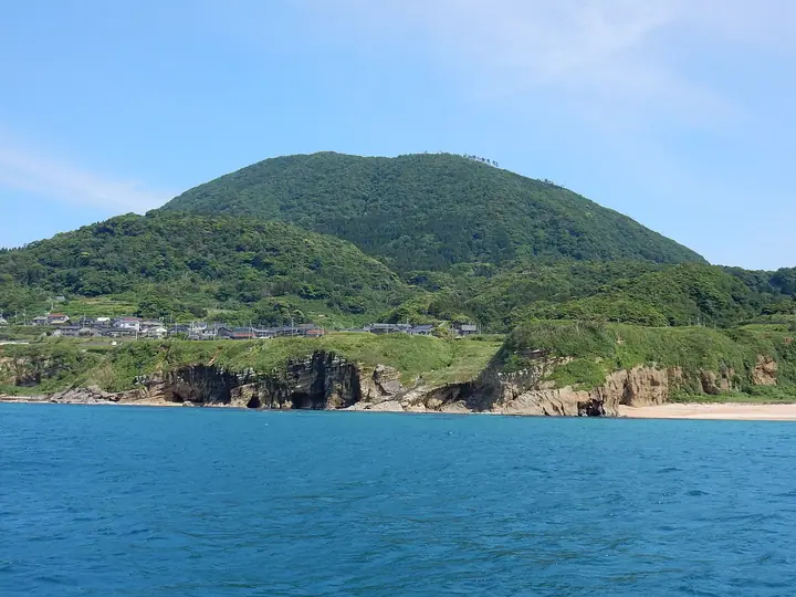
Mt. Ichigao-san (540 m) is a free-standing peak rising in Yabata, Tango-chō, Kyōtango City, Kyoto Prefecture, the only mountain on the Tango Peninsula included in the Kansai Hundred Mountains. Designated as a Class-1 Special Area of Tango-Amanohashidate-Ōeyama Quasi-National Park, the summit affords sweeping views of the Sea of Japan and the Tango coastline. An annual climbing event is held each October together with the Yabata-district festival.
Mt. Ichigaosan at a glance
- Weather: The most settled day in the next 7 days is Thu, November 5: cloudy, gusts up to 5 m/s. Fri, Nov 6, Sat, Nov 7: strong wind (gusts up to 17 m/s).
- Route: The shortest is Kyotango Return to Ichigao, the Aircraft-Carrier Peak at the Northern Tip of the Tango Peninsula: about 2 h 2 min, 3.4 km, about 360 m of climbing.
Mt. Ichigaosan weather (hourly, 14 days)
Sunrise today 06:23, sunset 17:03
| Tue, 11/3 | Wed, 11/4 | Thu, 11/5 | Fri, 11/6 | Sat, 11/7 | Sun, 11/8 | Mon, 11/9 | Tue, 11/10 | Wed, 11/11 | Thu, 11/12 | Fri, 11/13 | Sat, 11/14 | Sun, 11/15 | Mon, 11/16 | Tue, 11/17 | |||||||||||||||||||||||||||||||||||||||||||||||||||||||||||||||||||||||
|---|---|---|---|---|---|---|---|---|---|---|---|---|---|---|---|---|---|---|---|---|---|---|---|---|---|---|---|---|---|---|---|---|---|---|---|---|---|---|---|---|---|---|---|---|---|---|---|---|---|---|---|---|---|---|---|---|---|---|---|---|---|---|---|---|---|---|---|---|---|---|---|---|---|---|---|---|---|---|---|---|---|---|---|---|---|
| Japan time | 21 | 23 | 1 | 3 | 5 | 7 | 9 | 11 | 13 | 15 | 17 | 19 | 21 | 0 | 3 | 6 | 9 | 12 | 15 | 18 | 21 | 0 | 3 | 6 | 9 | 12 | 15 | 18 | 21 | 0 | 3 | 6 | 9 | 12 | 15 | 18 | 21 | 0 | 3 | 6 | 9 | 12 | 15 | 18 | 21 | 0 | 3 | 6 | 9 | 12 | 15 | 21 | 3 | 9 | 15 | 21 | 3 | 9 | 15 | 21 | 3 | 9 | 15 | 21 | 3 | 9 | 15 | 21 | 3 | 9 | 15 | 21 | 3 | 9 | 15 | 21 | 3 | 9 | 15 | 21 | 3 | 9 | 15 | 21 | |
  | | |  |   |   | |   | | | |   | |   |   | | |   | | |   | | | |   | |   | | | | | | | |   | | | | | | | | | | | | | | | | | | | | | | | | | | | | | | | | | | | |  | | | | | | | | | | | | | | ||
| Temperature | °C | 12° | 12° | 12° | 12° | 12° | 13° | 14° | 15° | 14° | 14° | 13° | 13° | 12° | 12° | 12° | 13° | 14° | 17° | 16° | 15° | 14° | 14° | 14° | 13° | 16° | 15° | 14° | 14° | 12° | 11° | 10° | 10° | 10° | 10° | 9° | 10° | 9° | 9° | 9° | 9° | 10° | 10° | 10° | 10° | 11° | 11° | 11° | 10° | 12° | 12° | 11° | 10° | 11° | 11° | 13° | 9° | 8° | 10° | 10° | 9° | 9° | 10° | 11° | 11° | 10° | 11° | 10° | 10° | 10° | 11° | 12° | 10° | 10° | 12° | 14° | 13° | 14° | 13° | 12° | 8° | 9° | 9° | 10° | 10° |
| Precipitation | mm | 0.6 | 0.4 | 1.2 | 6 | 11 | 1.9 | 2.0 | 1.2 | 0.3 | 0.2 | 0.3 | 0.8 | 1.2 | 0.4 | 0.5 | 0.2 | 0.6 | 2.2 | 2.6 | 9 | 0.2 | 3.6 | 3.5 | 3.3 | 0.7 | 0.2 | 0.2 | 0.7 | 3.1 | 3.0 | 1.2 | 0.2 | 6 | 4.1 | 4.1 | 6 | 0.4 | 0.2 | 0.2 | |||||||||||||||||||||||||||||||||||||||||||||
| New snow | cm | ||||||||||||||||||||||||||||||||||||||||||||||||||||||||||||||||||||||||||||||||||||
| Snow depth | cm | 0 | 0 | 0 | 0 | 0 | 0 | 0 | 0 | 0 | 0 | 0 | 0 | 0 | 0 | 0 | 0 | 0 | 0 | 0 | 0 | 0 | 0 | 0 | 0 | 0 | 0 | 0 | 0 | 0 | 0 | 0 | 0 | 0 | 0 | 0 | 0 | 0 | 0 | 0 | 0 | 0 | 0 | 0 | 0 | 0 | 0 | 0 | 0 | 0 | 0 | 0 | 0 | 0 | 0 | 0 | 0 | 0 | 0 | 0 | 0 | 0 | 0 | 0 | 0 | 0 | 0 | 0 | 0 | 0 | 0 | 0 | 0 | 0 | 0 | 0 | 0 | 0 | 0 | 0 | 0 | 0 | 0 | 0 | 0 |
| Wind | m/s | 4 | 3 | 3 | 4 | 4 | 4 | 4 | 4 | 5 | 4 | 2 | 1 | 2 | 1 | 1 | 2 | 2 | 1 | 2 | 3 | 1 | 5 | 7 | 7 | 9 | 10 | 10 | 10 | 10 | 9 | 9 | 9 | 8 | 9 | 8 | 7 | 6 | 6 | 6 | 5 | 5 | 5 | 5 | 4 | 4 | 3 | 2 | 1 | 4 | 5 | 4 | 6 | 8 | 5 | 9 | 9 | 11 | 9 | 6 | 4 | 2 | 2 | 4 | 6 | 6 | 7 | 6 | 5 | 4 | 3 | 3 | 3 | 4 | 4 | 6 | 5 | 3 | 5 | 11 | 7 | 5 | 5 | 4 | 3 |
| Wind gusts | m/s | 6 | 6 | 6 | 7 | 7 | 7 | 8 | 8 | 9 | 9 | 7 | 4 | 3 | 4 | 4 | 3 | 5 | 4 | 4 | 5 | 6 | 9 | 11 | 11 | 13 | 16 | 17 | 17 | 15 | 15 | 15 | 15 | 15 | 15 | 14 | 14 | 12 | 10 | 10 | 10 | 9 | 9 | 9 | 9 | 8 | 7 | 5 | 4 | 7 | 9 | 10 | 10 | 14 | 12 | 15 | 17 | 21 | 18 | 15 | 11 | 8 | 5 | 7 | 12 | 10 | 13 | 12 | 10 | 8 | 7 | 6 | 6 | 7 | 7 | 12 | 11 | 11 | 13 | 18 | 18 | 12 | 9 | 8 | 7 |
| Wind dir. | ↓ | ↓ | ↓ | ↓ | ↓ | ↓ | ↓ | ↓ | ↓ | ↓ | ↓ | ↓ | ↓ | ↓ | ↓ | ↓ | ↓ | ↓ | ↓ | ↓ | ↓ | ↓ | ↓ | ↓ | ↓ | ↓ | ↓ | ↓ | ↓ | ↓ | ↓ | ↓ | ↓ | ↓ | ↓ | ↓ | ↓ | ↓ | ↓ | ↓ | ↓ | ↓ | ↓ | ↓ | ↓ | ↓ | ↓ | ↓ | ↓ | ↓ | ↓ | ↓ | ↓ | ↓ | ↓ | ↓ | ↓ | ↓ | ↓ | ↓ | ↓ | ↓ | ↓ | ↓ | ↓ | ↓ | ↓ | ↓ | ↓ | ↓ | ↓ | ↓ | ↓ | ↓ | ↓ | ↓ | ↓ | ↓ | ↓ | ↓ | ↓ | ↓ | ↓ | ↓ | |
Mt. Ichigaosan hiking routes
Hiking times are estimates calculated from the terrain.
Huts, campsites and lodging near Mt. Ichigaosan
Campsites
- てんきてんき村オートキャンプ場 受付
- てんきてんき村オートキャンプ場
Lodging
- 海雲館
Lists that include Mt. Ichigaosan
Mt. Ichigaosan facts
- Elevation
- 540 m
- Location
- Kyōtango-shi, Kyoto
35.734099, 135.137479 - National Park
- 丹後天橋立大江山国定公園
- Website
- www.kyotango.gr.jp
- Wikipedia
- ja.wikipedia.org