
Mt. Hongū
本宮山
Ōita-shi, Oita · Elevation 608 m
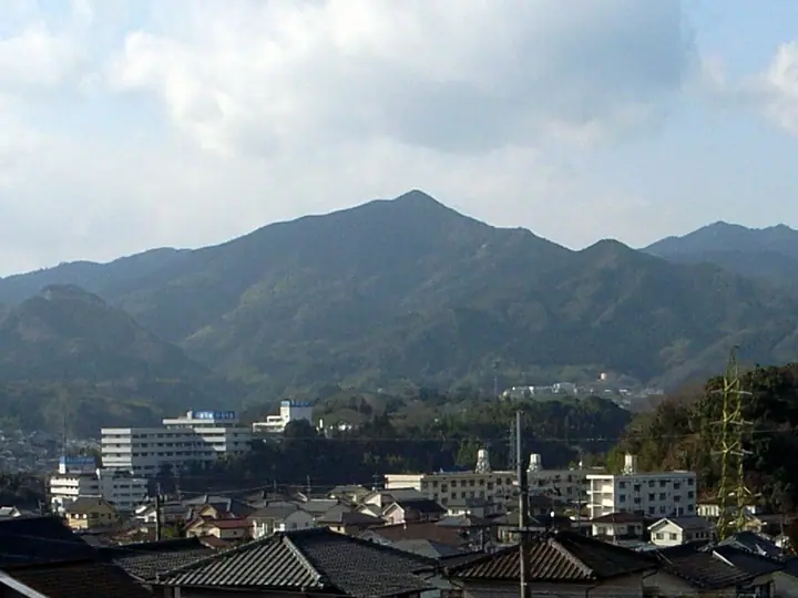
Hongū-san is a 607.6 m peak in the Kamihanda district of southern Ōita City, Ōita Prefecture, part of a small range that includes Ryōzen and Shōji-dake. At the summit stand the Hongū shrine — the original sanctuary of Nishi-Samuta Shrine, the ichinomiya of Bungo Province — and a 10 m megalith called Sekihōden, said to mark a visit by Empress Jingū. After the Ōtomo clan relocated the main shrine down to the foot in 1409, the summit shrine became the inner sanctuary ("hongū"), giving the mountain its present name. Ōita City designates the "Hongū-san Therapy Road," one of its certified Forest Therapy bases; the trail can be reached from Nishi-Samuta Shrine or via the Hongū-san forest road. The mountain appears in the New Ōita 100 and "Low Mountains of Ōita" lists.
Mt. Hongū at a glance
- Weather: The most settled day in the next 7 days is Sun, November 8: clear, gusts up to 7 m/s.
Mt. Hongū weather (hourly, 14 days)
Sunrise today 06:33, sunset 17:22
| Tue, 11/3 | Wed, 11/4 | Thu, 11/5 | Fri, 11/6 | Sat, 11/7 | Sun, 11/8 | Mon, 11/9 | Tue, 11/10 | Wed, 11/11 | Thu, 11/12 | Fri, 11/13 | Sat, 11/14 | Sun, 11/15 | Mon, 11/16 | Tue, 11/17 | |||||||||||||||||||||||||||||||||||||||||||||||||||||||||||||||||||||||
|---|---|---|---|---|---|---|---|---|---|---|---|---|---|---|---|---|---|---|---|---|---|---|---|---|---|---|---|---|---|---|---|---|---|---|---|---|---|---|---|---|---|---|---|---|---|---|---|---|---|---|---|---|---|---|---|---|---|---|---|---|---|---|---|---|---|---|---|---|---|---|---|---|---|---|---|---|---|---|---|---|---|---|---|---|---|
| Japan time | 15 | 17 | 19 | 21 | 23 | 1 | 3 | 5 | 7 | 9 | 11 | 13 | 15 | 18 | 21 | 0 | 3 | 6 | 9 | 12 | 15 | 18 | 21 | 0 | 3 | 6 | 9 | 12 | 15 | 18 | 21 | 0 | 3 | 6 | 9 | 12 | 15 | 18 | 21 | 0 | 3 | 6 | 9 | 12 | 15 | 18 | 21 | 0 | 3 | 6 | 9 | 15 | 21 | 3 | 9 | 15 | 21 | 3 | 9 | 15 | 21 | 3 | 9 | 15 | 21 | 3 | 9 | 15 | 21 | 3 | 9 | 15 | 21 | 3 | 9 | 15 | 21 | 3 | 9 | 15 | 21 | 3 | 9 | 15 | |
  |   |   |   | | | | |   | | |   | |   | |   |   | |  |   | | | | | |  | | | | | | | | | | | | | | | | | | | | | | | | | | |   | | | | | | | | |  | | | | | | | | | | | | | | |   | | | | | | | | ||
| Temperature | °C | 15° | 14° | 11° | 11° | 10° | 9° | 10° | 10° | 10° | 13° | 15° | 16° | 16° | 13° | 12° | 11° | 12° | 12° | 14° | 18° | 18° | 16° | 15° | 14° | 14° | 12° | 15° | 17° | 16° | 10° | 8° | 7° | 6° | 5° | 9° | 12° | 12° | 7° | 4° | 2° | 1° | 1° | 10° | 12° | 12° | 10° | 9° | 7° | 8° | 8° | 12° | 14° | 8° | 5° | 11° | 14° | 7° | 7° | 8° | 11° | 3° | 1° | 8° | 13° | 3° | 3° | 11° | 13° | 8° | 8° | 11° | 16° | 9° | 8° | 14° | 15° | 11° | 12° | 14° | 16° | 9° | 10° | 10° | 13° |
| Precipitation | mm | 0.1 | 0.1 | 0.4 | 0.5 | 0.3 | 1.1 | 0.2 | 4.2 | 2.4 | 0.1 | 0.3 | |||||||||||||||||||||||||||||||||||||||||||||||||||||||||||||||||||||||||
| New snow | cm | ||||||||||||||||||||||||||||||||||||||||||||||||||||||||||||||||||||||||||||||||||||
| Snow depth | cm | 0 | 0 | 0 | 0 | 0 | 0 | 0 | 0 | 0 | 0 | 0 | 0 | 0 | 0 | 0 | 0 | 0 | 0 | 0 | 0 | 0 | 0 | 0 | 0 | 0 | 0 | 0 | 0 | 0 | 0 | 0 | 0 | 0 | 0 | 0 | 0 | 0 | 0 | 0 | 0 | 0 | 0 | 0 | 0 | 0 | 0 | 0 | 0 | 0 | 0 | 0 | 0 | 0 | 0 | 0 | 0 | 0 | 0 | 0 | 0 | 0 | 0 | 0 | 0 | 0 | 0 | 0 | 0 | 0 | 0 | 0 | 0 | 0 | 0 | 0 | 0 | 0 | 0 | 0 | 0 | 0 | 0 | 0 | 0 |
| Wind | m/s | 3 | 2 | 2 | 2 | 2 | 2 | 2 | 1 | 2 | 1 | 2 | 0 | 2 | 1 | 1 | 1 | 1 | 1 | 1 | 1 | 1 | 1 | 1 | 1 | 2 | 2 | 3 | 4 | 4 | 3 | 3 | 3 | 3 | 2 | 4 | 4 | 4 | 2 | 1 | 1 | 1 | 1 | 1 | 2 | 2 | 1 | 1 | 1 | 1 | 1 | 3 | 4 | 2 | 1 | 3 | 4 | 2 | 3 | 5 | 4 | 1 | 1 | 1 | 2 | 1 | 2 | 1 | 3 | 1 | 1 | 1 | 1 | 2 | 2 | 3 | 2 | 0 | 1 | 3 | 5 | 1 | 3 | 3 | 4 |
| Wind gusts | m/s | 9 | 8 | 6 | 6 | 5 | 4 | 4 | 4 | 4 | 4 | 6 | 6 | 5 | 6 | 2 | 4 | 3 | 2 | 4 | 5 | 6 | 4 | 3 | 4 | 6 | 7 | 8 | 11 | 11 | 9 | 8 | 8 | 8 | 8 | 10 | 11 | 11 | 10 | 5 | 4 | 3 | 3 | 3 | 7 | 7 | 6 | 2 | 3 | 3 | 3 | 7 | 10 | 9 | 4 | 7 | 11 | 10 | 9 | 11 | 11 | 10 | 4 | 4 | 6 | 6 | 5 | 5 | 10 | 7 | 4 | 4 | 6 | 5 | 6 | 7 | 9 | 6 | 4 | 8 | 12 | 11 | 8 | 8 | 10 |
| Wind dir. | ↓ | ↓ | ↓ | ↓ | ↓ | ↓ | ↓ | ↓ | ↓ | ↓ | ↓ | ↓ | ↓ | ↓ | ↓ | ↓ | ↓ | ↓ | ↓ | ↓ | ↓ | ↓ | ↓ | ↓ | ↓ | ↓ | ↓ | ↓ | ↓ | ↓ | ↓ | ↓ | ↓ | ↓ | ↓ | ↓ | ↓ | ↓ | ↓ | ↓ | ↓ | ↓ | ↓ | ↓ | ↓ | ↓ | ↓ | ↓ | ↓ | ↓ | ↓ | ↓ | ↓ | ↓ | ↓ | ↓ | ↓ | ↓ | ↓ | ↓ | ↓ | ↓ | ↓ | ↓ | ↓ | ↓ | ↓ | ↓ | ↓ | ↓ | ↓ | ↓ | ↓ | ↓ | ↓ | ↓ | ↓ | ↓ | ↓ | ↓ | ↓ | ↓ | ↓ | ↓ | |
Mt. Hongū facts
- Also known as
- 寒田山 · 西寒田山
- Elevation
- 608 m
- Location
- Ōita-shi, Oita
33.145385, 131.589968 - Website
- www.oita-foresttherapy.jp
- Trail Map
- www.oita-foresttherapy.jp (PDF)
- Wikipedia
- ja.wikipedia.org