
Mt. Fujin
風神山
Hitachiōta-shi, Ibaraki · Elevation 242 m
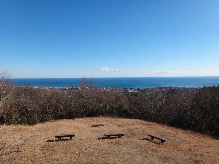
Mt. Fūjin (also Kazenokami-yama) is a 241.9 m peak on the boundary between Hitachi and Hitachi-Ōta cities in Ibaraki Prefecture, marking the southern tip of the Taga mountain range where the highlands meet the north-east edge of the Kantō Plain. The summit area lies within Takasuzu Prefectural Natural Park and is maintained by Hitachi City as Fūjin-yama Nature Park, offering sweeping views of the Pacific Ocean and the city of Hitachi. The mountain's name — 'Wind God' — comes from the constant winds where cold northerlies and warm southerlies meet, and a stele to Fūjin and Raijin stands near the top. The connecting ridge to Mt. Kanmine and Mt. Takasuzu is known locally as the 'Hitachi Alps', and the peak features in the 'Mountains of Ibaraki' prefectural climbing guide, drawing day hikers from the Tokyo area.
Mt. Fujin at a glance
- Weather: The most settled day in the next 7 days is Fri, November 6: clear, gusts up to 7 m/s.
Mt. Fujin weather (hourly, 14 days)
Sunrise today 06:02, sunset 16:40
| Tue, 11/3 | Wed, 11/4 | Thu, 11/5 | Fri, 11/6 | Sat, 11/7 | Sun, 11/8 | Mon, 11/9 | Tue, 11/10 | Wed, 11/11 | Thu, 11/12 | Fri, 11/13 | Sat, 11/14 | Sun, 11/15 | Mon, 11/16 | Tue, 11/17 | |||||||||||||||||||||||||||||||||||||||||||||||||||||||||||||||||||||||
|---|---|---|---|---|---|---|---|---|---|---|---|---|---|---|---|---|---|---|---|---|---|---|---|---|---|---|---|---|---|---|---|---|---|---|---|---|---|---|---|---|---|---|---|---|---|---|---|---|---|---|---|---|---|---|---|---|---|---|---|---|---|---|---|---|---|---|---|---|---|---|---|---|---|---|---|---|---|---|---|---|---|---|---|---|---|
| Japan time | 15 | 17 | 19 | 21 | 23 | 1 | 3 | 5 | 7 | 9 | 11 | 13 | 15 | 18 | 21 | 0 | 3 | 6 | 9 | 12 | 15 | 18 | 21 | 0 | 3 | 6 | 9 | 12 | 15 | 18 | 21 | 0 | 3 | 6 | 9 | 12 | 15 | 18 | 21 | 0 | 3 | 6 | 9 | 12 | 15 | 18 | 21 | 0 | 3 | 6 | 9 | 15 | 21 | 3 | 9 | 15 | 21 | 3 | 9 | 15 | 21 | 3 | 9 | 15 | 21 | 3 | 9 | 15 | 21 | 3 | 9 | 15 | 21 | 3 | 9 | 15 | 21 | 3 | 9 | 15 | 21 | 3 | 9 | 15 | |
  |   |  | |   | |   | |   | | | | | | |   | | |   |   | |   |   | | | |  | | | | | | |  | | | | | | | | | | | | | | | | | | | | | |   | |   | | | |  | | | | | | | | | | | | | |   | | | | | | | | | ||
| Temperature | °C | 17° | 13° | 11° | 10° | 10° | 11° | 11° | 11° | 10° | 13° | 15° | 14° | 14° | 13° | 14° | 13° | 13° | 14° | 14° | 16° | 17° | 14° | 12° | 12° | 11° | 11° | 17° | 21° | 21° | 15° | 15° | 14° | 12° | 10° | 13° | 14° | 13° | 9° | 9° | 8° | 8° | 8° | 11° | 14° | 13° | 9° | 9° | 8° | 9° | 8° | 9° | 11° | 9° | 8° | 10° | 9° | 6° | 5° | 10° | 13° | 8° | 6° | 10° | 13° | 6° | 6° | 13° | 12° | 6° | 3° | 9° | 11° | 5° | 4° | 12° | 15° | 13° | 13° | 15° | 18° | 10° | 6° | 9° | 10° |
| Precipitation | mm | 7 | 2.4 | 12 | 18 | 8 | 3.7 | 0.4 | 0.2 | 0.1 | 0.3 | 0.1 | 0.2 | 3.3 | 0.2 | 0.3 | 3.8 | 14 | |||||||||||||||||||||||||||||||||||||||||||||||||||||||||||||||||||
| New snow | cm | ||||||||||||||||||||||||||||||||||||||||||||||||||||||||||||||||||||||||||||||||||||
| Snow depth | cm | 0 | 0 | 0 | 0 | 0 | 0 | 0 | 0 | 0 | 0 | 0 | 0 | 0 | 0 | 0 | 0 | 0 | 0 | 0 | 0 | 0 | 0 | 0 | 0 | 0 | 0 | 0 | 0 | 0 | 0 | 0 | 0 | 0 | 0 | 0 | 0 | 0 | 0 | 0 | 0 | 0 | 0 | 0 | 0 | 0 | 0 | 0 | 0 | 0 | 0 | 0 | 0 | 0 | 0 | 0 | 0 | 0 | 0 | 0 | 0 | 0 | 0 | 0 | 0 | 0 | 0 | 0 | 0 | 0 | 0 | 0 | 0 | 0 | 0 | 0 | 0 | 0 | 0 | 0 | 0 | 0 | 0 | 0 | 0 |
| Wind | m/s | 3 | 2 | 2 | 2 | 2 | 2 | 2 | 2 | 2 | 2 | 2 | 3 | 3 | 2 | 2 | 2 | 3 | 4 | 7 | 5 | 0 | 1 | 2 | 2 | 1 | 2 | 1 | 2 | 2 | 1 | 5 | 6 | 5 | 4 | 6 | 6 | 7 | 7 | 5 | 6 | 7 | 7 | 6 | 5 | 3 | 2 | 2 | 2 | 2 | 3 | 3 | 3 | 3 | 3 | 5 | 4 | 2 | 3 | 4 | 6 | 4 | 2 | 1 | 2 | 1 | 2 | 4 | 5 | 4 | 1 | 1 | 2 | 1 | 2 | 1 | 4 | 1 | 1 | 1 | 5 | 5 | 3 | 2 | 3 |
| Wind gusts | m/s | 9 | 6 | 5 | 4 | 4 | 3 | 5 | 5 | 5 | 5 | 6 | 8 | 7 | 7 | 5 | 5 | 7 | 9 | 15 | 14 | 11 | 2 | 5 | 4 | 4 | 4 | 5 | 7 | 6 | 5 | 10 | 12 | 13 | 9 | 12 | 15 | 14 | 15 | 15 | 13 | 16 | 15 | 14 | 13 | 11 | 7 | 4 | 3 | 5 | 6 | 7 | 8 | 8 | 9 | 10 | 12 | 8 | 6 | 11 | 15 | 13 | 8 | 6 | 6 | 5 | 4 | 9 | 12 | 10 | 9 | 5 | 5 | 5 | 5 | 5 | 9 | 8 | 6 | 5 | 12 | 17 | 10 | 7 | 9 |
| Wind dir. | ↓ | ↓ | ↓ | ↓ | ↓ | ↓ | ↓ | ↓ | ↓ | ↓ | ↓ | ↓ | ↓ | ↓ | ↓ | ↓ | ↓ | ↓ | ↓ | ↓ | ↓ | ↓ | ↓ | ↓ | ↓ | ↓ | ↓ | ↓ | ↓ | ↓ | ↓ | ↓ | ↓ | ↓ | ↓ | ↓ | ↓ | ↓ | ↓ | ↓ | ↓ | ↓ | ↓ | ↓ | ↓ | ↓ | ↓ | ↓ | ↓ | ↓ | ↓ | ↓ | ↓ | ↓ | ↓ | ↓ | ↓ | ↓ | ↓ | ↓ | ↓ | ↓ | ↓ | ↓ | ↓ | ↓ | ↓ | ↓ | ↓ | ↓ | ↓ | ↓ | ↓ | ↓ | ↓ | ↓ | ↓ | ↓ | ↓ | ↓ | ↓ | ↓ | ↓ | ↓ | |
Huts, campsites and lodging near Mt. Fujin
Lodging
- home
- hotel rapallo
- Home
- Kuji Sunpia Hitachi
- Hotel Sankotei
Lists that include Mt. Fujin
Mt. Fujin facts
- Also known as
- かぜのかみやま
- Elevation
- 242 m
- Location
- Hitachiōta-shi, Ibaraki
36.526984, 140.599567 - Website
- www.kankou-hitachi.jp
- Trail Map
- www.kankou-hitachi.jp (PDF)
- Wikipedia
- ja.wikipedia.org