
Mt. Esan
恵山
Hakodate, Hokkaido · Elevation 617 m
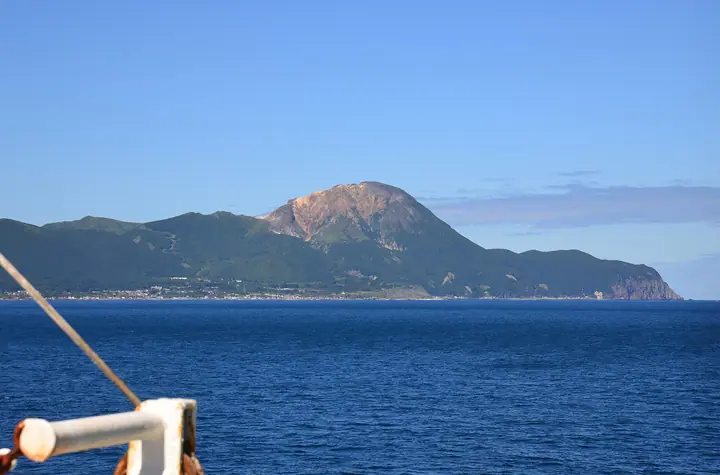
Mount Esan is a 617 m active volcano at the south-eastern tip of the Oshima Peninsula in Hakodate City, Hokkaido, projecting into the Pacific. Its name comes from the Ainu 'e-san' ('a mountain from which lava emerges'); after a small eruption in 1874 it has remained mildly active, with fumaroles still venting on its western flank. The mountain forms the heart of Esan Prefectural Natural Park designated in 1961, famed for some 600,000 Yezo azaleas and more than 60 species of alpine plants. From the crater-floor parking it is roughly 70 minutes to the summit via the Gongendō course.
Mt. Esan at a glance
- Weather: The most settled day in the next 7 days is Thu, November 5: cloudy, gusts up to 4 m/s. Sat, Nov 7, Sun, Nov 8: strong wind (gusts up to 18 m/s).
- Route: The shortest is Mount Esan Return from the Crater Plateau Parking Area via the Gongendo Route: about 2 h 55 min, 5.1 km, about 320 m of climbing.
Mt. Esan weather (hourly, 14 days)
Sunrise today 06:09, sunset 16:29
| Tue, 11/3 | Wed, 11/4 | Thu, 11/5 | Fri, 11/6 | Sat, 11/7 | Sun, 11/8 | Mon, 11/9 | Tue, 11/10 | Wed, 11/11 | Thu, 11/12 | Fri, 11/13 | Sat, 11/14 | Sun, 11/15 | Mon, 11/16 | Tue, 11/17 | |||||||||||||||||||||||||||||||||||||||||||||||||||||||||||||||||||||||
|---|---|---|---|---|---|---|---|---|---|---|---|---|---|---|---|---|---|---|---|---|---|---|---|---|---|---|---|---|---|---|---|---|---|---|---|---|---|---|---|---|---|---|---|---|---|---|---|---|---|---|---|---|---|---|---|---|---|---|---|---|---|---|---|---|---|---|---|---|---|---|---|---|---|---|---|---|---|---|---|---|---|---|---|---|---|
| Japan time | 15 | 17 | 19 | 21 | 23 | 1 | 3 | 5 | 7 | 9 | 11 | 13 | 15 | 18 | 21 | 0 | 3 | 6 | 9 | 12 | 15 | 18 | 21 | 0 | 3 | 6 | 9 | 12 | 15 | 18 | 21 | 0 | 3 | 6 | 9 | 12 | 15 | 18 | 21 | 0 | 3 | 6 | 9 | 12 | 15 | 18 | 21 | 0 | 3 | 6 | 9 | 15 | 21 | 3 | 9 | 15 | 21 | 3 | 9 | 15 | 21 | 3 | 9 | 15 | 21 | 3 | 9 | 15 | 21 | 3 | 9 | 15 | 21 | 3 | 9 | 15 | 21 | 3 | 9 | 15 | 21 | 3 | 9 | 15 | |
 |  | | | |   | | | | | | | |  | |   | | |   | |   |   | | | | |   | | | | | |   |   |   | |   | | | | | |   | | | | | |   | | | |   | | | | |   |   |   |   | |   | | | |   | |  | | | | | | | | |   | | | | | | | ||
| Temperature | °C | 6° | 3° | 2° | 2° | 4° | 5° | 3° | 4° | 3° | 5° | 6° | 7° | 6° | 4° | 3° | 3° | 4° | 5° | 9° | 10° | 10° | 8° | 9° | 10° | 9° | 9° | 11° | 13° | 10° | 6° | 3° | 1° | 0° | -1° | 0° | 1° | 0° | -1° | 0° | -1° | -1° | -1° | 1° | 2° | 1° | 0° | -1° | 0° | -1° | -1° | 1° | 1° | -2° | -2° | 1° | 1° | 1° | 0° | 0° | 4° | 2° | 0° | 3° | 4° | 0° | -1° | 0° | 1° | 0° | -1° | 2° | 3° | 1° | 3° | 7° | 9° | 7° | 5° | 5° | 3° | 0° | -1° | 2° | 4° |
| Precipitation | mm | 0.2 | 0.9 | 0.4 | 0.2 | 4.3 | 3.4 | 1.2 | 0.2 | 0.2 | 0.5 | 0.1 | 0.2 | 0.1 | 0.1 | 0.1 | 0.2 | 2.5 | 3.2 | 0.7 | 0.1 | 0.2 | 0.2 | 3.3 | 0.3 | 1.3 | |||||||||||||||||||||||||||||||||||||||||||||||||||||||||||
| New snow | cm | <.1 | <.1 | 0.1 | <.1 | <.1 | <.1 | <.1 | <.1 | <.1 | 0.1 | <.1 | |||||||||||||||||||||||||||||||||||||||||||||||||||||||||||||||||||||||||
| Snow depth | cm | 0 | 0 | 0 | 0 | 0 | 0 | 0 | 0 | 0 | 0 | 0 | 0 | 0 | 0 | 0 | 0 | 0 | 0 | 0 | 0 | 0 | 0 | 0 | 0 | 0 | 0 | 0 | 0 | 0 | 0 | 0 | 0 | 0 | 0 | 0 | 0 | 0 | 0 | 0 | 0 | 0 | 0 | 0 | 0 | 0 | 0 | 0 | 0 | 0 | 0 | 0 | 0 | 0 | 0 | 0 | 0 | 0 | 0 | 0 | 0 | 0 | 0 | 0 | 0 | 0 | 0 | 0 | 0 | 0 | 0 | 0 | 0 | 0 | 0 | 0 | 0 | 0 | 0 | 0 | 0 | 0 | 0 | 0 | 0 |
| Wind | m/s | 6 | 5 | 3 | 2 | 4 | 6 | 3 | 4 | 5 | 5 | 3 | 2 | 1 | 2 | 2 | 2 | 2 | 1 | 0 | 1 | 1 | 1 | 4 | 4 | 2 | 2 | 5 | 4 | 5 | 8 | 9 | 9 | 7 | 7 | 7 | 10 | 8 | 8 | 8 | 8 | 7 | 7 | 8 | 9 | 9 | 7 | 4 | 4 | 4 | 4 | 5 | 5 | 3 | 3 | 2 | 4 | 6 | 8 | 7 | 5 | 5 | 2 | 2 | 4 | 4 | 4 | 8 | 8 | 6 | 3 | 3 | 2 | 2 | 3 | 6 | 5 | 3 | 2 | 9 | 9 | 9 | 4 | 3 | 4 |
| Wind gusts | m/s | 11 | 10 | 8 | 6 | 8 | 11 | 12 | 8 | 8 | 10 | 9 | 6 | 5 | 4 | 5 | 6 | 5 | 4 | 4 | 3 | 4 | 2 | 6 | 8 | 7 | 4 | 9 | 10 | 12 | 14 | 16 | 17 | 16 | 14 | 14 | 18 | 18 | 15 | 16 | 15 | 14 | 13 | 15 | 16 | 17 | 15 | 13 | 8 | 8 | 7 | 9 | 11 | 10 | 6 | 6 | 9 | 11 | 17 | 15 | 13 | 10 | 8 | 5 | 11 | 9 | 9 | 14 | 15 | 14 | 10 | 6 | 6 | 5 | 6 | 10 | 12 | 9 | 6 | 15 | 17 | 18 | 16 | 8 | 8 |
| Wind dir. | ↓ | ↓ | ↓ | ↓ | ↓ | ↓ | ↓ | ↓ | ↓ | ↓ | ↓ | ↓ | ↓ | ↓ | ↓ | ↓ | ↓ | ↓ | ↓ | ↓ | ↓ | ↓ | ↓ | ↓ | ↓ | ↓ | ↓ | ↓ | ↓ | ↓ | ↓ | ↓ | ↓ | ↓ | ↓ | ↓ | ↓ | ↓ | ↓ | ↓ | ↓ | ↓ | ↓ | ↓ | ↓ | ↓ | ↓ | ↓ | ↓ | ↓ | ↓ | ↓ | ↓ | ↓ | ↓ | ↓ | ↓ | ↓ | ↓ | ↓ | ↓ | ↓ | ↓ | ↓ | ↓ | ↓ | ↓ | ↓ | ↓ | ↓ | ↓ | ↓ | ↓ | ↓ | ↓ | ↓ | ↓ | ↓ | ↓ | ↓ | ↓ | ↓ | ↓ | ↓ | |
Mt. Esan live cameras
Mt. Esan hiking routes
Hiking times are estimates calculated from the terrain.
Huts, campsites and lodging near Mt. Esan
Lodging
- 恵山温泉旅館
- ホテル恵風
- 石田温泉
Lists that include Mt. Esan
New Japan 100 Famous Mountains · 100 Low Mountains of Japan · Illustrated Collection of Japan's Famous Mountains · Hokkaido 100 Famous Mountains · Elevations of 1003 Mountains of Japan · 1000 Mountains of Japan
Mt. Esan facts
- Also known as
- Mount E
- Elevation
- 617 m
- Location
- Hakodate, Hokkaido
41.804678, 141.166157 - Volcano
- Active volcano (恵山)
- Website
- www.city.hakodate.hokkaido.jp
- Trail Map
- www.city.hakodate.hokkaido.jp
- Wikipedia
- ja.wikipedia.org