
Mount Yamizo
八溝山
Tanagura, Fukushima · Elevation 1,022 m
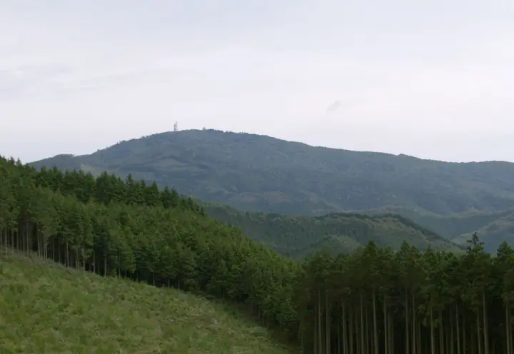
Mount Yamizo is a 1,022.2 m peak straddling Daigo Town in Kuji District (Ibaraki) and Tanagura and Yamatsuri towns in Higashi-Shirakawa District (Fukushima), the highest summit of the Yamizo Range and of Ibaraki Prefecture. It is listed in the Nihon Sanbyaku Meizan, the Kantō Hyakumeizan, the Utsukushima 100 Meizan, the prefectural-summits roster, the Nihon Hyakuteizan, and the Nihon Hyaku Reizan. The summit holds Yamizomine-jinja, an ancient sacred shrine, and a castle-style 16.5 m observation tower from which Bandai, the Nasu Range, the Nikkō mountains, Fuji, and the Pacific are all visible on clear days. The Yamizo-Gosui springs on the lower slopes — Kinshōsui, Ryōmōsui, and others — were named one of Japan's 100 Famous Waters in 1985, and Nichirinji, the 21st station of the Bandō pilgrimage, lies on the southwest flank. The standard ascent climbs the pilgrim's path from Daigo Sanrin-kōen or the Nichirinji trailhead, and the summit can also be reached by car via the road leading to a small parking area below the tower.
Mount Yamizo at a glance
- Weather: The most settled day in the next 7 days is Wed, November 4: clear, gusts up to 8 m/s. Sat, Nov 7: strong wind (gusts up to 15 m/s).
- Route: The shortest is Daigo Mount Yamizo, Ibaraki's Highest Peak, Loop by the Old Pilgrim Path, the Five Springs and Nichirinji: about 2 h 24 min, 4.1 km, about 320 m of climbing.
Mount Yamizo weather (hourly, 14 days)
Sunrise today 06:04, sunset 16:41
| Tue, 11/3 | Wed, 11/4 | Thu, 11/5 | Fri, 11/6 | Sat, 11/7 | Sun, 11/8 | Mon, 11/9 | Tue, 11/10 | Wed, 11/11 | Thu, 11/12 | Fri, 11/13 | Sat, 11/14 | Sun, 11/15 | Mon, 11/16 | Tue, 11/17 | |||||||||||||||||||||||||||||||||||||||||||||||||||||||||||||||||||||||
|---|---|---|---|---|---|---|---|---|---|---|---|---|---|---|---|---|---|---|---|---|---|---|---|---|---|---|---|---|---|---|---|---|---|---|---|---|---|---|---|---|---|---|---|---|---|---|---|---|---|---|---|---|---|---|---|---|---|---|---|---|---|---|---|---|---|---|---|---|---|---|---|---|---|---|---|---|---|---|---|---|---|---|---|---|---|
| Japan time | 15 | 17 | 19 | 21 | 23 | 1 | 3 | 5 | 7 | 9 | 11 | 13 | 15 | 18 | 21 | 0 | 3 | 6 | 9 | 12 | 15 | 18 | 21 | 0 | 3 | 6 | 9 | 12 | 15 | 18 | 21 | 0 | 3 | 6 | 9 | 12 | 15 | 18 | 21 | 0 | 3 | 6 | 9 | 12 | 15 | 18 | 21 | 0 | 3 | 6 | 9 | 15 | 21 | 3 | 9 | 15 | 21 | 3 | 9 | 15 | 21 | 3 | 9 | 15 | 21 | 3 | 9 | 15 | 21 | 3 | 9 | 15 | 21 | 3 | 9 | 15 | 21 | 3 | 9 | 15 | 21 | 3 | 9 | 15 | |
  |   |   | |   | | | |  | | | |   | | |   | | |   | | | | | | | | |   | | | | | | | | | | | | | | | | | | | | | | | | | | |   | |   | | |   | | | | |  | | | | | | | | | | | | | | | | | | | | ||
| Temperature | °C | 11° | 6° | 5° | 4° | 4° | 5° | 3° | 2° | 3° | 9° | 12° | 13° | 11° | 8° | 7° | 6° | 6° | 6° | 7° | 10° | 10° | 9° | 8° | 7° | 7° | 7° | 12° | 18° | 15° | 11° | 10° | 8° | 6° | 5° | 7° | 8° | 6° | 4° | 4° | 4° | 3° | 3° | 6° | 8° | 7° | 3° | 3° | 3° | 3° | 3° | 4° | 7° | 3° | 3° | 6° | 7° | 1° | 0° | 5° | 7° | 3° | 0° | 5° | 8° | 3° | 2° | 7° | 6° | 1° | -1° | 4° | 8° | 0° | 0° | 8° | 10° | 7° | 8° | 10° | 12° | 4° | 0° | 4° | 7° |
| Precipitation | mm | 0.8 | 8 | 9 | 13 | 2.1 | 0.1 | 0.4 | 0.1 | 0.6 | 0.8 | 0.1 | 4.7 | 14 | |||||||||||||||||||||||||||||||||||||||||||||||||||||||||||||||||||||||
| New snow | cm | ||||||||||||||||||||||||||||||||||||||||||||||||||||||||||||||||||||||||||||||||||||
| Snow depth | cm | 0 | 0 | 0 | 0 | 0 | 0 | 0 | 0 | 0 | 0 | 0 | 0 | 0 | 0 | 0 | 0 | 0 | 0 | 0 | 0 | 0 | 0 | 0 | 0 | 0 | 0 | 0 | 0 | 0 | 0 | 0 | 0 | 0 | 0 | 0 | 0 | 0 | 0 | 0 | 0 | 0 | 0 | 0 | 0 | 0 | 0 | 0 | 0 | 0 | 0 | 0 | 0 | 0 | 0 | 0 | 0 | 0 | 0 | 0 | 0 | 0 | 0 | 0 | 0 | 0 | 0 | 0 | 0 | 0 | 0 | 0 | 0 | 0 | 0 | 0 | 0 | 0 | 0 | 0 | 0 | 0 | 0 | 0 | 0 |
| Wind | m/s | 3 | 2 | 3 | 3 | 3 | 2 | 2 | 2 | 2 | 1 | 0 | 1 | 3 | 1 | 1 | 1 | 2 | 3 | 5 | 6 | 5 | 2 | 1 | 1 | 1 | 1 | 1 | 5 | 4 | 2 | 2 | 3 | 2 | 3 | 4 | 5 | 4 | 2 | 3 | 3 | 3 | 2 | 3 | 4 | 4 | 2 | 3 | 2 | 2 | 3 | 3 | 3 | 3 | 2 | 2 | 2 | 1 | 1 | 4 | 6 | 4 | 2 | 0 | 1 | 1 | 1 | 4 | 4 | 3 | 4 | 1 | 3 | 2 | 2 | 2 | 4 | 1 | 1 | 1 | 5 | 4 | 3 | 2 | 1 |
| Wind gusts | m/s | 9 | 8 | 6 | 6 | 7 | 6 | 5 | 5 | 5 | 5 | 4 | 4 | 8 | 8 | 3 | 3 | 4 | 9 | 11 | 13 | 14 | 10 | 4 | 3 | 3 | 4 | 4 | 12 | 13 | 10 | 7 | 9 | 8 | 9 | 11 | 14 | 15 | 11 | 8 | 10 | 11 | 9 | 9 | 12 | 12 | 10 | 6 | 6 | 5 | 7 | 9 | 8 | 8 | 8 | 6 | 7 | 6 | 5 | 13 | 18 | 16 | 10 | 4 | 6 | 5 | 5 | 11 | 12 | 10 | 9 | 9 | 7 | 7 | 6 | 6 | 12 | 11 | 5 | 6 | 14 | 17 | 11 | 9 | 6 |
| Wind dir. | ↓ | ↓ | ↓ | ↓ | ↓ | ↓ | ↓ | ↓ | ↓ | ↓ | ↓ | ↓ | ↓ | ↓ | ↓ | ↓ | ↓ | ↓ | ↓ | ↓ | ↓ | ↓ | ↓ | ↓ | ↓ | ↓ | ↓ | ↓ | ↓ | ↓ | ↓ | ↓ | ↓ | ↓ | ↓ | ↓ | ↓ | ↓ | ↓ | ↓ | ↓ | ↓ | ↓ | ↓ | ↓ | ↓ | ↓ | ↓ | ↓ | ↓ | ↓ | ↓ | ↓ | ↓ | ↓ | ↓ | ↓ | ↓ | ↓ | ↓ | ↓ | ↓ | ↓ | ↓ | ↓ | ↓ | ↓ | ↓ | ↓ | ↓ | ↓ | ↓ | ↓ | ↓ | ↓ | ↓ | ↓ | ↓ | ↓ | ↓ | ↓ | ↓ | ↓ | ↓ | |
Mount Yamizo hiking routes
Hiking times are estimates calculated from the terrain.
Lists that include Mount Yamizo
Japan's 300 Famous Mountains · Highest Peaks by Prefecture · 100 Low Mountains of Japan · Kanto 100 Famous Mountains · Utsukushima 100 Famous Mountains (Fukushima Prefecture) · Kurobane 10 Famous Mountains · Elevations of 1003 Mountains of Japan · 1000 Mountains of Japan
Mount Yamizo facts
- Elevation
- 1,022 m
- Location
- Tanagura, Fukushima
36.930165, 140.272982 - Website
- www.town.daigo.ibaraki.jp
- Trail Map
- www.town.daigo.ibaraki.jp (PDF)
- Wikipedia
- ja.wikipedia.org