
Mount Ten
天山
Saga, Saga · Elevation 1,046 m
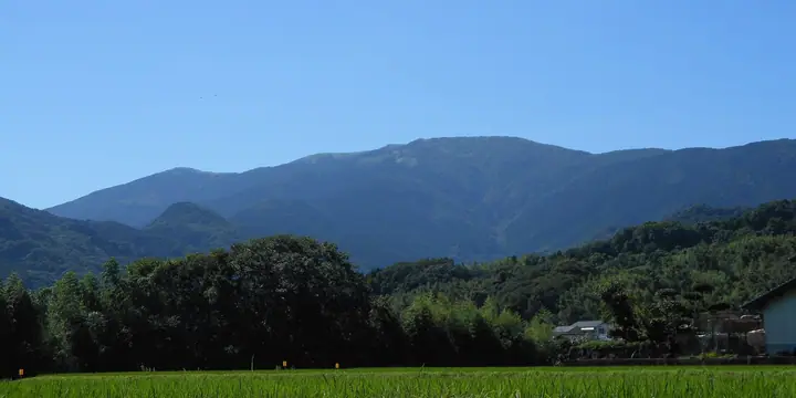
Mount Ten is a 1,046.2-metre peak straddling Saga City (Fuji district), Karatsu City, Taku City, and Ogi City near the centre of Saga Prefecture, crowned with a first-class triangulation point. Its gentle summit is a sweeping grassland known for spring azaleas, and clear days open 360-degree views across the Ariake Sea, Mount Aso, and Unzen to the south and the Genkai Sea to the north. The mountain appears on the Ittō-Sankakuten Hyakumeizan, Kyūshū Hyakumeizan, and Japan 100 Low Mountains (2017) lists.
Mount Ten at a glance
- Weather: The most settled day in the next 7 days is Sun, November 8: clear, gusts up to 5 m/s. Fri, Nov 6: strong wind (gusts up to 16 m/s).
- Route: The shortest is Tenzan Upper Shrine to Mount Tenzan Return: about 1 h 1 min, 2.2 km, about 200 m of climbing.
Mount Ten weather (hourly, 14 days)
Sunrise today 06:39, sunset 17:27
| Tue, 11/3 | Wed, 11/4 | Thu, 11/5 | Fri, 11/6 | Sat, 11/7 | Sun, 11/8 | Mon, 11/9 | Tue, 11/10 | Wed, 11/11 | Thu, 11/12 | Fri, 11/13 | Sat, 11/14 | Sun, 11/15 | Mon, 11/16 | Tue, 11/17 | |||||||||||||||||||||||||||||||||||||||||||||||||||||||||||||||||||||||
|---|---|---|---|---|---|---|---|---|---|---|---|---|---|---|---|---|---|---|---|---|---|---|---|---|---|---|---|---|---|---|---|---|---|---|---|---|---|---|---|---|---|---|---|---|---|---|---|---|---|---|---|---|---|---|---|---|---|---|---|---|---|---|---|---|---|---|---|---|---|---|---|---|---|---|---|---|---|---|---|---|---|---|---|---|---|
| Japan time | 15 | 17 | 19 | 21 | 23 | 1 | 3 | 5 | 7 | 9 | 11 | 13 | 15 | 18 | 21 | 0 | 3 | 6 | 9 | 12 | 15 | 18 | 21 | 0 | 3 | 6 | 9 | 12 | 15 | 18 | 21 | 0 | 3 | 6 | 9 | 12 | 15 | 18 | 21 | 0 | 3 | 6 | 9 | 12 | 15 | 18 | 21 | 0 | 3 | 6 | 9 | 15 | 21 | 3 | 9 | 15 | 21 | 3 | 9 | 15 | 21 | 3 | 9 | 15 | 21 | 3 | 9 | 15 | 21 | 3 | 9 | 15 | 21 | 3 | 9 | 15 | 21 | 3 | 9 | 15 | 21 | 3 | 9 | 15 | |
  |   |   |   | | | | | |   | | | |   | | | | | |   | |   | | |   | | |   |  |  | | | | | | | | | | | | | | | | | | | | | | |   | | | | | |   | | | | | |  | | | | | | | | | | | | | | | | | | | | ||
| Temperature | °C | 12° | 11° | 9° | 9° | 8° | 8° | 7° | 8° | 7° | 10° | 14° | 15° | 15° | 11° | 10° | 11° | 10° | 10° | 13° | 14° | 14° | 14° | 13° | 12° | 11° | 8° | 11° | 13° | 10° | 6° | 6° | 5° | 4° | 3° | 6° | 8° | 8° | 3° | 1° | 1° | 2° | 2° | 8° | 10° | 10° | 7° | 7° | 6° | 7° | 6° | 10° | 11° | 4° | 4° | 8° | 9° | 6° | 5° | 7° | 8° | 2° | 2° | 7° | 10° | 3° | 3° | 10° | 12° | 5° | 3° | 10° | 13° | 9° | 10° | 10° | 12° | 12° | 11° | 11° | 13° | 7° | 5° | 9° | 11° |
| Precipitation | mm | 0.3 | 0.8 | 0.2 | 1.4 | 4.1 | 1.6 | 0.3 | 0.3 | 0.2 | 0.2 | 0.3 | 0.1 | 0.3 | 0.3 | 2.1 | 19 | 10 | 0.2 | 0.7 | 0.1 | ||||||||||||||||||||||||||||||||||||||||||||||||||||||||||||||||
| New snow | cm | ||||||||||||||||||||||||||||||||||||||||||||||||||||||||||||||||||||||||||||||||||||
| Snow depth | cm | 0 | 0 | 0 | 0 | 0 | 0 | 0 | 0 | 0 | 0 | 0 | 0 | 0 | 0 | 0 | 0 | 0 | 0 | 0 | 0 | 0 | 0 | 0 | 0 | 0 | 0 | 0 | 0 | 0 | 0 | 0 | 0 | 0 | 0 | 0 | 0 | 0 | 0 | 0 | 0 | 0 | 0 | 0 | 0 | 0 | 0 | 0 | 0 | 0 | 0 | 0 | 0 | 0 | 0 | 0 | 0 | 0 | 0 | 0 | 0 | 0 | 0 | 0 | 0 | 0 | 0 | 0 | 0 | 0 | 0 | 0 | 0 | 0 | 0 | 0 | 0 | 0 | 0 | 0 | 0 | 0 | 0 | 0 | 0 |
| Wind | m/s | 4 | 3 | 3 | 2 | 2 | 2 | 2 | 2 | 2 | 2 | 2 | 1 | 1 | 2 | 1 | 2 | 1 | 1 | 2 | 4 | 2 | 2 | 3 | 3 | 4 | 3 | 3 | 5 | 5 | 3 | 4 | 5 | 5 | 5 | 5 | 4 | 3 | 2 | 2 | 2 | 2 | 2 | 1 | 1 | 2 | 1 | 1 | 1 | 2 | 2 | 2 | 4 | 2 | 2 | 3 | 5 | 2 | 3 | 4 | 4 | 1 | 0 | 0 | 2 | 1 | 1 | 2 | 3 | 2 | 2 | 2 | 1 | 2 | 3 | 4 | 2 | 1 | 2 | 3 | 4 | 3 | 3 | 3 | 3 |
| Wind gusts | m/s | 12 | 11 | 9 | 9 | 8 | 8 | 8 | 8 | 7 | 6 | 7 | 6 | 4 | 5 | 5 | 5 | 5 | 4 | 8 | 13 | 13 | 10 | 9 | 9 | 10 | 11 | 10 | 15 | 16 | 15 | 11 | 15 | 14 | 14 | 15 | 14 | 12 | 10 | 6 | 6 | 6 | 6 | 5 | 4 | 4 | 4 | 3 | 3 | 7 | 8 | 8 | 10 | 11 | 6 | 9 | 14 | 14 | 12 | 11 | 12 | 10 | 4 | 3 | 7 | 7 | 5 | 8 | 9 | 8 | 6 | 5 | 8 | 6 | 9 | 14 | 14 | 9 | 8 | 10 | 13 | 12 | 11 | 9 | 10 |
| Wind dir. | ↓ | ↓ | ↓ | ↓ | ↓ | ↓ | ↓ | ↓ | ↓ | ↓ | ↓ | ↓ | ↓ | ↓ | ↓ | ↓ | ↓ | ↓ | ↓ | ↓ | ↓ | ↓ | ↓ | ↓ | ↓ | ↓ | ↓ | ↓ | ↓ | ↓ | ↓ | ↓ | ↓ | ↓ | ↓ | ↓ | ↓ | ↓ | ↓ | ↓ | ↓ | ↓ | ↓ | ↓ | ↓ | ↓ | ↓ | ↓ | ↓ | ↓ | ↓ | ↓ | ↓ | ↓ | ↓ | ↓ | ↓ | ↓ | ↓ | ↓ | ↓ | ↓ | ↓ | ↓ | ↓ | ↓ | ↓ | ↓ | ↓ | ↓ | ↓ | ↓ | ↓ | ↓ | ↓ | ↓ | ↓ | ↓ | ↓ | ↓ | ↓ | ↓ | ↓ | ↓ | |
Mount Ten hiking routes
- Tenzan Upper Shrine to Mount Tenzan Return 2.2 km · Ascent 204 m 天山上宮駐車場
- Mount Tenzan and East Peak Return from Amagawa 2.7 km · Ascent 170 m 天川登山口, 天川駐車場
- Mount Tenzan from Nanamagari Pass 7.4 km · Ascent 443 m parking
Hiking times are estimates calculated from the terrain.
Huts, campsites and lodging near Mount Ten
Lodging
- 緑風館
Lists that include Mount Ten
100 Famous Mountains with First-order Triangulation Points · Kyushu 100 Famous Mountains · Elevations of 1003 Mountains of Japan · 1000 Mountains of Japan
Mount Ten facts
- Elevation
- 1,046 m
- Location
- Saga, Saga
33.338914, 130.142927 - Website
- www.city.taku.lg.jp
- Trail Map
- www.city.taku.lg.jp (PDF)
- Access Information
- www.city.ogi.lg.jp
- Wikipedia
- ja.wikipedia.org