
Mount Rishiri
利尻山
Rishirifuji, Hokkaido / Rishiri, Hokkaido · Elevation 1,721 m
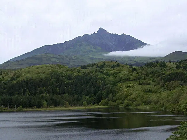
Mount Rishiri is a 1,721 m stratovolcano rising at the center of Rishiri Island off northern Hokkaido. Its graceful, isolated form rising from the sea gives it the name Rishiri-Fuji, and it is Japan’s northernmost independent peak. The whole massif lies within Rishiri-Rebun-Sarobetsu National Park and is known for alpine flora and a long history of climbing. The main routes are Oshidomari and Kutsugata, each taking roughly six hours up and four down. Loose stones cover the Oshidomari route between the ninth station and the summit.
Mount Rishiri at a glance
- Weather: The most settled day in the next 7 days is Mon, November 9: cloudy, gusts up to 12 m/s. Wed, Nov 4, Thu, Nov 5, Fri, Nov 6, Sat, Nov 7, Sun, Nov 8: strong wind (gusts up to 28 m/s).
- Route: The shortest is Mount Rishiri via the Oshidomari Route Out-and-Back: about 8 h 56 min, 13.0 km, about 1,550 m of climbing.
Mount Rishiri weather (hourly, 14 days)
Sunrise today 06:15, sunset 16:22
| Tue, 11/3 | Wed, 11/4 | Thu, 11/5 | Fri, 11/6 | Sat, 11/7 | Sun, 11/8 | Mon, 11/9 | Tue, 11/10 | Wed, 11/11 | Thu, 11/12 | Fri, 11/13 | Sat, 11/14 | Sun, 11/15 | Mon, 11/16 | Tue, 11/17 | |||||||||||||||||||||||||||||||||||||||||||||||||||||||||||||||||||||||
|---|---|---|---|---|---|---|---|---|---|---|---|---|---|---|---|---|---|---|---|---|---|---|---|---|---|---|---|---|---|---|---|---|---|---|---|---|---|---|---|---|---|---|---|---|---|---|---|---|---|---|---|---|---|---|---|---|---|---|---|---|---|---|---|---|---|---|---|---|---|---|---|---|---|---|---|---|---|---|---|---|---|---|---|---|---|
| Japan time | 15 | 17 | 19 | 21 | 23 | 1 | 3 | 5 | 7 | 9 | 11 | 13 | 15 | 18 | 21 | 0 | 3 | 6 | 9 | 12 | 15 | 18 | 21 | 0 | 3 | 6 | 9 | 12 | 15 | 18 | 21 | 0 | 3 | 6 | 9 | 12 | 15 | 18 | 21 | 0 | 3 | 6 | 9 | 12 | 15 | 18 | 21 | 0 | 3 | 6 | 9 | 15 | 21 | 3 | 9 | 15 | 21 | 3 | 9 | 15 | 21 | 3 | 9 | 15 | 21 | 3 | 9 | 15 | 21 | 3 | 9 | 15 | 21 | 3 | 9 | 15 | 21 | 3 | 9 | 15 | 21 | 3 | 9 | 15 | |
  |   |   | |   |   |   | |   | | | | | | | |   | |   |   | | | | | | |   | | |   |   | |   | |   | |   | | | | | |   | | | | | | | | | |   |   | | |   | |  | | |   | | | | | | | | | | | | | | | | | | | | | | | ||
| Temperature | °C | -5° | -5° | -5° | -5° | -4° | -4° | -6° | -7° | -6° | -4° | -4° | -4° | -4° | -3° | -1° | 1° | 1° | 2° | 3° | 4° | 3° | 3° | 2° | 1° | 0° | -1° | 2° | 2° | 2° | -2° | -6° | -8° | -9° | -9° | -9° | -8° | -8° | -8° | -9° | -9° | -9° | -9° | -8° | -8° | -7° | -7° | -7° | -8° | -8° | -8° | -8° | -8° | -9° | -9° | -7° | -6° | -7° | -7° | -6° | -5° | -7° | -7° | -5° | -9° | -10° | -11° | -9° | -6° | -7° | -8° | -4° | -3° | -1° | -1° | 1° | 1° | -1° | -4° | -5° | -6° | -8° | -8° | -7° | -5° |
| Precipitation | mm | 0.2 | 0.4 | 1.6 | 0.4 | 0.1 | 2.9 | 3.7 | 0.5 | 1.2 | 0.3 | 0.9 | 1.1 | 1.1 | 1.0 | 1.2 | 0.8 | 0.7 | 1.2 | 1.1 | 0.8 | 0.7 | 0.4 | 0.5 | 0.2 | 0.2 | 0.2 | 0.2 | 0.2 | 0.2 | 2.2 | 3.3 | 0.5 | 1.9 | 0.6 | 0.4 | 0.1 | 0.2 | 0.4 | 0.9 | 1.5 | 0.3 | 1.3 | 3.6 | 0.9 | 2.1 | 0.3 | 0.4 | |||||||||||||||||||||||||||||||||||||
| New snow | cm | 0.2 | <.1 | 1.1 | <.1 | 0.7 | 1.0 | 1.1 | 1.0 | 1.2 | 0.8 | 0.7 | 1.2 | 1.1 | 0.8 | 0.7 | 0.4 | 0.4 | 0.2 | 0.2 | 0.2 | 0.2 | 0.1 | 0.1 | <.1 | <.1 | <.1 | 2.2 | 2.9 | 0.1 | 1.4 | <.1 | <.1 | <.1 | 0.2 | 0.4 | 0.9 | 1.5 | 0.2 | 0.4 | |||||||||||||||||||||||||||||||||||||||||||||
| Snow depth | cm | 0 | 0 | 0 | 0 | 0 | 0 | 0 | <1 | <1 | <1 | <1 | 0 | 0 | 0 | 0 | 0 | 0 | 0 | 0 | 0 | 0 | 0 | 0 | 0 | 0 | 0 | 0 | 0 | 0 | 0 | 0 | <1 | <1 | 1 | 1 | 2 | 2 | 2 | 2 | 3 | 3 | 3 | 3 | 3 | 3 | 3 | 3 | 3 | 3 | 3 | 3 | 3 | 3 | 3 | 4 | 4 | 4 | 5 | 5 | 4 | 4 | 4 | 3 | 3 | 3 | 3 | 4 | 4 | 4 | 4 | 4 | 3 | 2 | 0 | 0 | 0 | 0 | 0 | 0 | 0 | 0 | 0 | 0 | 0 |
| Wind | m/s | 5 | 5 | 5 | 5 | 4 | 3 | 5 | 4 | 6 | 7 | 5 | 5 | 6 | 6 | 7 | 8 | 8 | 9 | 9 | 8 | 6 | 4 | 2 | 2 | 2 | 3 | 3 | 4 | 8 | 10 | 10 | 11 | 11 | 10 | 10 | 11 | 11 | 12 | 12 | 11 | 11 | 11 | 10 | 9 | 8 | 7 | 6 | 5 | 4 | 4 | 4 | 4 | 3 | 4 | 5 | 3 | 3 | 5 | 3 | 2 | 5 | 4 | 5 | 5 | 5 | 6 | 6 | 8 | 4 | 2 | 4 | 5 | 7 | 6 | 6 | 7 | 4 | 4 | 5 | 5 | 5 | 6 | 3 | 4 |
| Wind gusts | m/s | 15 | 13 | 13 | 15 | 14 | 11 | 12 | 12 | 14 | 18 | 17 | 14 | 15 | 16 | 18 | 20 | 22 | 23 | 23 | 23 | 21 | 15 | 10 | 7 | 5 | 7 | 10 | 14 | 20 | 26 | 27 | 28 | 29 | 27 | 26 | 27 | 28 | 30 | 30 | 29 | 28 | 28 | 27 | 26 | 24 | 21 | 17 | 14 | 12 | 10 | 10 | 12 | 11 | 9 | 13 | 15 | 9 | 13 | 11 | 10 | 11 | 13 | 13 | 14 | 14 | 16 | 17 | 21 | 19 | 10 | 10 | 15 | 18 | 18 | 20 | 19 | 16 | 12 | 12 | 13 | 14 | 15 | 15 | 12 |
| Wind dir. | ↓ | ↓ | ↓ | ↓ | ↓ | ↓ | ↓ | ↓ | ↓ | ↓ | ↓ | ↓ | ↓ | ↓ | ↓ | ↓ | ↓ | ↓ | ↓ | ↓ | ↓ | ↓ | ↓ | ↓ | ↓ | ↓ | ↓ | ↓ | ↓ | ↓ | ↓ | ↓ | ↓ | ↓ | ↓ | ↓ | ↓ | ↓ | ↓ | ↓ | ↓ | ↓ | ↓ | ↓ | ↓ | ↓ | ↓ | ↓ | ↓ | ↓ | ↓ | ↓ | ↓ | ↓ | ↓ | ↓ | ↓ | ↓ | ↓ | ↓ | ↓ | ↓ | ↓ | ↓ | ↓ | ↓ | ↓ | ↓ | ↓ | ↓ | ↓ | ↓ | ↓ | ↓ | ↓ | ↓ | ↓ | ↓ | ↓ | ↓ | ↓ | ↓ | ↓ | ↓ | |
Mount Rishiri live cameras
Mount Rishiri hiking routes
- Mount Rishiri via the Oshidomari Route Out-and-Back 13.0 km · Ascent 1,549 m parking
- Mount Rishiri Oshidomari Route Return 16.7 km · Ascent 1,721 m Rishirifuji Onsen (parking)
Hiking times are estimates calculated from the terrain.
Huts, campsites and lodging near Mount Rishiri
Mountain huts
Lists that include Mount Rishiri
100 Famous Japanese Mountains · Japan 200 Famous Mountains · Japan's 300 Famous Mountains · 100 Famous Mountains of Flowers · New 100 Famous Flower Mountains · New Japan 100 Famous Mountains · 100 Fujis of Japan · Hokkaido 100 Famous Mountains · 100 Selected Island Mountains · Elevations of 1003 Mountains of Japan · 1000 Mountains of Japan
Mount Rishiri facts
- Also known as
- 利尻富士 · 利尻岳
- Elevation
- 1,721 m
- Location
- Rishirifuji, Hokkaido / Rishiri, Hokkaido
45.180430, 141.241377 - National Park
- 利尻礼文サロベツ国立公園
- Volcano
- Active volcano (利尻山)
- Website
- www.town.rishirifuji.hokkaido.jp
- Trail Map
- www.town.rishirifuji.hokkaido.jp
- Access Information
- www.town.rishirifuji.hokkaido.jp
- Wikipedia
- ja.wikipedia.org