
Mount Chokan
長官山
Rishirifuji, Hokkaido · Elevation 1,218 m
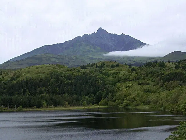
Mount Chokan is a 1,218.3 m peak in Rishirifuji Town on Rishiri Island, Hokkaido, marking the eighth station of the popular Oshidomari route up Mt. Rishiri (1,721 m), the highest peak on the island. Within Rishiri-Rebun-Sarobetsu National Park, the name is said to come from a 1933 ascent by the then-governor of Hokkaido. Its summit holds a primary triangulation marker named "Rishiri-zan," making this the northernmost peak in the Ittosankakuten Hyakumeizan list.. Here the Rishiri summit comes into view for the first time on the route, followed by a short descent to the saddle with the emergency hut.
Mount Chokan at a glance
- Weather: The most settled day in the next 7 days is Mon, November 9: cloudy, gusts up to 12 m/s. Wed, Nov 4, Thu, Nov 5, Fri, Nov 6, Sat, Nov 7, Sun, Nov 8: strong wind (gusts up to 28 m/s).
- Route: The shortest is Mount Rishiri via the Oshidomari Route Out-and-Back: about 8 h 56 min, 13.0 km, about 1,550 m of climbing.
Mount Chokan weather (hourly, 14 days)
Sunrise today 06:15, sunset 16:22
| Tue, 11/3 | Wed, 11/4 | Thu, 11/5 | Fri, 11/6 | Sat, 11/7 | Sun, 11/8 | Mon, 11/9 | Tue, 11/10 | Wed, 11/11 | Thu, 11/12 | Fri, 11/13 | Sat, 11/14 | Sun, 11/15 | Mon, 11/16 | Tue, 11/17 | |||||||||||||||||||||||||||||||||||||||||||||||||||||||||||||||||||||||
|---|---|---|---|---|---|---|---|---|---|---|---|---|---|---|---|---|---|---|---|---|---|---|---|---|---|---|---|---|---|---|---|---|---|---|---|---|---|---|---|---|---|---|---|---|---|---|---|---|---|---|---|---|---|---|---|---|---|---|---|---|---|---|---|---|---|---|---|---|---|---|---|---|---|---|---|---|---|---|---|---|---|---|---|---|---|
| Japan time | 15 | 17 | 19 | 21 | 23 | 1 | 3 | 5 | 7 | 9 | 11 | 13 | 15 | 18 | 21 | 0 | 3 | 6 | 9 | 12 | 15 | 18 | 21 | 0 | 3 | 6 | 9 | 12 | 15 | 18 | 21 | 0 | 3 | 6 | 9 | 12 | 15 | 18 | 21 | 0 | 3 | 6 | 9 | 12 | 15 | 18 | 21 | 0 | 3 | 6 | 9 | 15 | 21 | 3 | 9 | 15 | 21 | 3 | 9 | 15 | 21 | 3 | 9 | 15 | 21 | 3 | 9 | 15 | 21 | 3 | 9 | 15 | 21 | 3 | 9 | 15 | 21 | 3 | 9 | 15 | 21 | 3 | 9 | 15 | |
  |   |   | |   |   |   | |   | | | | | | | |   | |   |   | | | | | | |   | | |   |   | |   | |   | |   | | | | | |   | | | | | | | | | |   |   | | |   | |  | | |   | | | | | | | | | | | | | | | | | | | | | | | ||
| Temperature | °C | -2° | -2° | -1° | -1° | -1° | -1° | -3° | -4° | -3° | -1° | -1° | -1° | 0° | 0° | 2° | 4° | 5° | 5° | 6° | 7° | 7° | 6° | 5° | 4° | 3° | 2° | 5° | 5° | 5° | 1° | -3° | -5° | -6° | -6° | -6° | -5° | -4° | -5° | -6° | -6° | -6° | -6° | -5° | -5° | -4° | -3° | -4° | -4° | -5° | -5° | -4° | -5° | -6° | -6° | -4° | -3° | -4° | -4° | -2° | -2° | -4° | -4° | -2° | -5° | -7° | -8° | -6° | -3° | -4° | -5° | -1° | 1° | 2° | 3° | 4° | 4° | 2° | -1° | -2° | -3° | -5° | -5° | -4° | -2° |
| Precipitation | mm | 0.2 | 0.4 | 1.6 | 0.4 | 0.1 | 2.9 | 3.7 | 0.5 | 1.2 | 0.3 | 0.9 | 1.1 | 1.1 | 1.0 | 1.2 | 0.8 | 0.7 | 1.2 | 1.1 | 0.8 | 0.7 | 0.4 | 0.5 | 0.2 | 0.2 | 0.2 | 0.2 | 0.2 | 0.2 | 2.2 | 3.3 | 0.5 | 1.9 | 0.6 | 0.4 | 0.1 | 0.2 | 0.4 | 0.9 | 1.5 | 0.3 | 1.3 | 3.6 | 0.9 | 2.1 | 0.3 | 0.4 | |||||||||||||||||||||||||||||||||||||
| New snow | cm | 0.2 | <.1 | 1.1 | <.1 | 0.7 | 1.0 | 1.1 | 1.0 | 1.2 | 0.8 | 0.7 | 1.2 | 1.1 | 0.8 | 0.7 | 0.4 | 0.4 | 0.2 | 0.2 | 0.2 | 0.2 | 0.1 | 0.1 | <.1 | <.1 | <.1 | 2.2 | 2.9 | 0.1 | 1.4 | <.1 | <.1 | <.1 | 0.2 | 0.4 | 0.9 | 1.5 | 0.2 | 0.4 | |||||||||||||||||||||||||||||||||||||||||||||
| Snow depth | cm | 0 | 0 | 0 | 0 | 0 | 0 | 0 | <1 | <1 | <1 | <1 | 0 | 0 | 0 | 0 | 0 | 0 | 0 | 0 | 0 | 0 | 0 | 0 | 0 | 0 | 0 | 0 | 0 | 0 | 0 | 0 | <1 | <1 | 1 | 1 | 2 | 2 | 2 | 2 | 3 | 3 | 3 | 3 | 3 | 3 | 3 | 3 | 3 | 3 | 3 | 3 | 3 | 3 | 3 | 4 | 4 | 4 | 5 | 5 | 4 | 4 | 4 | 3 | 3 | 3 | 3 | 4 | 4 | 4 | 4 | 4 | 3 | 2 | 0 | 0 | 0 | 0 | 0 | 0 | 0 | 0 | 0 | 0 | 0 |
| Wind | m/s | 5 | 5 | 5 | 5 | 4 | 3 | 5 | 4 | 6 | 7 | 5 | 5 | 6 | 6 | 7 | 8 | 8 | 9 | 9 | 8 | 6 | 4 | 2 | 2 | 2 | 3 | 3 | 4 | 8 | 10 | 10 | 11 | 11 | 10 | 10 | 11 | 11 | 12 | 12 | 11 | 11 | 11 | 10 | 9 | 8 | 7 | 6 | 5 | 4 | 4 | 4 | 4 | 3 | 4 | 5 | 3 | 3 | 5 | 3 | 2 | 5 | 4 | 5 | 5 | 5 | 6 | 6 | 8 | 4 | 2 | 4 | 5 | 7 | 6 | 6 | 7 | 4 | 4 | 5 | 5 | 5 | 6 | 3 | 4 |
| Wind gusts | m/s | 15 | 13 | 13 | 15 | 14 | 11 | 12 | 12 | 14 | 18 | 17 | 14 | 15 | 16 | 18 | 20 | 22 | 23 | 23 | 23 | 21 | 15 | 10 | 7 | 5 | 7 | 10 | 14 | 20 | 26 | 27 | 28 | 29 | 27 | 26 | 27 | 28 | 30 | 30 | 29 | 28 | 28 | 27 | 26 | 24 | 21 | 17 | 14 | 12 | 10 | 10 | 12 | 11 | 9 | 13 | 15 | 9 | 13 | 11 | 10 | 11 | 13 | 13 | 14 | 14 | 16 | 17 | 21 | 19 | 10 | 10 | 15 | 18 | 18 | 20 | 19 | 16 | 12 | 12 | 13 | 14 | 15 | 15 | 12 |
| Wind dir. | ↓ | ↓ | ↓ | ↓ | ↓ | ↓ | ↓ | ↓ | ↓ | ↓ | ↓ | ↓ | ↓ | ↓ | ↓ | ↓ | ↓ | ↓ | ↓ | ↓ | ↓ | ↓ | ↓ | ↓ | ↓ | ↓ | ↓ | ↓ | ↓ | ↓ | ↓ | ↓ | ↓ | ↓ | ↓ | ↓ | ↓ | ↓ | ↓ | ↓ | ↓ | ↓ | ↓ | ↓ | ↓ | ↓ | ↓ | ↓ | ↓ | ↓ | ↓ | ↓ | ↓ | ↓ | ↓ | ↓ | ↓ | ↓ | ↓ | ↓ | ↓ | ↓ | ↓ | ↓ | ↓ | ↓ | ↓ | ↓ | ↓ | ↓ | ↓ | ↓ | ↓ | ↓ | ↓ | ↓ | ↓ | ↓ | ↓ | ↓ | ↓ | ↓ | ↓ | ↓ | |
Mount Chokan hiking routes
- Mount Rishiri via the Oshidomari Route Out-and-Back 13.0 km · Ascent 1,549 m parking
- Mount Rishiri Oshidomari Route Return 16.7 km · Ascent 1,721 m Rishirifuji Onsen (parking)
Hiking times are estimates calculated from the terrain.
Huts, campsites and lodging near Mount Chokan
Mountain huts
Lodging
- うに御殿
Lists that include Mount Chokan
Mount Chokan facts
- Also known as
- 八合目
- Elevation
- 1,218 m
- Location
- Rishirifuji, Hokkaido
45.193969, 141.238394 - National Park
- 利尻礼文サロベツ国立公園
- Volcano
- Active volcano (利尻山)
- Website
- www.town.rishirifuji.hokkaido.jp
- Wikipedia
- ja.wikipedia.org