
Mount Rakko
楽古岳
Urakawa, Hokkaido · Elevation 1,472 m
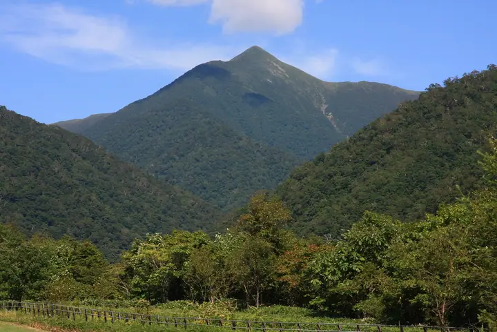
Mount Rakko is a 1,472 m peak on the border between Urakawa and Hiroo towns in southern Hokkaido, standing at the southernmost end of the main ridge of the Hidaka Range. The name comes from the Rakko River that drains its slopes, derived in Ainu either from 'rak-ko' (a fire-extinguishing river) or from 'rakko' (sea otter). Its summit forms a striking three-sided pyramid topped with a first-class triangulation point known as 'Mensha-dake', and on clear days commands a panorama from the Daisetsu massif in the north to Cape Erimo in the south. Reached in about four hours from the Menashunbetsu River trail on the Hidaka side, it lies within Hidaka-Sanmyaku-Erimo-Tokachi National Park designated in 2024 and is one of the 100 Famous Mountains of Hokkaido.
Mount Rakko at a glance
- Weather: The most settled day in the next 7 days is Mon, November 9: clear, gusts up to 16 m/s. Wed, Nov 4, Fri, Nov 6, Sat, Nov 7, Sun, Nov 8, Mon, Nov 9: strong wind (gusts up to 28 m/s).
Mount Rakko weather (hourly, 14 days)
Sunrise today 06:02, sunset 16:20
| Tue, 11/3 | Wed, 11/4 | Thu, 11/5 | Fri, 11/6 | Sat, 11/7 | Sun, 11/8 | Mon, 11/9 | Tue, 11/10 | Wed, 11/11 | Thu, 11/12 | Fri, 11/13 | Sat, 11/14 | Sun, 11/15 | Mon, 11/16 | Tue, 11/17 | |||||||||||||||||||||||||||||||||||||||||||||||||||||||||||||||||||||||
|---|---|---|---|---|---|---|---|---|---|---|---|---|---|---|---|---|---|---|---|---|---|---|---|---|---|---|---|---|---|---|---|---|---|---|---|---|---|---|---|---|---|---|---|---|---|---|---|---|---|---|---|---|---|---|---|---|---|---|---|---|---|---|---|---|---|---|---|---|---|---|---|---|---|---|---|---|---|---|---|---|---|---|---|---|---|
| Japan time | 21 | 23 | 1 | 3 | 5 | 7 | 9 | 11 | 13 | 15 | 17 | 19 | 21 | 0 | 3 | 6 | 9 | 12 | 15 | 18 | 21 | 0 | 3 | 6 | 9 | 12 | 15 | 18 | 21 | 0 | 3 | 6 | 9 | 12 | 15 | 18 | 21 | 0 | 3 | 6 | 9 | 12 | 15 | 18 | 21 | 0 | 3 | 6 | 9 | 12 | 15 | 21 | 3 | 9 | 15 | 21 | 3 | 9 | 15 | 21 | 3 | 9 | 15 | 21 | 3 | 9 | 15 | 21 | 3 | 9 | 15 | 21 | 3 | 9 | 15 | 21 | 3 | 9 | 15 | 21 | 3 | 9 | 15 | 21 | |
 | |   |   |   |  | | | | |  | | | |   |   |   | | |   | | | | | | |   | | | |   |   |   |   | | | | | | | |   | | | | | | | | | |   | | | | | | |   | | |   | | |  | | | | | | | | |   | |   | | | |   | | | |  | ||
| Temperature | °C | -5° | -6° | -6° | -4° | -4° | -4° | -1° | 0° | 1° | 0° | -6° | -7° | -7° | -6° | -4° | -1° | 3° | 3° | 3° | 2° | 2° | 2° | 2° | 2° | 3° | 4° | 5° | 2° | -2° | -4° | -6° | -7° | -5° | -6° | -7° | -7° | -7° | -8° | -8° | -9° | -6° | -4° | -6° | -8° | -9° | -10° | -10° | -10° | -6° | -4° | -6° | -11° | -12° | -5° | -5° | -7° | -8° | -7° | -5° | -8° | -8° | -4° | -4° | -10° | -12° | -7° | -6° | -11° | -11° | -4° | -3° | -9° | -8° | 0° | -1° | -3° | -3° | 1° | -2° | -6° | -10° | -5° | -3° | -9° |
| Precipitation | mm | 1.6 | 0.6 | 0.6 | 3.3 | 3.3 | 1.6 | 1.1 | 2.5 | 5.0 | 3.0 | 6 | 0.9 | 0.3 | 1.0 | 0.4 | 0.2 | 0.6 | 0.4 | 0.8 | 2.0 | 1.7 | 0.3 | 1.7 | 6 | 2.2 | 0.2 | 0.1 | 1.2 | 0.4 | 0.1 | 1.0 | 1.1 | 0.3 | |||||||||||||||||||||||||||||||||||||||||||||||||||
| New snow | cm | 1.3 | 0.3 | <.1 | 0.5 | 0.4 | 0.8 | 2.0 | 1.7 | 0.3 | <.1 | 1.7 | 5.6 | 2.2 | 0.2 | <.1 | 0.2 | <.1 | |||||||||||||||||||||||||||||||||||||||||||||||||||||||||||||||||||
| Snow depth | cm | 0 | 0 | 0 | <1 | <1 | <1 | <1 | 0 | 0 | 0 | 0 | 0 | 0 | 0 | 0 | 0 | 0 | 0 | 0 | 0 | 0 | 0 | 0 | 0 | 0 | 0 | 0 | 0 | 0 | 0 | 0 | <1 | <1 | 2 | 3 | 3 | 3 | 3 | 3 | 3 | 3 | 3 | 2 | 2 | 2 | 2 | 2 | 2 | 2 | 2 | 2 | 2 | 2 | 2 | 2 | 2 | 3 | 7 | 8 | 8 | 7 | 7 | 7 | 6 | 6 | 6 | 6 | 6 | 6 | 6 | 6 | 6 | 6 | 5 | 4 | 3 | 3 | 2 | 1 | 1 | 1 | 1 | 1 | 1 |
| Wind | m/s | 5 | 3 | 3 | 5 | 5 | 6 | 6 | 5 | 5 | 3 | 2 | 2 | 1 | 2 | 2 | 2 | 2 | 1 | 1 | 1 | 1 | 2 | 3 | 2 | 0 | 3 | 6 | 9 | 10 | 9 | 9 | 8 | 9 | 7 | 7 | 11 | 10 | 10 | 10 | 10 | 9 | 10 | 7 | 5 | 4 | 3 | 3 | 3 | 4 | 5 | 4 | 2 | 2 | 2 | 2 | 3 | 5 | 4 | 2 | 0 | 2 | 3 | 3 | 2 | 3 | 4 | 2 | 2 | 1 | 1 | 1 | 1 | 2 | 2 | 3 | 2 | 1 | 2 | 2 | 1 | 1 | 0 | 2 | 2 |
| Wind gusts | m/s | 14 | 15 | 12 | 18 | 16 | 18 | 18 | 18 | 16 | 14 | 11 | 7 | 7 | 8 | 8 | 8 | 9 | 9 | 7 | 6 | 4 | 6 | 7 | 8 | 5 | 10 | 17 | 25 | 28 | 28 | 28 | 27 | 27 | 27 | 26 | 32 | 32 | 29 | 29 | 28 | 28 | 27 | 26 | 20 | 16 | 12 | 11 | 11 | 13 | 16 | 15 | 14 | 9 | 7 | 8 | 8 | 16 | 17 | 12 | 5 | 8 | 10 | 14 | 13 | 10 | 12 | 13 | 10 | 8 | 4 | 8 | 6 | 8 | 9 | 12 | 11 | 7 | 6 | 8 | 5 | 4 | 4 | 9 | 8 |
| Wind dir. | ↓ | ↓ | ↓ | ↓ | ↓ | ↓ | ↓ | ↓ | ↓ | ↓ | ↓ | ↓ | ↓ | ↓ | ↓ | ↓ | ↓ | ↓ | ↓ | ↓ | ↓ | ↓ | ↓ | ↓ | ↓ | ↓ | ↓ | ↓ | ↓ | ↓ | ↓ | ↓ | ↓ | ↓ | ↓ | ↓ | ↓ | ↓ | ↓ | ↓ | ↓ | ↓ | ↓ | ↓ | ↓ | ↓ | ↓ | ↓ | ↓ | ↓ | ↓ | ↓ | ↓ | ↓ | ↓ | ↓ | ↓ | ↓ | ↓ | ↓ | ↓ | ↓ | ↓ | ↓ | ↓ | ↓ | ↓ | ↓ | ↓ | ↓ | ↓ | ↓ | ↓ | ↓ | ↓ | ↓ | ↓ | ↓ | ↓ | ↓ | ↓ | ↓ | ↓ | ↓ | |
Huts, campsites and lodging near Mount Rakko
Mountain huts
Lists that include Mount Rakko
Hokkaido 100 Famous Mountains · Elevations of 1003 Mountains of Japan · 1000 Mountains of Japan
Mount Rakko facts
- Elevation
- 1,472 m
- Location
- Urakawa, Hokkaido
42.272514, 143.111129 - National Park
- 日高山脈襟裳十勝国立公園
- Website
- hidakasanmyaku-sangakucenter.jp
- Access Information
- www.hidaka.pref.hokkaido.lg.jp
- Wikipedia
- ja.wikipedia.org