
Mount Outo
皇踏山
Tonoshō-chō, Kagawa · Elevation 394 m
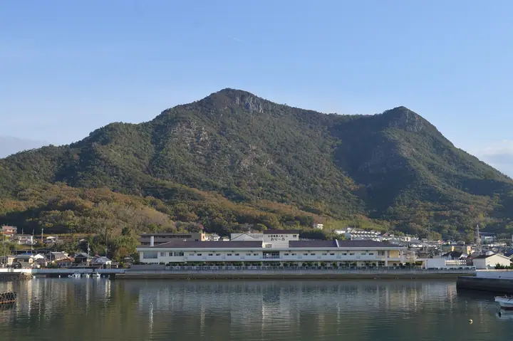
A 394-meter twin-peak hill in western Shodoshima, in Tonosho Town, Shozu District, Kagawa Prefecture, lying within a special protection zone of Setonaikai National Park. The name preserves a legend that Emperor Ojin planted ibuki cypresses on its slopes. A medieval hilltop fortress crowned the summit, leaving stone walls that run for some 1.5 kilometers along the ridge. Its two humps form a distinctive silhouette from Tonosho Harbor; the maintained hiking trail visits several observation points overlooking Angel Road and as far as the mountains of mainland Honshu. The peak was selected in 2004 for Kagawa's 100 Green Spots and in 2016 for the 100 Famous Island Mountains.
Mount Outo at a glance
- Weather: The most settled day in the next 7 days is Thu, November 5: cloudy, gusts up to 4 m/s.
Mount Outo weather (hourly, 14 days)
Sunrise today 06:25, sunset 17:09
| Tue, 11/3 | Wed, 11/4 | Thu, 11/5 | Fri, 11/6 | Sat, 11/7 | Sun, 11/8 | Mon, 11/9 | Tue, 11/10 | Wed, 11/11 | Thu, 11/12 | Fri, 11/13 | Sat, 11/14 | Sun, 11/15 | Mon, 11/16 | Tue, 11/17 | |||||||||||||||||||||||||||||||||||||||||||||||||||||||||||||||||||||||
|---|---|---|---|---|---|---|---|---|---|---|---|---|---|---|---|---|---|---|---|---|---|---|---|---|---|---|---|---|---|---|---|---|---|---|---|---|---|---|---|---|---|---|---|---|---|---|---|---|---|---|---|---|---|---|---|---|---|---|---|---|---|---|---|---|---|---|---|---|---|---|---|---|---|---|---|---|---|---|---|---|---|---|---|---|---|
| Japan time | 15 | 17 | 19 | 21 | 23 | 1 | 3 | 5 | 7 | 9 | 11 | 13 | 15 | 18 | 21 | 0 | 3 | 6 | 9 | 12 | 15 | 18 | 21 | 0 | 3 | 6 | 9 | 12 | 15 | 18 | 21 | 0 | 3 | 6 | 9 | 12 | 15 | 18 | 21 | 0 | 3 | 6 | 9 | 12 | 15 | 18 | 21 | 0 | 3 | 6 | 9 | 15 | 21 | 3 | 9 | 15 | 21 | 3 | 9 | 15 | 21 | 3 | 9 | 15 | 21 | 3 | 9 | 15 | 21 | 3 | 9 | 15 | 21 | 3 | 9 | 15 | 21 | 3 | 9 | 15 | 21 | 3 | 9 | 15 | |
  | |   |   |   | | |   |   | | | | |   | | | | |   | | | |   | | |  |  | | | | | | | | | | | | | | | | | | | | | | | | | | |   | | | | | |   | |  | | | | | | | | | | | | | | | | | |   | |  | | | ||
| Temperature | °C | 17° | 17° | 16° | 15° | 15° | 14° | 14° | 14° | 14° | 14° | 15° | 16° | 17° | 17° | 17° | 15° | 16° | 15° | 16° | 16° | 17° | 17° | 18° | 17° | 17° | 16° | 16° | 17° | 18° | 16° | 14° | 12° | 12° | 11° | 11° | 13° | 13° | 13° | 12° | 12° | 11° | 11° | 11° | 13° | 14° | 14° | 14° | 13° | 13° | 13° | 13° | 15° | 13° | 12° | 13° | 16° | 12° | 10° | 10° | 13° | 11° | 10° | 10° | 12° | 13° | 12° | 12° | 13° | 11° | 10° | 11° | 13° | 13° | 13° | 15° | 17° | 16° | 16° | 15° | 17° | 12° | 10° | 10° | 12° |
| Precipitation | mm | 0.1 | 0.4 | 0.1 | 1.1 | 0.8 | 1.9 | 0.4 | 0.3 | 0.1 | 1.5 | 0.3 | 0.2 | 2.7 | 0.1 | 0.2 | |||||||||||||||||||||||||||||||||||||||||||||||||||||||||||||||||||||
| New snow | cm | ||||||||||||||||||||||||||||||||||||||||||||||||||||||||||||||||||||||||||||||||||||
| Snow depth | cm | 0 | 0 | 0 | 0 | 0 | 0 | 0 | 0 | 0 | 0 | 0 | 0 | 0 | 0 | 0 | 0 | 0 | 0 | 0 | 0 | 0 | 0 | 0 | 0 | 0 | 0 | 0 | 0 | 0 | 0 | 0 | 0 | 0 | 0 | 0 | 0 | 0 | 0 | 0 | 0 | 0 | 0 | 0 | 0 | 0 | 0 | 0 | 0 | 0 | 0 | 0 | 0 | 0 | 0 | 0 | 0 | 0 | 0 | 0 | 0 | 0 | 0 | 0 | 0 | 0 | 0 | 0 | 0 | 0 | 0 | 0 | 0 | 0 | 0 | 0 | 0 | 0 | 0 | 0 | 0 | 0 | 0 | 0 | 0 |
| Wind | m/s | 4 | 5 | 4 | 6 | 5 | 4 | 4 | 4 | 5 | 5 | 4 | 4 | 3 | 3 | 4 | 3 | 2 | 2 | 1 | 2 | 1 | 4 | 3 | 5 | 7 | 7 | 8 | 8 | 9 | 10 | 9 | 7 | 8 | 7 | 8 | 6 | 6 | 6 | 5 | 4 | 4 | 2 | 3 | 2 | 2 | 2 | 4 | 2 | 3 | 3 | 5 | 4 | 5 | 4 | 6 | 7 | 8 | 9 | 6 | 7 | 5 | 2 | 2 | 4 | 7 | 5 | 5 | 7 | 4 | 3 | 2 | 2 | 2 | 2 | 2 | 0 | 3 | 5 | 6 | 8 | 7 | 6 | 3 | 1 |
| Wind gusts | m/s | 6 | 8 | 7 | 9 | 8 | 7 | 7 | 6 | 7 | 8 | 8 | 7 | 6 | 5 | 6 | 7 | 5 | 5 | 4 | 3 | 3 | 5 | 6 | 7 | 10 | 10 | 11 | 11 | 13 | 14 | 15 | 13 | 11 | 12 | 11 | 11 | 9 | 9 | 9 | 8 | 6 | 6 | 5 | 5 | 4 | 4 | 6 | 6 | 5 | 5 | 8 | 8 | 8 | 7 | 9 | 11 | 12 | 13 | 13 | 10 | 10 | 7 | 5 | 6 | 11 | 10 | 8 | 10 | 10 | 7 | 5 | 5 | 5 | 4 | 5 | 4 | 4 | 7 | 10 | 11 | 13 | 10 | 9 | 5 |
| Wind dir. | ↓ | ↓ | ↓ | ↓ | ↓ | ↓ | ↓ | ↓ | ↓ | ↓ | ↓ | ↓ | ↓ | ↓ | ↓ | ↓ | ↓ | ↓ | ↓ | ↓ | ↓ | ↓ | ↓ | ↓ | ↓ | ↓ | ↓ | ↓ | ↓ | ↓ | ↓ | ↓ | ↓ | ↓ | ↓ | ↓ | ↓ | ↓ | ↓ | ↓ | ↓ | ↓ | ↓ | ↓ | ↓ | ↓ | ↓ | ↓ | ↓ | ↓ | ↓ | ↓ | ↓ | ↓ | ↓ | ↓ | ↓ | ↓ | ↓ | ↓ | ↓ | ↓ | ↓ | ↓ | ↓ | ↓ | ↓ | ↓ | ↓ | ↓ | ↓ | ↓ | ↓ | ↓ | ↓ | ↓ | ↓ | ↓ | ↓ | ↓ | ↓ | ↓ | ↓ | ↓ | |
Huts, campsites and lodging near Mount Outo
Lodging
- Asahiya Ryokan
- ホテルグリーンプラザ小豆島
- オーキドホテル
- 天空ホテル海盧
- 入船
Lists that include Mount Outo
Mount Outo facts
- Elevation
- 394 m
- Location
- Tonoshō-chō, Kagawa
34.499921, 134.188181 - National Park
- 瀬戸内海国立公園
- Website
- www.town.tonosho.kagawa.jp
- Trail Map
- www.town.tonosho.kagawa.jp (PDF)
- Wikipedia
- ja.wikipedia.org