
Mount Ōtakine
大滝根山
Tamura, Fukushima · Elevation 1,193 m
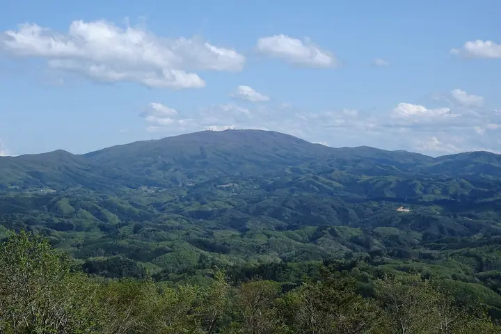
Mount Ōtakine is a 1,192.5 m peak straddling Tamura City and Kawauchi Village in Futaba District, Fukushima Prefecture, the highest summit of the Abukuma Highlands. The limestone massif holds extensive karst topography, including Japan's renowned Abukumadō and Irimizu show caves on its lower flanks. It is listed in the Nihon Sanbyaku Meizan, the Hana no Hyakumeizan, the Shin Hana no Hyakumeizan, and the Utsukushima 100 Meizan, and falls within Abukuma-Kōchi Prefectural Natural Park. A Japan Air Self-Defense Force radar station (the Ōtakine Bunton Base) occupies the immediate summit, so reaching the first-order triangulation marker requires prior permission from the base. The standard ascents climb from the Ōgoe trailhead or the Sendai-daira trailhead on the west side — each a 1.5–2 hour one-way climb — and pass the clear stream of Onigorō Gorge along with several waterfalls including Antei-no-Taki and Shidareyanagi-no-Taki.
Mount Ōtakine at a glance
- Weather: The most settled day in the next 7 days is Wed, November 4: clear, gusts up to 9 m/s. Fri, Nov 6, Sat, Nov 7, Sun, Nov 8: strong wind (gusts up to 21 m/s).
Mount Ōtakine weather (hourly, 14 days)
Sunrise today 06:03, sunset 16:39
| Tue, 11/3 | Wed, 11/4 | Thu, 11/5 | Fri, 11/6 | Sat, 11/7 | Sun, 11/8 | Mon, 11/9 | Tue, 11/10 | Wed, 11/11 | Thu, 11/12 | Fri, 11/13 | Sat, 11/14 | Sun, 11/15 | Mon, 11/16 | Tue, 11/17 | |||||||||||||||||||||||||||||||||||||||||||||||||||||||||||||||||||||||
|---|---|---|---|---|---|---|---|---|---|---|---|---|---|---|---|---|---|---|---|---|---|---|---|---|---|---|---|---|---|---|---|---|---|---|---|---|---|---|---|---|---|---|---|---|---|---|---|---|---|---|---|---|---|---|---|---|---|---|---|---|---|---|---|---|---|---|---|---|---|---|---|---|---|---|---|---|---|---|---|---|---|---|---|---|---|
| Japan time | 21 | 23 | 1 | 3 | 5 | 7 | 9 | 11 | 13 | 15 | 17 | 19 | 21 | 0 | 3 | 6 | 9 | 12 | 15 | 18 | 21 | 0 | 3 | 6 | 9 | 12 | 15 | 18 | 21 | 0 | 3 | 6 | 9 | 12 | 15 | 18 | 21 | 0 | 3 | 6 | 9 | 12 | 15 | 18 | 21 | 0 | 3 | 6 | 9 | 12 | 15 | 21 | 3 | 9 | 15 | 21 | 3 | 9 | 15 | 21 | 3 | 9 | 15 | 21 | 3 | 9 | 15 | 21 | 3 | 9 | 15 | 21 | 3 | 9 | 15 | 21 | 3 | 9 | 15 | 21 | 3 | 9 | 15 | 21 | |
 | | | | |  | | |   | |   | | |   | | |   | | | | | | |   | |   | |   | | |   | |   | | |  | | | | | | | | | | | | | | | | | | | |   | | | | | | | |  | |   | | | | | | | | | | | | | |   | | | | | ||
| Temperature | °C | 2° | 1° | 1° | 2° | 1° | 2° | 8° | 10° | 10° | 8° | 6° | 6° | 6° | 5° | 6° | 7° | 7° | 9° | 10° | 9° | 8° | 8° | 7° | 7° | 10° | 12° | 11° | 8° | 6° | 4° | 3° | 2° | 3° | 3° | 2° | 0° | -1° | 0° | 0° | 0° | 2° | 4° | 3° | 0° | 0° | 0° | 0° | 0° | 0° | 2° | 2° | 0° | 1° | 2° | 3° | 0° | 1° | 1° | 6° | 0° | -1° | 3° | 5° | 1° | 1° | 5° | 4° | -2° | -4° | 2° | 6° | 0° | -1° | 7° | 10° | 6° | 7° | 11° | 8° | 1° | -2° | 1° | 4° | -1° |
| Precipitation | mm | 3.8 | 7 | 8 | 9 | 7 | 0.7 | 0.2 | 0.6 | 0.1 | 0.1 | 0.2 | 1.0 | 6 | 0.8 | 0.2 | 0.3 | 0.9 | 0.1 | 2.1 | 20 | 0.1 | 0.4 | ||||||||||||||||||||||||||||||||||||||||||||||||||||||||||||||
| New snow | cm | ||||||||||||||||||||||||||||||||||||||||||||||||||||||||||||||||||||||||||||||||||||
| Snow depth | cm | 0 | 0 | 0 | 0 | 0 | 0 | 0 | 0 | 0 | 0 | 0 | 0 | 0 | 0 | 0 | 0 | 0 | 0 | 0 | 0 | 0 | 0 | 0 | 0 | 0 | 0 | 0 | 0 | 0 | 0 | 0 | 0 | 0 | 0 | 0 | 0 | 0 | 0 | 0 | 0 | 0 | 0 | 0 | 0 | 0 | 0 | 0 | 0 | 0 | 0 | 0 | 0 | 0 | 0 | 0 | 0 | 0 | 0 | 0 | 0 | 0 | 0 | 0 | 0 | 0 | 0 | 0 | 0 | 0 | 0 | 0 | 0 | 0 | 0 | 0 | 0 | 0 | 0 | 0 | 0 | 0 | 0 | 0 | 0 |
| Wind | m/s | 3 | 3 | 3 | 3 | 3 | 2 | 0 | 1 | 2 | 4 | 3 | 3 | 3 | 1 | 1 | 2 | 4 | 5 | 4 | 2 | 2 | 1 | 2 | 3 | 6 | 8 | 7 | 7 | 7 | 7 | 7 | 8 | 7 | 9 | 8 | 8 | 8 | 7 | 7 | 6 | 7 | 7 | 6 | 3 | 3 | 1 | 0 | 1 | 1 | 2 | 2 | 2 | 1 | 3 | 3 | 2 | 5 | 7 | 7 | 5 | 2 | 3 | 4 | 3 | 3 | 4 | 5 | 4 | 2 | 1 | 1 | 3 | 3 | 2 | 4 | 1 | 3 | 3 | 6 | 4 | 3 | 2 | 1 | 1 |
| Wind gusts | m/s | 7 | 6 | 7 | 7 | 7 | 6 | 5 | 4 | 6 | 9 | 9 | 7 | 6 | 7 | 4 | 7 | 8 | 10 | 11 | 8 | 4 | 5 | 5 | 7 | 15 | 19 | 20 | 19 | 17 | 17 | 17 | 19 | 18 | 21 | 21 | 21 | 20 | 18 | 17 | 17 | 17 | 19 | 17 | 13 | 7 | 6 | 3 | 3 | 3 | 5 | 5 | 6 | 5 | 7 | 8 | 7 | 11 | 18 | 19 | 16 | 12 | 8 | 13 | 9 | 8 | 14 | 12 | 11 | 9 | 6 | 5 | 7 | 8 | 7 | 10 | 10 | 8 | 8 | 18 | 16 | 9 | 7 | 6 | 5 |
| Wind dir. | ↓ | ↓ | ↓ | ↓ | ↓ | ↓ | ↓ | ↓ | ↓ | ↓ | ↓ | ↓ | ↓ | ↓ | ↓ | ↓ | ↓ | ↓ | ↓ | ↓ | ↓ | ↓ | ↓ | ↓ | ↓ | ↓ | ↓ | ↓ | ↓ | ↓ | ↓ | ↓ | ↓ | ↓ | ↓ | ↓ | ↓ | ↓ | ↓ | ↓ | ↓ | ↓ | ↓ | ↓ | ↓ | ↓ | ↓ | ↓ | ↓ | ↓ | ↓ | ↓ | ↓ | ↓ | ↓ | ↓ | ↓ | ↓ | ↓ | ↓ | ↓ | ↓ | ↓ | ↓ | ↓ | ↓ | ↓ | ↓ | ↓ | ↓ | ↓ | ↓ | ↓ | ↓ | ↓ | ↓ | ↓ | ↓ | ↓ | ↓ | ↓ | ↓ | ↓ | ↓ | |
Huts, campsites and lodging near Mount Ōtakine
Campsites
- 高塚高原キャンプ場
Lists that include Mount Ōtakine
Japan's 300 Famous Mountains · 100 Famous Mountains of Flowers · New 100 Famous Flower Mountains · Utsukushima 100 Famous Mountains (Fukushima Prefecture) · Elevations of 1003 Mountains of Japan · 1000 Mountains of Japan
Mount Ōtakine facts
- Elevation
- 1,193 m
- Location
- Tamura, Fukushima
37.354872, 140.701593 - Website
- www.city.tamura.lg.jp
- Wikipedia
- ja.wikipedia.org