
Mount Ōhira
大平山
Kamakura, Kanagawa · Elevation 121 m
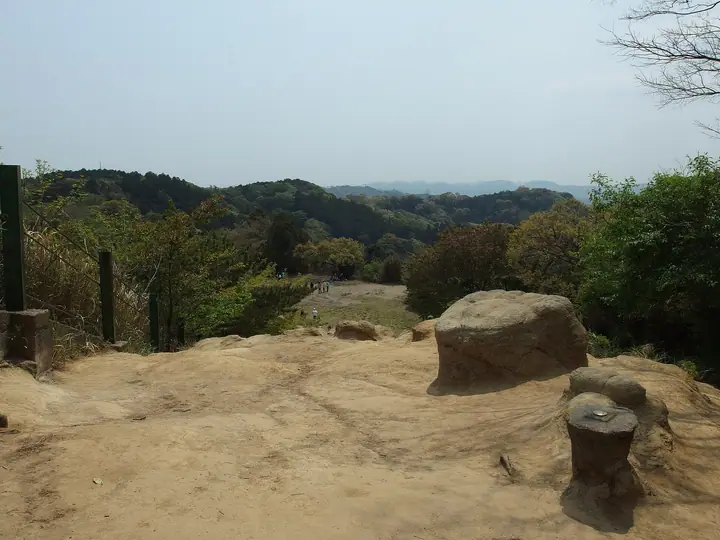
Mount Ōhira (Ōhirayama) is the high point of the 'Kamakura Alps'—the Tennen Hiking Course that traces the wooded ridge north-east of central Kamakura—and stands as the highest spot inside Kamakura City. The roughly 5 km traverse from Kenchō-ji and Hansōbō in north Kamakura over Jūō-iwa, Shōjōken and Ōhirayama on to Tennen (Rokkoku-tōge) and Zuisen-ji is one of the Kantō region's classic low-mountain pilgrimage walks, listed on the Kamakura City Tourism Association's official model courses.
Mount Ōhira at a glance
- Weather: The most settled day in the next 7 days is Fri, November 6: clear, gusts up to 5 m/s.
- Route: The shortest is Kamakura Alps Traverse from Konandai via Omaruyama and Tenen to Kita-Kamakura: about 4 h 5 min, 11.4 km, about 380 m of climbing.
Mount Ōhira weather (hourly, 14 days)
Sunrise today 06:04, sunset 16:46
| Tue, 11/3 | Wed, 11/4 | Thu, 11/5 | Fri, 11/6 | Sat, 11/7 | Sun, 11/8 | Mon, 11/9 | Tue, 11/10 | Wed, 11/11 | Thu, 11/12 | Fri, 11/13 | Sat, 11/14 | Sun, 11/15 | Mon, 11/16 | Tue, 11/17 | |||||||||||||||||||||||||||||||||||||||||||||||||||||||||||||||||||||||
|---|---|---|---|---|---|---|---|---|---|---|---|---|---|---|---|---|---|---|---|---|---|---|---|---|---|---|---|---|---|---|---|---|---|---|---|---|---|---|---|---|---|---|---|---|---|---|---|---|---|---|---|---|---|---|---|---|---|---|---|---|---|---|---|---|---|---|---|---|---|---|---|---|---|---|---|---|---|---|---|---|---|---|---|---|---|
| Japan time | 15 | 17 | 19 | 21 | 23 | 1 | 3 | 5 | 7 | 9 | 11 | 13 | 15 | 18 | 21 | 0 | 3 | 6 | 9 | 12 | 15 | 18 | 21 | 0 | 3 | 6 | 9 | 12 | 15 | 18 | 21 | 0 | 3 | 6 | 9 | 12 | 15 | 18 | 21 | 0 | 3 | 6 | 9 | 12 | 15 | 18 | 21 | 0 | 3 | 6 | 9 | 15 | 21 | 3 | 9 | 15 | 21 | 3 | 9 | 15 | 21 | 3 | 9 | 15 | 21 | 3 | 9 | 15 | 21 | 3 | 9 | 15 | 21 | 3 | 9 | 15 | 21 | 3 | 9 | 15 | 21 | 3 | 9 | 15 | |
  |   | | | | | |   |   |   | | | | | | | | | | |   |   | |   |   | |   |  | |  | | | | | | | | | | | | | | | | | | | | | | | | | |   | | | | |   | | | | |  | | | | | | | | | | | | | | | | | | | ||
| Temperature | °C | 18° | 17° | 16° | 15° | 14° | 13° | 13° | 12° | 12° | 12° | 13° | 14° | 14° | 13° | 11° | 11° | 11° | 12° | 14° | 19° | 17° | 16° | 15° | 14° | 13° | 13° | 16° | 20° | 21° | 17° | 16° | 15° | 14° | 12° | 14° | 16° | 17° | 14° | 11° | 10° | 9° | 9° | 11° | 13° | 14° | 13° | 13° | 12° | 10° | 10° | 10° | 13° | 11° | 10° | 10° | 12° | 9° | 8° | 12° | 15° | 10° | 8° | 10° | 14° | 11° | 9° | 12° | 14° | 10° | 8° | 10° | 13° | 11° | 8° | 10° | 17° | 16° | 16° | 15° | 21° | 13° | 11° | 10° | 12° |
| Precipitation | mm | 0.4 | 0.5 | 0.4 | 0.6 | 0.1 | 0.4 | 3.9 | 3.9 | 7 | 12 | 7 | 1.2 | 3.3 | 0.2 | 0.2 | 0.2 | 0.3 | 0.3 | 5 | 20 | 1.1 | |||||||||||||||||||||||||||||||||||||||||||||||||||||||||||||||
| New snow | cm | ||||||||||||||||||||||||||||||||||||||||||||||||||||||||||||||||||||||||||||||||||||
| Snow depth | cm | 0 | 0 | 0 | 0 | 0 | 0 | 0 | 0 | 0 | 0 | 0 | 0 | 0 | 0 | 0 | 0 | 0 | 0 | 0 | 0 | 0 | 0 | 0 | 0 | 0 | 0 | 0 | 0 | 0 | 0 | 0 | 0 | 0 | 0 | 0 | 0 | 0 | 0 | 0 | 0 | 0 | 0 | 0 | 0 | 0 | 0 | 0 | 0 | 0 | 0 | 0 | 0 | 0 | 0 | 0 | 0 | 0 | 0 | 0 | 0 | 0 | 0 | 0 | 0 | 0 | 0 | 0 | 0 | 0 | 0 | 0 | 0 | 0 | 0 | 0 | 0 | 0 | 0 | 0 | 0 | 0 | 0 | 0 | 0 |
| Wind | m/s | 2 | 1 | 1 | 1 | 3 | 4 | 4 | 4 | 4 | 4 | 4 | 4 | 4 | 5 | 5 | 6 | 6 | 6 | 6 | 5 | 2 | 1 | 2 | 2 | 1 | 1 | 1 | 1 | 1 | 0 | 2 | 4 | 4 | 3 | 4 | 3 | 2 | 3 | 4 | 4 | 4 | 4 | 4 | 3 | 2 | 2 | 2 | 2 | 4 | 4 | 4 | 4 | 4 | 4 | 4 | 3 | 2 | 2 | 1 | 6 | 5 | 4 | 2 | 2 | 2 | 1 | 1 | 4 | 4 | 3 | 2 | 1 | 1 | 2 | 1 | 5 | 5 | 2 | 1 | 2 | 7 | 4 | 3 | 3 |
| Wind gusts | m/s | 7 | 6 | 3 | 3 | 6 | 8 | 8 | 9 | 9 | 9 | 9 | 9 | 10 | 11 | 11 | 13 | 14 | 13 | 14 | 14 | 11 | 4 | 4 | 4 | 3 | 2 | 4 | 4 | 5 | 4 | 4 | 8 | 8 | 8 | 9 | 9 | 7 | 7 | 9 | 9 | 8 | 8 | 9 | 9 | 7 | 5 | 5 | 5 | 8 | 9 | 9 | 11 | 10 | 10 | 10 | 11 | 8 | 5 | 11 | 16 | 14 | 10 | 7 | 5 | 5 | 7 | 5 | 11 | 12 | 9 | 7 | 7 | 3 | 5 | 5 | 11 | 11 | 18 | 6 | 7 | 16 | 14 | 9 | 9 |
| Wind dir. | ↓ | ↓ | ↓ | ↓ | ↓ | ↓ | ↓ | ↓ | ↓ | ↓ | ↓ | ↓ | ↓ | ↓ | ↓ | ↓ | ↓ | ↓ | ↓ | ↓ | ↓ | ↓ | ↓ | ↓ | ↓ | ↓ | ↓ | ↓ | ↓ | ↓ | ↓ | ↓ | ↓ | ↓ | ↓ | ↓ | ↓ | ↓ | ↓ | ↓ | ↓ | ↓ | ↓ | ↓ | ↓ | ↓ | ↓ | ↓ | ↓ | ↓ | ↓ | ↓ | ↓ | ↓ | ↓ | ↓ | ↓ | ↓ | ↓ | ↓ | ↓ | ↓ | ↓ | ↓ | ↓ | ↓ | ↓ | ↓ | ↓ | ↓ | ↓ | ↓ | ↓ | ↓ | ↓ | ↓ | ↓ | ↓ | ↓ | ↓ | ↓ | ↓ | ↓ | ↓ | |
Mount Ōhira hiking routes
Hiking times are estimates calculated from the terrain.
Huts, campsites and lodging near Mount Ōhira
Lodging
- 上郷・森の家
- Casa Kamakura
- ホテルあじさい
- GEN Hotel Kamakura
- 鶴ヶ岡会館
Lists that include Mount Ōhira
Mount Ōhira facts
- Elevation
- 121 m
- Location
- Kamakura, Kanagawa
35.337534, 139.572340 - Website
- cms.trip-kamakura.com
- Trail Map
- www.trip-kamakura.com (PDF)
- Wikipedia
- ja.wikipedia.org