
Mount Nishi-Kumaneshiri
西クマネシリ岳
Ashoro, Hokkaido / Kamishihoro, Hokkaido · Elevation 1,635 m
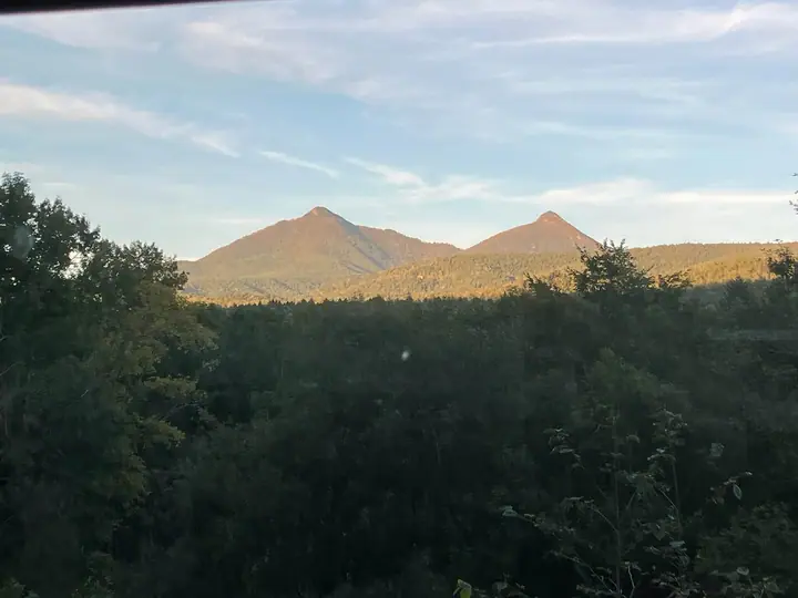
Mount Nishi-Kumaneshiri is a 1,635-meter peak in the Kumaneshiri massif of the East Daisetsu region of Hokkaido, straddling the towns of Kamishihoro and Ashoro. Its name derives from an Ainu term meaning "a mountain like a clothesline," and together with adjacent Mount Piribetsu it is locally nicknamed "Oppai-yama" for the twin-summit profile resembling a pair of breasts. The peak figures in Ainu cosmology as a site of divine land-making and is counted among the 100 famous mountains of Hokkaido.
Mount Nishi-Kumaneshiri at a glance
- Weather: The most settled day in the next 7 days is Mon, November 9: clear, gusts up to 7 m/s. Wed, Nov 4, Sat, Nov 7, Sun, Nov 8: strong wind (gusts up to 25 m/s).
Mount Nishi-Kumaneshiri weather (hourly, 14 days)
Sunrise today 06:04, sunset 16:17
| Tue, 11/3 | Wed, 11/4 | Thu, 11/5 | Fri, 11/6 | Sat, 11/7 | Sun, 11/8 | Mon, 11/9 | Tue, 11/10 | Wed, 11/11 | Thu, 11/12 | Fri, 11/13 | Sat, 11/14 | Sun, 11/15 | Mon, 11/16 | Tue, 11/17 | |||||||||||||||||||||||||||||||||||||||||||||||||||||||||||||||||||||||
|---|---|---|---|---|---|---|---|---|---|---|---|---|---|---|---|---|---|---|---|---|---|---|---|---|---|---|---|---|---|---|---|---|---|---|---|---|---|---|---|---|---|---|---|---|---|---|---|---|---|---|---|---|---|---|---|---|---|---|---|---|---|---|---|---|---|---|---|---|---|---|---|---|---|---|---|---|---|---|---|---|---|---|---|---|---|
| Japan time | 15 | 17 | 19 | 21 | 23 | 1 | 3 | 5 | 7 | 9 | 11 | 13 | 15 | 18 | 21 | 0 | 3 | 6 | 9 | 12 | 15 | 18 | 21 | 0 | 3 | 6 | 9 | 12 | 15 | 18 | 21 | 0 | 3 | 6 | 9 | 12 | 15 | 18 | 21 | 0 | 3 | 6 | 9 | 12 | 15 | 18 | 21 | 0 | 3 | 6 | 9 | 15 | 21 | 3 | 9 | 15 | 21 | 3 | 9 | 15 | 21 | 3 | 9 | 15 | 21 | 3 | 9 | 15 | 21 | 3 | 9 | 15 | 21 | 3 | 9 | 15 | 21 | 3 | 9 | 15 | 21 | 3 | 9 | 15 | |
  |   |   | | |   | |   |   | |   |   |  |  | | | | | | | |   |   | | | |   | |   | |   | | | |   | | | | | | | | | | | | | | | | | | | | | | | | | | | | | | | | | | |  | | | | |   | | | | | | | | | | ||
| Temperature | °C | -4° | -7° | -7° | -8° | -7° | -8° | -5° | -5° | -4° | -4° | -3° | -2° | -2° | -8° | -9° | -10° | -10° | -9° | 1° | 4° | 2° | -3° | -2° | -2° | -2° | -1° | 1° | 2° | 3° | 1° | -3° | -5° | -9° | -9° | -8° | -8° | -9° | -9° | -9° | -9° | -10° | -9° | -8° | -7° | -7° | -8° | -8° | -10° | -10° | -11° | -7° | -7° | -12° | -13° | -7° | -5° | -10° | -10° | -7° | -5° | -14° | -16° | -6° | -5° | -10° | -10° | -9° | -9° | -10° | -16° | -6° | -4° | -12° | -13° | 0° | -1° | -2° | -3° | -2° | -4° | -8° | -9° | -7° | -4° |
| Precipitation | mm | 1.1 | 0.3 | 0.2 | 0.1 | 0.1 | 0.7 | 1.9 | 2.4 | 3.2 | 1.4 | 0.2 | 0.2 | 0.1 | 0.1 | 0.2 | 0.7 | 0.6 | 0.2 | 0.3 | 0.3 | 0.6 | 0.8 | 1.3 | 1.3 | 0.9 | 0.3 | 0.8 | 1.5 | 0.2 | 0.3 | 0.2 | 0.2 | 0.5 | 0.8 | 0.3 | 3.2 | 0.1 | |||||||||||||||||||||||||||||||||||||||||||||||
| New snow | cm | <.1 | <.1 | 1.1 | 0.3 | 0.2 | 0.1 | 0.1 | <.1 | <.1 | 0.3 | 0.7 | 0.6 | 0.2 | 0.3 | 0.3 | 0.6 | 0.8 | 1.3 | 1.3 | 0.9 | 0.3 | <.1 | 0.8 | 1.5 | 0.2 | <.1 | <.1 | 0.3 | 0.2 | 0.2 | 2.9 | 0.1 | <.1 | <.1 | ||||||||||||||||||||||||||||||||||||||||||||||||||
| Snow depth | cm | <1 | <1 | <1 | <1 | <1 | <1 | <1 | <1 | 2 | 2 | 2 | 2 | 2 | 2 | <1 | <1 | <1 | <1 | <1 | <1 | <1 | <1 | <1 | <1 | <1 | <1 | <1 | 0 | 0 | 0 | 0 | 0 | 0 | 0 | 0 | <1 | <1 | 2 | 2 | 2 | 2 | 3 | 3 | 4 | 4 | 4 | 4 | 4 | 4 | 4 | 4 | 4 | 3 | 3 | 3 | 3 | 3 | 4 | 6 | 5 | 5 | 5 | 5 | 4 | 4 | 4 | 5 | 5 | 5 | 4 | 4 | 4 | 4 | 4 | 4 | 3 | 3 | 2 | 2 | 4 | 4 | 4 | 4 | 4 |
| Wind | m/s | 4 | 2 | 2 | 1 | 2 | 2 | 4 | 4 | 5 | 5 | 4 | 2 | 2 | 2 | 2 | 2 | 2 | 2 | 2 | 4 | 2 | 1 | 1 | 1 | 1 | 1 | 2 | 2 | 4 | 5 | 4 | 5 | 6 | 6 | 7 | 9 | 5 | 1 | 1 | 6 | 5 | 7 | 7 | 8 | 7 | 8 | 6 | 1 | 1 | 1 | 1 | 2 | 1 | 1 | 0 | 2 | 1 | 0 | 0 | 1 | 1 | 1 | 1 | 2 | 1 | 0 | 2 | 2 | 5 | 2 | 1 | 1 | 1 | 1 | 1 | 2 | 3 | 2 | 1 | 3 | 3 | 1 | 1 | 1 |
| Wind gusts | m/s | 13 | 10 | 7 | 6 | 7 | 8 | 11 | 11 | 16 | 14 | 13 | 11 | 7 | 5 | 7 | 7 | 7 | 9 | 8 | 11 | 11 | 6 | 4 | 4 | 3 | 5 | 6 | 8 | 11 | 14 | 13 | 15 | 18 | 18 | 19 | 23 | 25 | 16 | 8 | 19 | 18 | 22 | 20 | 23 | 22 | 23 | 22 | 17 | 6 | 4 | 5 | 7 | 6 | 4 | 3 | 6 | 7 | 2 | 3 | 5 | 4 | 3 | 4 | 8 | 6 | 4 | 6 | 11 | 16 | 14 | 7 | 4 | 4 | 4 | 7 | 9 | 9 | 9 | 7 | 8 | 10 | 8 | 4 | 4 |
| Wind dir. | ↓ | ↓ | ↓ | ↓ | ↓ | ↓ | ↓ | ↓ | ↓ | ↓ | ↓ | ↓ | ↓ | ↓ | ↓ | ↓ | ↓ | ↓ | ↓ | ↓ | ↓ | ↓ | ↓ | ↓ | ↓ | ↓ | ↓ | ↓ | ↓ | ↓ | ↓ | ↓ | ↓ | ↓ | ↓ | ↓ | ↓ | ↓ | ↓ | ↓ | ↓ | ↓ | ↓ | ↓ | ↓ | ↓ | ↓ | ↓ | ↓ | ↓ | ↓ | ↓ | ↓ | ↓ | ↓ | ↓ | ↓ | ↓ | ↓ | ↓ | ↓ | ↓ | ↓ | ↓ | ↓ | ↓ | ↓ | ↓ | ↓ | ↓ | ↓ | ↓ | ↓ | ↓ | ↓ | ↓ | ↓ | ↓ | ↓ | ↓ | ↓ | ↓ | ↓ | ↓ | |
Lists that include Mount Nishi-Kumaneshiri
Hokkaido 100 Famous Mountains · Elevations of 1003 Mountains of Japan · 1000 Mountains of Japan
Mount Nishi-Kumaneshiri facts
- Also known as
- オッパイ山
- Elevation
- 1,635 m
- Location
- Ashoro, Hokkaido / Kamishihoro, Hokkaido
43.519116, 143.233266 - Website
- www.kamishihoro.jp
- Access Information
- www.rinya.maff.go.jp
- Wikipedia
- ja.wikipedia.org