
Mount Katsuu
嘉津宇岳
Nago, Okinawa · Elevation 452 m
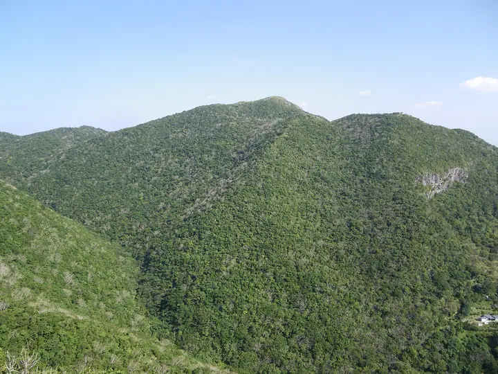
A 452-meter peak in Katsuyama, Nago City, on the Motobu Peninsula of northern Okinawa Main Island. The mountain is the sixth highest in Okinawa Prefecture and the third highest on the main island; its symmetrical conical form is the product of conical karst topography over Permian limestone. Long renowned alongside Mount Onna as a famous scenic peak—it appears in the Omoro Soshi anthology—it was thought to be the highest mountain on the island until Japan's Land Survey Department remeasured it in 1916. Together with the neighboring Wa-dake and Yae-dake, the slopes are protected as the Katsuudake-Wadake-Yaedake Nature Conservation Area, a Prefectural Natural Monument harboring rare plants. From a trailhead at about 270 meters, the summit is reached in roughly forty minutes, with a panorama over Nago City, the East China Sea, and the Yanbaru highlands.
Mount Katsuu at a glance
- Weather: The most settled day in the next 7 days is Thu, November 5: clear, gusts up to 7 m/s. Sat, Nov 7: strong wind (gusts up to 16 m/s).
- Route: The shortest is Mount Katsuu Out-and-Back: about 1 h, 1.4 km, about 170 m of climbing.
Mount Katsuu weather (hourly, 14 days)
Sunrise today 06:39, sunset 17:45
| Tue, 11/3 | Wed, 11/4 | Thu, 11/5 | Fri, 11/6 | Sat, 11/7 | Sun, 11/8 | Mon, 11/9 | Tue, 11/10 | Wed, 11/11 | Thu, 11/12 | Fri, 11/13 | Sat, 11/14 | Sun, 11/15 | Mon, 11/16 | Tue, 11/17 | |||||||||||||||||||||||||||||||||||||||||||||||||||||||||||||||||||||||
|---|---|---|---|---|---|---|---|---|---|---|---|---|---|---|---|---|---|---|---|---|---|---|---|---|---|---|---|---|---|---|---|---|---|---|---|---|---|---|---|---|---|---|---|---|---|---|---|---|---|---|---|---|---|---|---|---|---|---|---|---|---|---|---|---|---|---|---|---|---|---|---|---|---|---|---|---|---|---|---|---|---|---|---|---|---|
| Japan time | 15 | 17 | 19 | 21 | 23 | 1 | 3 | 5 | 7 | 9 | 11 | 13 | 15 | 18 | 21 | 0 | 3 | 6 | 9 | 12 | 15 | 18 | 21 | 0 | 3 | 6 | 9 | 12 | 15 | 18 | 21 | 0 | 3 | 6 | 9 | 12 | 15 | 18 | 21 | 0 | 3 | 6 | 9 | 12 | 15 | 18 | 21 | 0 | 3 | 6 | 9 | 15 | 21 | 3 | 9 | 15 | 21 | 3 | 9 | 15 | 21 | 3 | 9 | 15 | 21 | 3 | 9 | 15 | 21 | 3 | 9 | 15 | 21 | 3 | 9 | 15 | 21 | 3 | 9 | 15 | 21 | 3 | 9 | 15 | |
  | |  |   | | | | |  | | |   | |  | | | | | | | |   |   |   | |   | | | |   | | | | | | | | | | | | | | | | | |   | | | | | | |   |   | | | | | | | | |  | | | | | | |   | | | | | | |   | | | | | | ||
| Temperature | °C | 21° | 21° | 21° | 21° | 21° | 21° | 21° | 21° | 21° | 23° | 24° | 24° | 23° | 21° | 20° | 20° | 20° | 19° | 23° | 24° | 24° | 22° | 21° | 21° | 21° | 21° | 22° | 23° | 23° | 21° | 21° | 21° | 20° | 20° | 20° | 21° | 21° | 20° | 20° | 21° | 20° | 19° | 22° | 23° | 22° | 21° | 20° | 20° | 20° | 20° | 22° | 23° | 20° | 19° | 19° | 19° | 19° | 18° | 19° | 19° | 18° | 17° | 19° | 21° | 19° | 18° | 20° | 21° | 19° | 19° | 21° | 23° | 21° | 20° | 20° | 21° | 21° | 20° | 21° | 20° | 20° | 20° | 22° | 21° |
| Precipitation | mm | 0.2 | 1.3 | 0.7 | 0.5 | 0.4 | 0.3 | 0.3 | 5 | 1.4 | 0.4 | 0.6 | 6 | 11 | 17 | 0.5 | 0.2 | 1.0 | 0.4 | ||||||||||||||||||||||||||||||||||||||||||||||||||||||||||||||||||
| New snow | cm | ||||||||||||||||||||||||||||||||||||||||||||||||||||||||||||||||||||||||||||||||||||
| Snow depth | cm | 0 | 0 | 0 | 0 | 0 | 0 | 0 | 0 | 0 | 0 | 0 | 0 | 0 | 0 | 0 | 0 | 0 | 0 | 0 | 0 | 0 | 0 | 0 | 0 | 0 | 0 | 0 | 0 | 0 | 0 | 0 | 0 | 0 | 0 | 0 | 0 | 0 | 0 | 0 | 0 | 0 | 0 | 0 | 0 | 0 | 0 | 0 | 0 | 0 | 0 | 0 | 0 | 0 | 0 | 0 | 0 | 0 | 0 | 0 | 0 | 0 | 0 | 0 | 0 | 0 | 0 | 0 | 0 | 0 | 0 | 0 | 0 | 0 | 0 | 0 | 0 | 0 | 0 | 0 | 0 | 0 | 0 | 0 | 0 |
| Wind | m/s | 7 | 7 | 6 | 4 | 4 | 4 | 4 | 4 | 4 | 5 | 5 | 5 | 4 | 3 | 2 | 0 | 0 | 1 | 3 | 3 | 3 | 4 | 4 | 4 | 5 | 6 | 5 | 5 | 5 | 6 | 8 | 7 | 9 | 9 | 9 | 9 | 8 | 7 | 6 | 5 | 5 | 4 | 5 | 4 | 3 | 3 | 3 | 2 | 2 | 3 | 4 | 4 | 2 | 1 | 10 | 10 | 9 | 8 | 7 | 6 | 4 | 3 | 4 | 3 | 3 | 4 | 5 | 4 | 3 | 2 | 3 | 5 | 5 | 5 | 4 | 7 | 4 | 3 | 5 | 5 | 3 | 3 | 3 | 4 |
| Wind gusts | m/s | 13 | 13 | 11 | 10 | 8 | 8 | 8 | 7 | 7 | 9 | 9 | 9 | 9 | 8 | 7 | 4 | 1 | 1 | 5 | 7 | 7 | 7 | 7 | 7 | 9 | 10 | 10 | 11 | 11 | 11 | 14 | 13 | 15 | 15 | 16 | 16 | 16 | 16 | 13 | 11 | 9 | 9 | 9 | 11 | 8 | 7 | 6 | 5 | 4 | 5 | 8 | 10 | 9 | 4 | 17 | 19 | 19 | 16 | 14 | 14 | 12 | 7 | 8 | 8 | 7 | 6 | 10 | 10 | 10 | 6 | 6 | 10 | 9 | 11 | 10 | 13 | 13 | 6 | 9 | 10 | 9 | 6 | 6 | 9 |
| Wind dir. | ↓ | ↓ | ↓ | ↓ | ↓ | ↓ | ↓ | ↓ | ↓ | ↓ | ↓ | ↓ | ↓ | ↓ | ↓ | ↓ | ↓ | ↓ | ↓ | ↓ | ↓ | ↓ | ↓ | ↓ | ↓ | ↓ | ↓ | ↓ | ↓ | ↓ | ↓ | ↓ | ↓ | ↓ | ↓ | ↓ | ↓ | ↓ | ↓ | ↓ | ↓ | ↓ | ↓ | ↓ | ↓ | ↓ | ↓ | ↓ | ↓ | ↓ | ↓ | ↓ | ↓ | ↓ | ↓ | ↓ | ↓ | ↓ | ↓ | ↓ | ↓ | ↓ | ↓ | ↓ | ↓ | ↓ | ↓ | ↓ | ↓ | ↓ | ↓ | ↓ | ↓ | ↓ | ↓ | ↓ | ↓ | ↓ | ↓ | ↓ | ↓ | ↓ | ↓ | ↓ | |
Mount Katsuu hiking routes
- Mount Katsuu Out-and-Back 1.4 km · Ascent 170 m parking
- Mount Katsū and Furushi Loop 4.9 km · Ascent 396 m parking
- Katsuyama Traverse from Mount Sankaku via Mount Awa and Mount Furushi to Mount Katsuu 5.0 km · Ascent 664 m parking
Hiking times are estimates calculated from the terrain.
Huts, campsites and lodging near Mount Katsuu
Lodging
- ホテルリゾネックス名護
- Condominium Hotel Nago Resort LIETA. NAKAYAMA
- PANORAMA Ocean View Cottage
- 美ら海オンザビーチMOTOBU
- コテージ幸
Mount Katsuu facts
- Elevation
- 452 m
- Location
- Nago, Okinawa
26.631165, 127.934879 - Website
- nagomun.or.jp
- Wikipedia
- ja.wikipedia.org