
Mount Katsuu
嘉津宇岳
นาโงะ, โอกินาวะ · ความสูง 452 ม.
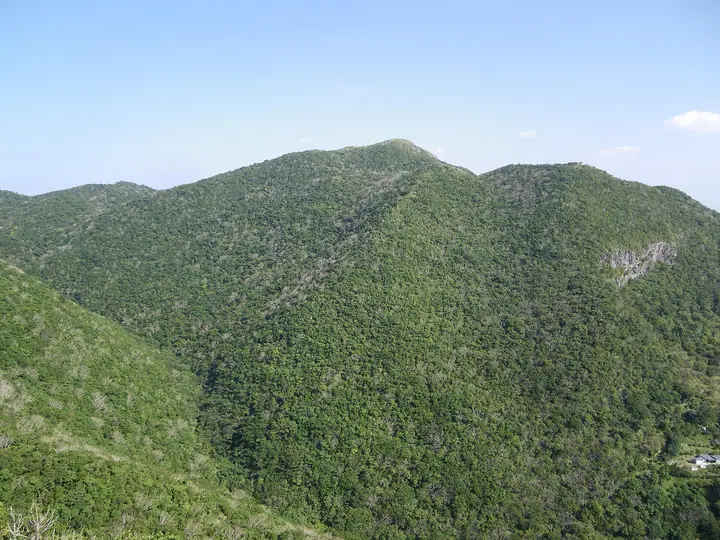
A 452-meter peak in Katsuyama, Nago City, on the Motobu Peninsula of northern Okinawa Main Island. The mountain is the sixth highest in Okinawa Prefecture and the third highest on the main island; its symmetrical conical form is the product of conical karst topography over Permian limestone. Long renowned alongside Mount Onna as a famous scenic peak—it appears in the Omoro Soshi anthology—it was thought to be the highest mountain on the island until Japan's Land Survey Department remeasured it in 1916. Together with the neighboring Wa-dake and Yae-dake, the slopes are protected as the Katsuudake-Wadake-Yaedake Nature Conservation Area, a Prefectural Natural Monument harboring rare plants. From a trailhead at about 270 meters, the summit is reached in roughly forty minutes, with a panorama over Nago City, the East China Sea, and the Yanbaru highlands.
สรุป Mount Katsuu
- อากาศ: วันที่อากาศคงที่ที่สุดใน 7 วันข้างหน้าคือ พฤหัส 5 พฤศจิกายน: ท้องฟ้าแจ่มใส ลมกระโชกสูงสุด 9 ม./วินาที เสาร์ 7 พ.ย. ลมแรง (ลมกระโชกสูงสุด 17 ม./วินาที)
- เส้นทาง: เส้นทางที่สั้นที่สุดคือ Mount Katsuu Out-and-Back: ประมาณ 1 ชม. 1.4 km ขึ้นประมาณ 170 m
อากาศ Mount Katsuu (รายชั่วโมง 2 สัปดาห์)
วันนี้พระอาทิตย์ขึ้น 06:39 ตก 17:45
| อังคาร 3/11 | พุธ 4/11 | พฤหัส 5/11 | ศุกร์ 6/11 | เสาร์ 7/11 | อาทิตย์ 8/11 | จันทร์ 9/11 | อังคาร 10/11 | พุธ 11/11 | พฤหัส 12/11 | ศุกร์ 13/11 | เสาร์ 14/11 | อาทิตย์ 15/11 | จันทร์ 16/11 | อังคาร 17/11 | |||||||||||||||||||||||||||||||||||||||||||||||||||||||||||||||||||||||
|---|---|---|---|---|---|---|---|---|---|---|---|---|---|---|---|---|---|---|---|---|---|---|---|---|---|---|---|---|---|---|---|---|---|---|---|---|---|---|---|---|---|---|---|---|---|---|---|---|---|---|---|---|---|---|---|---|---|---|---|---|---|---|---|---|---|---|---|---|---|---|---|---|---|---|---|---|---|---|---|---|---|---|---|---|---|
| เวลาญี่ปุ่น | 21 | 23 | 1 | 3 | 5 | 7 | 9 | 11 | 13 | 15 | 17 | 19 | 21 | 0 | 3 | 6 | 9 | 12 | 15 | 18 | 21 | 0 | 3 | 6 | 9 | 12 | 15 | 18 | 21 | 0 | 3 | 6 | 9 | 12 | 15 | 18 | 21 | 0 | 3 | 6 | 9 | 12 | 15 | 18 | 21 | 0 | 3 | 6 | 9 | 12 | 15 | 21 | 3 | 9 | 15 | 21 | 3 | 9 | 15 | 21 | 3 | 9 | 15 | 21 | 3 | 9 | 15 | 21 | 3 | 9 | 15 | 21 | 3 | 9 | 15 | 21 | 3 | 9 | 15 | 21 | 3 | 9 | 15 | 21 | |
  | | |  | |  | |   |   | | |  | | | | | | | |   | | | | | | | |   | | | | | | | | | | | | | | | | | |   | |   |   | | | |   |   |   | | | | | | | | |  | | | | | | | | | | | | | |   | | | | | |   | ||
| อุณหภูมิ | °C | 21° | 21° | 21° | 21° | 20° | 20° | 23° | 24° | 24° | 23° | 22° | 21° | 20° | 20° | 20° | 20° | 23° | 24° | 24° | 22° | 22° | 21° | 21° | 21° | 22° | 23° | 22° | 21° | 21° | 21° | 20° | 20° | 21° | 21° | 21° | 20° | 21° | 21° | 20° | 19° | 22° | 23° | 23° | 21° | 20° | 20° | 20° | 20° | 23° | 23° | 23° | 20° | 19° | 19° | 19° | 19° | 18° | 19° | 19° | 18° | 17° | 19° | 21° | 19° | 18° | 20° | 21° | 19° | 19° | 21° | 23° | 21° | 20° | 20° | 21° | 21° | 20° | 21° | 20° | 20° | 20° | 22° | 21° | 20° |
| ฝนและหิมะ | mm | 0.2 | 0.1 | 0.1 | 0.2 | 0.2 | 0.3 | 0.3 | 5 | 1.4 | 0.4 | 0.6 | 6 | 11 | 17 | 0.5 | 0.2 | 1.0 | 0.4 | ||||||||||||||||||||||||||||||||||||||||||||||||||||||||||||||||||
| หิมะตก | cm | ||||||||||||||||||||||||||||||||||||||||||||||||||||||||||||||||||||||||||||||||||||
| หิมะสะสม | cm | 0 | 0 | 0 | 0 | 0 | 0 | 0 | 0 | 0 | 0 | 0 | 0 | 0 | 0 | 0 | 0 | 0 | 0 | 0 | 0 | 0 | 0 | 0 | 0 | 0 | 0 | 0 | 0 | 0 | 0 | 0 | 0 | 0 | 0 | 0 | 0 | 0 | 0 | 0 | 0 | 0 | 0 | 0 | 0 | 0 | 0 | 0 | 0 | 0 | 0 | 0 | 0 | 0 | 0 | 0 | 0 | 0 | 0 | 0 | 0 | 0 | 0 | 0 | 0 | 0 | 0 | 0 | 0 | 0 | 0 | 0 | 0 | 0 | 0 | 0 | 0 | 0 | 0 | 0 | 0 | 0 | 0 | 0 | 0 |
| ลม | m/s | 4 | 3 | 5 | 4 | 4 | 4 | 5 | 4 | 4 | 4 | 3 | 3 | 3 | 1 | 0 | 0 | 3 | 3 | 5 | 5 | 5 | 5 | 5 | 5 | 5 | 5 | 6 | 7 | 7 | 6 | 7 | 8 | 9 | 9 | 8 | 8 | 6 | 5 | 6 | 4 | 5 | 4 | 4 | 3 | 3 | 2 | 2 | 3 | 4 | 4 | 5 | 2 | 1 | 10 | 10 | 9 | 8 | 7 | 6 | 4 | 3 | 4 | 3 | 3 | 4 | 5 | 4 | 3 | 2 | 3 | 5 | 5 | 5 | 4 | 7 | 4 | 3 | 5 | 5 | 3 | 3 | 3 | 4 | 3 |
| ลมกระโชก | m/s | 10 | 7 | 9 | 8 | 7 | 7 | 9 | 9 | 9 | 9 | 9 | 5 | 5 | 5 | 2 | 1 | 5 | 7 | 9 | 9 | 9 | 9 | 10 | 9 | 10 | 11 | 12 | 12 | 12 | 13 | 12 | 14 | 17 | 17 | 16 | 15 | 13 | 11 | 10 | 10 | 10 | 11 | 9 | 8 | 6 | 5 | 3 | 5 | 8 | 9 | 9 | 9 | 4 | 17 | 19 | 19 | 16 | 14 | 14 | 12 | 7 | 8 | 8 | 7 | 6 | 10 | 10 | 10 | 6 | 6 | 10 | 9 | 11 | 10 | 13 | 13 | 6 | 9 | 10 | 9 | 6 | 6 | 9 | 8 |
| ทิศทางลม | ↓ | ↓ | ↓ | ↓ | ↓ | ↓ | ↓ | ↓ | ↓ | ↓ | ↓ | ↓ | ↓ | ↓ | ↓ | ↓ | ↓ | ↓ | ↓ | ↓ | ↓ | ↓ | ↓ | ↓ | ↓ | ↓ | ↓ | ↓ | ↓ | ↓ | ↓ | ↓ | ↓ | ↓ | ↓ | ↓ | ↓ | ↓ | ↓ | ↓ | ↓ | ↓ | ↓ | ↓ | ↓ | ↓ | ↓ | ↓ | ↓ | ↓ | ↓ | ↓ | ↓ | ↓ | ↓ | ↓ | ↓ | ↓ | ↓ | ↓ | ↓ | ↓ | ↓ | ↓ | ↓ | ↓ | ↓ | ↓ | ↓ | ↓ | ↓ | ↓ | ↓ | ↓ | ↓ | ↓ | ↓ | ↓ | ↓ | ↓ | ↓ | ↓ | ↓ | ↓ | |
เส้นทางเดินป่า Mount Katsuu
- Mount Katsuu Out-and-Back 1.4 km · ความสูงสะสมขาขึ้น 170 m มีที่จอดรถ
- Mount Katsū and Furushi Loop 4.9 km · ความสูงสะสมขาขึ้น 396 m มีที่จอดรถ
- Katsuyama Traverse from Mount Sankaku via Mount Awa and Mount Furushi to Mount Katsuu 5.0 km · ความสูงสะสมขาขึ้น 664 m มีที่จอดรถ
เวลาเดินเป็นค่าประมาณที่คำนวณจากภูมิประเทศ
กระท่อม ที่ตั้งแคมป์ และที่พักใกล้ Mount Katsuu
ที่พัก
- ホテルリゾネックス名護
- Condominium Hotel Nago Resort LIETA. NAKAYAMA
- PANORAMA Ocean View Cottage
- 美ら海オンザビーチMOTOBU
- コテージ幸
ข้อมูลพื้นฐาน Mount Katsuu
- ความสูง
- 452 ม.
- ที่ตั้ง
- นาโงะ, โอกินาวะ
26.631165, 127.934879 - เว็บไซต์
- nagomun.or.jp
- วิกิพีเดีย
- ja.wikipedia.org