
Mount Kamafuse
釜臥山
Mutsu, Aomori · Elevation 879 m
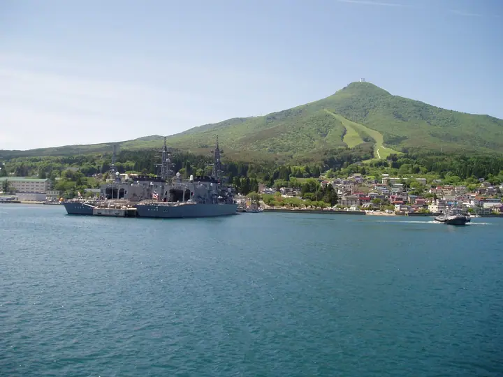
Mount Kamafuse is a 879-meter peak in central Shimokita Peninsula of Aomori Prefecture, the highest summit of the Osore mountain group and a pre-caldera volcano of Osorezan. Within Mutsu City, it has long been revered as a sacred mountain rising directly above the Osorezan temple grounds. An observation deck at 785 m offers night views of the Mutsu Bay shoreline that take the silhouette of a swallowtail butterfly, recognized as one of Japan's Night-View Heritage sites. The peak lies within Shimokita Peninsula Quasi-National Park.
Mount Kamafuse at a glance
- Weather: The most settled day in the next 7 days is Thu, November 5: cloudy, gusts up to 4 m/s. Sat, Nov 7, Sun, Nov 8: strong wind (gusts up to 21 m/s).
Mount Kamafuse weather (hourly, 14 days)
Sunrise today 06:08, sunset 16:30
| Tue, 11/3 | Wed, 11/4 | Thu, 11/5 | Fri, 11/6 | Sat, 11/7 | Sun, 11/8 | Mon, 11/9 | Tue, 11/10 | Wed, 11/11 | Thu, 11/12 | Fri, 11/13 | Sat, 11/14 | Sun, 11/15 | Mon, 11/16 | Tue, 11/17 | |||||||||||||||||||||||||||||||||||||||||||||||||||||||||||||||||||||||
|---|---|---|---|---|---|---|---|---|---|---|---|---|---|---|---|---|---|---|---|---|---|---|---|---|---|---|---|---|---|---|---|---|---|---|---|---|---|---|---|---|---|---|---|---|---|---|---|---|---|---|---|---|---|---|---|---|---|---|---|---|---|---|---|---|---|---|---|---|---|---|---|---|---|---|---|---|---|---|---|---|---|---|---|---|---|
| Japan time | 15 | 17 | 19 | 21 | 23 | 1 | 3 | 5 | 7 | 9 | 11 | 13 | 15 | 18 | 21 | 0 | 3 | 6 | 9 | 12 | 15 | 18 | 21 | 0 | 3 | 6 | 9 | 12 | 15 | 18 | 21 | 0 | 3 | 6 | 9 | 12 | 15 | 18 | 21 | 0 | 3 | 6 | 9 | 12 | 15 | 18 | 21 | 0 | 3 | 6 | 9 | 15 | 21 | 3 | 9 | 15 | 21 | 3 | 9 | 15 | 21 | 3 | 9 | 15 | 21 | 3 | 9 | 15 | 21 | 3 | 9 | 15 | 21 | 3 | 9 | 15 | 21 | 3 | 9 | 15 | 21 | 3 | 9 | 15 | |
 |  | | | |   |   |   | | | | | |  |   | |   | |   |   | |   | | | | |   |   | | | | | |   |   |   | | | | | |   | | | | | | | | | |   | | | | |   | |   |   | | | | | |  | | | | | | | | | | | | | | | |  | | | ||
| Temperature | °C | 4° | 2° | 2° | 2° | 2° | 4° | 3° | 4° | 4° | 5° | 6° | 6° | 5° | 2° | 2° | 3° | 3° | 4° | 7° | 8° | 8° | 8° | 8° | 8° | 8° | 8° | 9° | 10° | 8° | 6° | 2° | 0° | 0° | -2° | 0° | 0° | -1° | -1° | -1° | -1° | -2° | -1° | 0° | 1° | 0° | 0° | -1° | -1° | -1° | -2° | 0° | 0° | -2° | -2° | -1° | 0° | -1° | 0° | 0° | 1° | 0° | -2° | 3° | 2° | 0° | -3° | 0° | -1° | -4° | -4° | 0° | 3° | 0° | 1° | 5° | 7° | 5° | 4° | 5° | 1° | -2° | -3° | 1° | 2° |
| Precipitation | mm | 1.1 | 0.4 | 0.7 | 4.6 | 5 | 2.2 | 0.3 | 0.8 | 1.0 | 0.4 | 0.4 | 0.7 | 1.1 | 0.7 | 0.5 | 0.4 | 0.3 | 0.3 | 0.2 | 0.2 | 0.2 | 1.8 | 10 | 11 | 2.1 | 0.7 | 0.9 | 0.3 | 3.4 | 0.5 | 2.9 | 0.3 | ||||||||||||||||||||||||||||||||||||||||||||||||||||
| New snow | cm | 0.2 | 0.5 | 0.3 | 0.1 | <.1 | <.1 | <.1 | <.1 | <.1 | 0.2 | <.1 | 0.3 | ||||||||||||||||||||||||||||||||||||||||||||||||||||||||||||||||||||||||
| Snow depth | cm | 0 | 0 | 0 | 0 | 0 | 0 | 0 | 0 | 0 | 0 | 0 | 0 | 0 | 0 | 0 | 0 | 0 | 0 | 0 | 0 | 0 | 0 | 0 | 0 | 0 | 0 | 0 | 0 | 0 | 0 | 0 | 0 | 0 | 0 | <1 | <1 | 0 | <1 | 0 | 0 | 0 | 0 | 0 | 0 | 0 | 0 | 0 | 0 | 0 | 0 | 0 | 0 | 0 | 0 | 0 | 0 | 0 | 0 | <1 | 0 | 0 | 0 | 0 | 0 | 0 | 0 | 0 | 0 | 0 | 0 | 0 | 0 | 0 | 0 | 0 | 0 | 0 | 0 | 0 | 0 | 0 | 0 | 0 | 0 |
| Wind | m/s | 6 | 4 | 3 | 3 | 4 | 6 | 6 | 5 | 5 | 5 | 4 | 4 | 3 | 1 | 2 | 0 | 0 | 0 | 1 | 1 | 1 | 1 | 3 | 2 | 3 | 3 | 4 | 5 | 8 | 11 | 11 | 9 | 8 | 8 | 9 | 10 | 10 | 8 | 8 | 8 | 8 | 8 | 8 | 10 | 10 | 8 | 5 | 4 | 4 | 3 | 6 | 5 | 3 | 2 | 1 | 4 | 5 | 7 | 8 | 2 | 2 | 1 | 4 | 4 | 1 | 3 | 4 | 4 | 3 | 2 | 1 | 3 | 2 | 3 | 4 | 2 | 3 | 2 | 1 | 4 | 5 | 2 | 3 | 4 |
| Wind gusts | m/s | 12 | 11 | 7 | 7 | 8 | 11 | 12 | 12 | 10 | 11 | 10 | 8 | 8 | 6 | 4 | 4 | 2 | 3 | 4 | 4 | 3 | 3 | 8 | 7 | 5 | 5 | 8 | 12 | 15 | 20 | 21 | 21 | 18 | 17 | 17 | 20 | 20 | 19 | 16 | 16 | 15 | 15 | 16 | 19 | 21 | 20 | 15 | 10 | 9 | 9 | 11 | 12 | 11 | 6 | 5 | 9 | 11 | 14 | 15 | 14 | 5 | 6 | 8 | 13 | 9 | 7 | 9 | 10 | 9 | 6 | 5 | 7 | 7 | 6 | 7 | 7 | 5 | 5 | 4 | 9 | 10 | 10 | 6 | 10 |
| Wind dir. | ↓ | ↓ | ↓ | ↓ | ↓ | ↓ | ↓ | ↓ | ↓ | ↓ | ↓ | ↓ | ↓ | ↓ | ↓ | ↓ | ↓ | ↓ | ↓ | ↓ | ↓ | ↓ | ↓ | ↓ | ↓ | ↓ | ↓ | ↓ | ↓ | ↓ | ↓ | ↓ | ↓ | ↓ | ↓ | ↓ | ↓ | ↓ | ↓ | ↓ | ↓ | ↓ | ↓ | ↓ | ↓ | ↓ | ↓ | ↓ | ↓ | ↓ | ↓ | ↓ | ↓ | ↓ | ↓ | ↓ | ↓ | ↓ | ↓ | ↓ | ↓ | ↓ | ↓ | ↓ | ↓ | ↓ | ↓ | ↓ | ↓ | ↓ | ↓ | ↓ | ↓ | ↓ | ↓ | ↓ | ↓ | ↓ | ↓ | ↓ | ↓ | ↓ | ↓ | ↓ | |
Huts, campsites and lodging near Mount Kamafuse
Campsites
- 矢立温泉キャンプ場
Lodging
- フォルクローロ大湊
- 畑中旅館
Lists that include Mount Kamafuse
Illustrated Collection of Japan's Famous Mountains · 110 Mountains of Aomori · Elevations of 1003 Mountains of Japan · 1000 Mountains of Japan
Mount Kamafuse facts
- Elevation
- 879 m
- Location
- Mutsu, Aomori
41.278504, 141.120050 - National Park
- 下北半島国定公園
- Volcano
- Active volcano (恐山)
- Website
- shimokita-geopark.com
- Trail Map
- shimokita-geopark.com (PDF)
- Wikipedia
- ja.wikipedia.org