
Mount Kaimon
開聞岳
Ibusuki, Kagoshima · Elevation 924 m
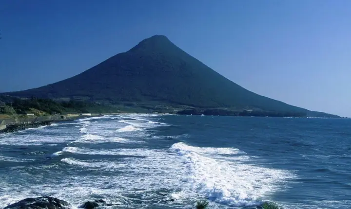
Mount Kaimon is a 924-meter active volcano in Ibusuki City, Kagoshima Prefecture, with a lava dome atop a conical volcanic edifice. Its symmetrical silhouette at the southern tip of the Satsuma Peninsula gives it the name Satsuma-Fuji. It lies within Kirishima-Kinkowan National Park. From Kaimon Sanroku Fureai Park, a single path about 4.6 km long spirals up the mountainside to the summit. The route has an elevation difference of 804 meters, making the climb comparable to much higher mountains. Rocky sections and ladders occur higher up. Clear days bring views of Yakushima, Sakurajima and the Kirishima Mountains.
Mount Kaimon at a glance
- Weather: The most settled day in the next 7 days is Mon, November 9: clear, gusts up to 8 m/s.
- Route: The shortest is Mount Kaimondake from Kaimon Sanroku Fureai Park: about 4 h 47 min, 7.8 km, about 790 m of climbing.
Mount Kaimon weather (hourly, 14 days)
Sunrise today 06:34, sunset 17:29
| Tue, 11/3 | Wed, 11/4 | Thu, 11/5 | Fri, 11/6 | Sat, 11/7 | Sun, 11/8 | Mon, 11/9 | Tue, 11/10 | Wed, 11/11 | Thu, 11/12 | Fri, 11/13 | Sat, 11/14 | Sun, 11/15 | Mon, 11/16 | Tue, 11/17 | |||||||||||||||||||||||||||||||||||||||||||||||||||||||||||||||||||||||
|---|---|---|---|---|---|---|---|---|---|---|---|---|---|---|---|---|---|---|---|---|---|---|---|---|---|---|---|---|---|---|---|---|---|---|---|---|---|---|---|---|---|---|---|---|---|---|---|---|---|---|---|---|---|---|---|---|---|---|---|---|---|---|---|---|---|---|---|---|---|---|---|---|---|---|---|---|---|---|---|---|---|---|---|---|---|
| Japan time | 15 | 17 | 19 | 21 | 23 | 1 | 3 | 5 | 7 | 9 | 11 | 13 | 15 | 18 | 21 | 0 | 3 | 6 | 9 | 12 | 15 | 18 | 21 | 0 | 3 | 6 | 9 | 12 | 15 | 18 | 21 | 0 | 3 | 6 | 9 | 12 | 15 | 18 | 21 | 0 | 3 | 6 | 9 | 12 | 15 | 18 | 21 | 0 | 3 | 6 | 9 | 15 | 21 | 3 | 9 | 15 | 21 | 3 | 9 | 15 | 21 | 3 | 9 | 15 | 21 | 3 | 9 | 15 | 21 | 3 | 9 | 15 | 21 | 3 | 9 | 15 | 21 | 3 | 9 | 15 | 21 | 3 | 9 | 15 | |
  |  |   |   | | | | | | |   |   | | | | |   |   | | |   |   | |  | | | | | | | | | | | | | | | | | | | | | | | | | | | | | | | | |   | | | | | | | | | | | | | | | | | | |   | |  | | | | | |   | ||
| Temperature | °C | 15° | 15° | 14° | 13° | 13° | 13° | 13° | 12° | 12° | 14° | 16° | 18° | 17° | 15° | 15° | 14° | 14° | 14° | 15° | 18° | 17° | 17° | 16° | 15° | 14° | 13° | 14° | 16° | 16° | 14° | 12° | 9° | 8° | 7° | 8° | 11° | 12° | 10° | 9° | 9° | 9° | 8° | 10° | 14° | 14° | 13° | 12° | 11° | 12° | 12° | 13° | 14° | 12° | 10° | 10° | 13° | 9° | 8° | 9° | 12° | 8° | 7° | 10° | 13° | 10° | 8° | 11° | 14° | 11° | 10° | 12° | 16° | 14° | 15° | 15° | 16° | 14° | 14° | 14° | 16° | 12° | 11° | 12° | 14° |
| Precipitation | mm | 0.2 | 0.3 | 0.9 | 0.3 | 0.1 | 0.1 | 0.3 | 2.1 | 17 | 17 | 0.2 | |||||||||||||||||||||||||||||||||||||||||||||||||||||||||||||||||||||||||
| New snow | cm | ||||||||||||||||||||||||||||||||||||||||||||||||||||||||||||||||||||||||||||||||||||
| Snow depth | cm | 0 | 0 | 0 | 0 | 0 | 0 | 0 | 0 | 0 | 0 | 0 | 0 | 0 | 0 | 0 | 0 | 0 | 0 | 0 | 0 | 0 | 0 | 0 | 0 | 0 | 0 | 0 | 0 | 0 | 0 | 0 | 0 | 0 | 0 | 0 | 0 | 0 | 0 | 0 | 0 | 0 | 0 | 0 | 0 | 0 | 0 | 0 | 0 | 0 | 0 | 0 | 0 | 0 | 0 | 0 | 0 | 0 | 0 | 0 | 0 | 0 | 0 | 0 | 0 | 0 | 0 | 0 | 0 | 0 | 0 | 0 | 0 | 0 | 0 | 0 | 0 | 0 | 0 | 0 | 0 | 0 | 0 | 0 | 0 |
| Wind | m/s | 4 | 2 | 0 | 4 | 4 | 5 | 5 | 5 | 5 | 5 | 5 | 4 | 6 | 5 | 4 | 4 | 4 | 3 | 2 | 2 | 6 | 6 | 5 | 5 | 6 | 6 | 6 | 6 | 7 | 6 | 6 | 6 | 6 | 6 | 7 | 5 | 4 | 3 | 3 | 3 | 4 | 5 | 5 | 5 | 4 | 4 | 4 | 4 | 4 | 4 | 4 | 4 | 4 | 5 | 7 | 6 | 7 | 5 | 5 | 3 | 4 | 2 | 3 | 2 | 4 | 3 | 4 | 2 | 4 | 5 | 4 | 6 | 5 | 5 | 7 | 5 | 7 | 5 | 4 | 5 | 3 | 2 | 3 | 3 |
| Wind gusts | m/s | 7 | 7 | 4 | 6 | 7 | 8 | 9 | 8 | 9 | 10 | 10 | 9 | 10 | 10 | 8 | 8 | 7 | 8 | 5 | 5 | 9 | 10 | 9 | 9 | 10 | 11 | 11 | 10 | 11 | 12 | 11 | 10 | 10 | 11 | 12 | 12 | 10 | 7 | 6 | 5 | 7 | 9 | 10 | 10 | 10 | 7 | 7 | 7 | 7 | 7 | 8 | 7 | 8 | 9 | 12 | 13 | 12 | 12 | 10 | 10 | 7 | 6 | 6 | 5 | 7 | 7 | 8 | 8 | 7 | 9 | 9 | 10 | 10 | 10 | 14 | 12 | 13 | 11 | 9 | 9 | 8 | 6 | 6 | 6 |
| Wind dir. | ↓ | ↓ | ↓ | ↓ | ↓ | ↓ | ↓ | ↓ | ↓ | ↓ | ↓ | ↓ | ↓ | ↓ | ↓ | ↓ | ↓ | ↓ | ↓ | ↓ | ↓ | ↓ | ↓ | ↓ | ↓ | ↓ | ↓ | ↓ | ↓ | ↓ | ↓ | ↓ | ↓ | ↓ | ↓ | ↓ | ↓ | ↓ | ↓ | ↓ | ↓ | ↓ | ↓ | ↓ | ↓ | ↓ | ↓ | ↓ | ↓ | ↓ | ↓ | ↓ | ↓ | ↓ | ↓ | ↓ | ↓ | ↓ | ↓ | ↓ | ↓ | ↓ | ↓ | ↓ | ↓ | ↓ | ↓ | ↓ | ↓ | ↓ | ↓ | ↓ | ↓ | ↓ | ↓ | ↓ | ↓ | ↓ | ↓ | ↓ | ↓ | ↓ | ↓ | ↓ | |
Mount Kaimon hiking routes
- Mount Kaimondake from Kaimon Sanroku Fureai Park 7.8 km · Ascent 793 m 開聞山麓ふれあい公園駐車場
- Mount Kaimon Return from Kaimon Foothill Fureai Park 7.7 km · Ascent 831 m 開聞山麓ふれあい公園駐車場
- Kaimon Station–Mount Kaimon Return 10.3 km · Ascent 884 m Kaimon (Station), 開聞駅 (Station), Kaimon-station (Bus stop)
Hiking times are estimates calculated from the terrain.
Huts, campsites and lodging near Mount Kaimon
Campsites
- かいもん山麓ふれあい公園・キャンプ場
Lists that include Mount Kaimon
100 Famous Japanese Mountains · Japan 200 Famous Mountains · Japan's 300 Famous Mountains · New 100 Famous Flower Mountains · New Japan 100 Famous Mountains · 100 Low Mountains of Japan · 100 Famous Hot Spring Mountains · 100 Fujis of Japan · Kyushu 100 Famous Mountains · Elevations of 1003 Mountains of Japan · 1000 Mountains of Japan
Mount Kaimon facts
- Also known as
- 薩摩富士 · Kaimondake
- Elevation
- 924 m
- Location
- Ibusuki, Kagoshima
31.179960, 130.528441 - National Park
- 霧島錦江湾国立公園
- Volcano
- Active volcano (開聞岳)
- Website
- www.ibusuki.or.jp
- Trail Map
- www.ibusuki.or.jp (PDF)
- Access Information
- www.ibusuki.or.jp
- Wikipedia
- ja.wikipedia.org