
Mount Daruma
達磨山
Izu, Shizuoka · Elevation 982 m
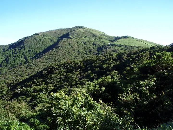
Mount Daruma (982 m) is the highest peak of the Daruma (Nekko-koshi) volcanic group in the northwestern Izu Peninsula, in Izu City, Shizuoka Prefecture. Within Fuji-Hakone-Izu National Park, its bamboo-grass summit gives a panoramic view of Mount Fuji across Suruga Bay — a vista famously painted by Yokoyama Taikan. The ridge walk from the Daruma Highland Rest House is one of Izu's most popular hiking routes and the peak is widely listed among Japan's hundred low-mountain selections.
Mount Daruma at a glance
- Weather: The most settled day in the next 7 days is Sun, November 8: cloudy, gusts up to 6 m/s. Wed, Nov 4, Fri, Nov 6: strong wind (gusts up to 17 m/s).
- Route: The shortest is Mount Kodatuma and Mount Kinkan Traverse from Asebigahara: about 1 h 46 min, 3.7 km, about 150 m of climbing.
Mount Daruma weather (hourly, 14 days)
Sunrise today 06:07, sunset 16:50
| Tue, 11/3 | Wed, 11/4 | Thu, 11/5 | Fri, 11/6 | Sat, 11/7 | Sun, 11/8 | Mon, 11/9 | Tue, 11/10 | Wed, 11/11 | Thu, 11/12 | Fri, 11/13 | Sat, 11/14 | Sun, 11/15 | Mon, 11/16 | Tue, 11/17 | |||||||||||||||||||||||||||||||||||||||||||||||||||||||||||||||||||||||
|---|---|---|---|---|---|---|---|---|---|---|---|---|---|---|---|---|---|---|---|---|---|---|---|---|---|---|---|---|---|---|---|---|---|---|---|---|---|---|---|---|---|---|---|---|---|---|---|---|---|---|---|---|---|---|---|---|---|---|---|---|---|---|---|---|---|---|---|---|---|---|---|---|---|---|---|---|---|---|---|---|---|---|---|---|---|
| Japan time | 15 | 17 | 19 | 21 | 23 | 1 | 3 | 5 | 7 | 9 | 11 | 13 | 15 | 18 | 21 | 0 | 3 | 6 | 9 | 12 | 15 | 18 | 21 | 0 | 3 | 6 | 9 | 12 | 15 | 18 | 21 | 0 | 3 | 6 | 9 | 12 | 15 | 18 | 21 | 0 | 3 | 6 | 9 | 12 | 15 | 18 | 21 | 0 | 3 | 6 | 9 | 15 | 21 | 3 | 9 | 15 | 21 | 3 | 9 | 15 | 21 | 3 | 9 | 15 | 21 | 3 | 9 | 15 | 21 | 3 | 9 | 15 | 21 | 3 | 9 | 15 | 21 | 3 | 9 | 15 | 21 | 3 | 9 | 15 | |
  |   |   | | |   | |   |   |   | | | | | | | | | |   | | | | | | | |  | |  | | | | | | | | |   | | | | |   | | | | | | | | | | | |   |   | | | | | | | | | | | | | | | | | | | | | | | | | | | | ||
| Temperature | °C | 14° | 12° | 11° | 10° | 10° | 10° | 10° | 9° | 9° | 10° | 10° | 10° | 9° | 8° | 8° | 9° | 9° | 10° | 13° | 18° | 15° | 13° | 11° | 10° | 11° | 13° | 15° | 18° | 18° | 15° | 13° | 11° | 10° | 9° | 11° | 13° | 14° | 9° | 9° | 7° | 6° | 6° | 10° | 12° | 12° | 8° | 7° | 8° | 8° | 8° | 9° | 11° | 8° | 6° | 8° | 11° | 7° | 9° | 10° | 12° | 5° | 4° | 9° | 9° | 6° | 6° | 9° | 12° | 6° | 4° | 7° | 10° | 6° | 6° | 11° | 11° | 12° | 12° | 15° | 17° | 10° | 7° | 8° | 8° |
| Precipitation | mm | 0.2 | 0.3 | 0.2 | 0.1 | 0.2 | 0.7 | 4.0 | 4.4 | 5 | 6 | 12 | 9 | 2.5 | 2.0 | 0.3 | 0.4 | 0.4 | 0.8 | 0.2 | 0.2 | 0.8 | 0.3 | 0.5 | 0.1 | 0.3 | 0.1 | 0.5 | 0.2 | 4.0 | 16 | 29 | 12 | ||||||||||||||||||||||||||||||||||||||||||||||||||||
| New snow | cm | ||||||||||||||||||||||||||||||||||||||||||||||||||||||||||||||||||||||||||||||||||||
| Snow depth | cm | 0 | 0 | 0 | 0 | 0 | 0 | 0 | 0 | 0 | 0 | 0 | 0 | 0 | 0 | 0 | 0 | 0 | 0 | 0 | 0 | 0 | 0 | 0 | 0 | 0 | 0 | 0 | 0 | 0 | 0 | 0 | 0 | 0 | 0 | 0 | 0 | 0 | 0 | 0 | 0 | 0 | 0 | 0 | 0 | 0 | 0 | 0 | 0 | 0 | 0 | 0 | 0 | 0 | 0 | 0 | 0 | 0 | 0 | 0 | 0 | 0 | 0 | 0 | 0 | 0 | 0 | 0 | 0 | 0 | 0 | 0 | 0 | 0 | 0 | 0 | 0 | 0 | 0 | 0 | 0 | 0 | 0 | 0 | 0 |
| Wind | m/s | 2 | 2 | 2 | 2 | 3 | 3 | 4 | 4 | 5 | 5 | 6 | 6 | 6 | 5 | 5 | 5 | 4 | 3 | 2 | 1 | 0 | 1 | 0 | 1 | 3 | 6 | 3 | 4 | 7 | 8 | 6 | 5 | 5 | 3 | 2 | 4 | 1 | 3 | 3 | 2 | 2 | 2 | 2 | 2 | 1 | 2 | 2 | 3 | 2 | 3 | 3 | 2 | 4 | 4 | 5 | 1 | 3 | 7 | 0 | 1 | 1 | 2 | 1 | 1 | 1 | 1 | 1 | 2 | 3 | 3 | 3 | 1 | 1 | 1 | 0 | 2 | 4 | 2 | 5 | 4 | 2 | 4 | 5 | 4 |
| Wind gusts | m/s | 9 | 6 | 6 | 6 | 7 | 8 | 11 | 11 | 12 | 14 | 15 | 17 | 16 | 16 | 17 | 16 | 14 | 11 | 9 | 6 | 5 | 4 | 3 | 4 | 8 | 15 | 16 | 10 | 16 | 19 | 19 | 14 | 12 | 12 | 9 | 11 | 11 | 10 | 9 | 7 | 5 | 5 | 6 | 6 | 6 | 6 | 6 | 7 | 6 | 6 | 7 | 8 | 10 | 11 | 13 | 13 | 8 | 17 | 23 | 9 | 5 | 6 | 7 | 6 | 4 | 5 | 5 | 6 | 7 | 8 | 8 | 8 | 5 | 4 | 4 | 9 | 12 | 18 | 13 | 14 | 14 | 9 | 12 | 13 |
| Wind dir. | ↓ | ↓ | ↓ | ↓ | ↓ | ↓ | ↓ | ↓ | ↓ | ↓ | ↓ | ↓ | ↓ | ↓ | ↓ | ↓ | ↓ | ↓ | ↓ | ↓ | ↓ | ↓ | ↓ | ↓ | ↓ | ↓ | ↓ | ↓ | ↓ | ↓ | ↓ | ↓ | ↓ | ↓ | ↓ | ↓ | ↓ | ↓ | ↓ | ↓ | ↓ | ↓ | ↓ | ↓ | ↓ | ↓ | ↓ | ↓ | ↓ | ↓ | ↓ | ↓ | ↓ | ↓ | ↓ | ↓ | ↓ | ↓ | ↓ | ↓ | ↓ | ↓ | ↓ | ↓ | ↓ | ↓ | ↓ | ↓ | ↓ | ↓ | ↓ | ↓ | ↓ | ↓ | ↓ | ↓ | ↓ | ↓ | ↓ | ↓ | ↓ | ↓ | ↓ | ↓ | |
Mount Daruma hiking routes
- Mount Kodatuma and Mount Kinkan Traverse from Asebigahara 3.7 km · Ascent 151 m Mt. Daruma → Muko Pass Parking Area, Heda Pass (Bus stop) (parking)
- Mount Kinkan and Mount Daruma from Darumayama Highlands Out-and-Back 8.9 km · Ascent 629 m Daurumayama Kogen Resthouse (Bus stop) (parking)
Hiking times are estimates calculated from the terrain.
Huts, campsites and lodging near Mount Daruma
Campsites
- 市民の森
- オートキャンプもぐら
Lists that include Mount Daruma
100 Mountains of Shizuoka · Elevations of 1003 Mountains of Japan · 1000 Mountains of Japan
Mount Daruma facts
- Elevation
- 982 m
- Location
- Izu, Shizuoka
34.955001, 138.839293 - National Park
- 富士箱根伊豆国立公園
- Website
- kanko.city.izu.shizuoka.jp
- Trail Map
- kanko.city.izu.shizuoka.jp (PDF)
- Wikipedia
- ja.wikipedia.org