
Mount Ame
雨山
Kumatori, Osaka / Izumisano, Osaka · Elevation 312 m
Mount Ame (312 m) rises in southeastern Kumatori, Sennan District, Osaka Prefecture, forming a foothill of the northern Izumi Range. The ruins of Ameyama Castle, a Nanboku-cho period mountain castle, remain on its slopes. Hiking trails through Okuyama-Ameyama Nature Park, designated one of Osaka's 100 Green Selections, loop around Eiraku Dam and offer views of the Izumi Katsuragi range, Osaka Bay and Kansai International Airport. The peak is listed in the Osaka 50 Mountains and the Osaka Prefecture mountain guidebook.
Mount Ame at a glance
- Weather: The most settled day in the next 7 days is Mon, November 9: clear, gusts up to 6 m/s.
- Route: The shortest is Mount Ameyama Loop via Eiraku Dam's East and West Hiking Trails: about 2 h 39 min, 5.6 km, about 330 m of climbing.
Mount Ame weather (hourly, 14 days)
Sunrise today 06:20, sunset 17:05
| Tue, 11/3 | Wed, 11/4 | Thu, 11/5 | Fri, 11/6 | Sat, 11/7 | Sun, 11/8 | Mon, 11/9 | Tue, 11/10 | Wed, 11/11 | Thu, 11/12 | Fri, 11/13 | Sat, 11/14 | Sun, 11/15 | Mon, 11/16 | Tue, 11/17 | |||||||||||||||||||||||||||||||||||||||||||||||||||||||||||||||||||||||
|---|---|---|---|---|---|---|---|---|---|---|---|---|---|---|---|---|---|---|---|---|---|---|---|---|---|---|---|---|---|---|---|---|---|---|---|---|---|---|---|---|---|---|---|---|---|---|---|---|---|---|---|---|---|---|---|---|---|---|---|---|---|---|---|---|---|---|---|---|---|---|---|---|---|---|---|---|---|---|---|---|---|---|---|---|---|
| Japan time | 21 | 23 | 1 | 3 | 5 | 7 | 9 | 11 | 13 | 15 | 17 | 19 | 21 | 0 | 3 | 6 | 9 | 12 | 15 | 18 | 21 | 0 | 3 | 6 | 9 | 12 | 15 | 18 | 21 | 0 | 3 | 6 | 9 | 12 | 15 | 18 | 21 | 0 | 3 | 6 | 9 | 12 | 15 | 18 | 21 | 0 | 3 | 6 | 9 | 12 | 15 | 21 | 3 | 9 | 15 | 21 | 3 | 9 | 15 | 21 | 3 | 9 | 15 | 21 | 3 | 9 | 15 | 21 | 3 | 9 | 15 | 21 | 3 | 9 | 15 | 21 | 3 | 9 | 15 | 21 | 3 | 9 | 15 | 21 | |
  |   | | | |   |   | | | | | | |   | |   |   | |   |   | |   | | | | |  | | | | | | |   | | |  | | | | | | | | | | | | | | | |   | | | | | | | |  | | | | | | | | | | | | | |   | | | | | |  | | | | ||
| Temperature | °C | 14° | 12° | 11° | 11° | 11° | 12° | 14° | 15° | 16° | 17° | 16° | 15° | 14° | 14° | 14° | 14° | 16° | 19° | 19° | 17° | 16° | 17° | 17° | 14° | 16° | 18° | 19° | 16° | 15° | 13° | 11° | 10° | 13° | 13° | 14° | 11° | 10° | 9° | 9° | 8° | 10° | 13° | 13° | 11° | 10° | 9° | 8° | 9° | 13° | 14° | 15° | 11° | 8° | 13° | 16° | 12° | 9° | 11° | 13° | 9° | 6° | 11° | 13° | 7° | 9° | 12° | 13° | 9° | 6° | 11° | 15° | 9° | 8° | 15° | 18° | 15° | 16° | 16° | 17° | 11° | 7° | 10° | 13° | 8° |
| Precipitation | mm | 1.2 | 0.2 | 1.0 | 0.2 | 0.4 | 2.8 | 2.2 | 0.9 | 0.5 | 0.9 | 0.4 | 0.2 | 0.3 | 0.4 | 0.4 | 0.7 | 3.0 | 14 | 2.4 | 0.9 | ||||||||||||||||||||||||||||||||||||||||||||||||||||||||||||||||
| New snow | cm | – | – | – | |||||||||||||||||||||||||||||||||||||||||||||||||||||||||||||||||||||||||||||||||
| Snow depth | cm | 0 | 0 | 0 | 0 | 0 | 0 | 0 | 0 | 0 | 0 | 0 | 0 | 0 | 0 | 0 | 0 | 0 | 0 | 0 | 0 | 0 | 0 | 0 | 0 | 0 | 0 | 0 | 0 | 0 | 0 | 0 | 0 | 0 | 0 | 0 | 0 | 0 | 0 | 0 | 0 | 0 | 0 | 0 | 0 | 0 | 0 | 0 | 0 | 0 | 0 | 0 | 0 | 0 | 0 | 0 | 0 | 0 | 0 | 0 | 0 | 0 | 0 | 0 | 0 | 0 | 0 | 0 | 0 | 0 | 0 | 0 | 0 | 0 | 0 | 0 | 0 | 0 | 0 | 0 | 0 | 0 | 0 | 0 | 0 |
| Wind | m/s | 3 | 2 | 2 | 2 | 3 | 3 | 3 | 3 | 3 | 3 | 1 | 1 | 1 | 1 | 1 | 1 | 0 | 1 | 1 | 1 | 2 | 4 | 4 | 3 | 4 | 5 | 5 | 4 | 5 | 5 | 4 | 3 | 5 | 4 | 5 | 5 | 4 | 3 | 4 | 4 | 4 | 4 | 4 | 3 | 2 | 1 | 1 | 2 | 1 | 2 | 2 | 1 | 1 | 2 | 3 | 5 | 5 | 6 | 6 | 3 | 1 | 1 | 2 | 1 | 1 | 4 | 5 | 3 | 2 | 2 | 1 | 1 | 2 | 1 | 2 | 1 | 2 | 4 | 5 | 4 | 3 | 3 | 2 | 2 |
| Wind gusts | m/s | 7 | 7 | 6 | 6 | 6 | 7 | 7 | 8 | 8 | 8 | 6 | 3 | 3 | 3 | 3 | 4 | 5 | 4 | 5 | 3 | 6 | 10 | 11 | 10 | 10 | 12 | 15 | 12 | 12 | 12 | 12 | 10 | 13 | 13 | 13 | 13 | 11 | 9 | 8 | 10 | 9 | 11 | 10 | 8 | 6 | 5 | 3 | 3 | 4 | 6 | 6 | 6 | 3 | 5 | 9 | 11 | 13 | 14 | 15 | 15 | 7 | 4 | 7 | 5 | 4 | 10 | 13 | 11 | 7 | 5 | 6 | 3 | 5 | 6 | 6 | 8 | 8 | 10 | 12 | 13 | 10 | 8 | 9 | 6 |
| Wind dir. | ↓ | ↓ | ↓ | ↓ | ↓ | ↓ | ↓ | ↓ | ↓ | ↓ | ↓ | ↓ | ↓ | ↓ | ↓ | ↓ | ↓ | ↓ | ↓ | ↓ | ↓ | ↓ | ↓ | ↓ | ↓ | ↓ | ↓ | ↓ | ↓ | ↓ | ↓ | ↓ | ↓ | ↓ | ↓ | ↓ | ↓ | ↓ | ↓ | ↓ | ↓ | ↓ | ↓ | ↓ | ↓ | ↓ | ↓ | ↓ | ↓ | ↓ | ↓ | ↓ | ↓ | ↓ | ↓ | ↓ | ↓ | ↓ | ↓ | ↓ | ↓ | ↓ | ↓ | ↓ | ↓ | ↓ | ↓ | ↓ | ↓ | ↓ | ↓ | ↓ | ↓ | ↓ | ↓ | ↓ | ↓ | ↓ | ↓ | ↓ | ↓ | ↓ | ↓ | ↓ | |
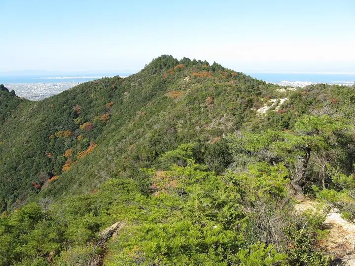
Mount Ame hiking routes
Hiking times are estimates calculated from the terrain.
Huts, campsites and lodging near Mount Ame
Lodging
- 犬鳴温泉センター
- 大阪府立少年自然の家
- OSAKA KANSAI AIRPORT HOTEL
- 水間荘
Lists that include Mount Ame
Mount Ame facts
- Elevation
- 312 m
- Location
- Kumatori, Osaka / Izumisano, Osaka
34.367922, 135.365869 - Website
- www.town.kumatori.lg.jp
- Wikipedia
- ja.wikipedia.org