
Mount Amagoi
雨乞山
Tahara, Aichi · Elevation 233 m
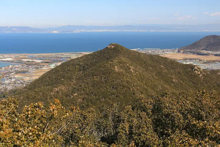
Mount Amagoi is a 233 m peak in the central Atsumi Peninsula of Tahara City, Aichi Prefecture, whose summit lies within the third-class special zone of Mikawa Bay Quasi-National Park. Between it and neighbouring Mount Oyama spreads the Nagusa Shidekobushi natural habitat, a national natural monument. The Atsumi Trail linking the two peaks is laid out by the Atsumi Peninsula Hiking Club, and Tahara City and the Atsumi Peninsula Tourism Bureau publish the Tahara Alps trekking map. The mountain is included in both the Atsumi Peninsula 10 Mountains and the Aichi 130 Mountains lists.
Mount Amagoi at a glance
- Weather: The most settled day in the next 7 days is Wed, November 4: cloudy, gusts up to 8 m/s. Fri, Nov 6, Sat, Nov 7, Sun, Nov 8: strong wind (gusts up to 22 m/s).
Mount Amagoi weather (hourly, 14 days)
Sunrise today 06:13, sunset 16:57
| Tue, 11/3 | Wed, 11/4 | Thu, 11/5 | Fri, 11/6 | Sat, 11/7 | Sun, 11/8 | Mon, 11/9 | Tue, 11/10 | Wed, 11/11 | Thu, 11/12 | Fri, 11/13 | Sat, 11/14 | Sun, 11/15 | Mon, 11/16 | Tue, 11/17 | |||||||||||||||||||||||||||||||||||||||||||||||||||||||||||||||||||||||
|---|---|---|---|---|---|---|---|---|---|---|---|---|---|---|---|---|---|---|---|---|---|---|---|---|---|---|---|---|---|---|---|---|---|---|---|---|---|---|---|---|---|---|---|---|---|---|---|---|---|---|---|---|---|---|---|---|---|---|---|---|---|---|---|---|---|---|---|---|---|---|---|---|---|---|---|---|---|---|---|---|---|---|---|---|---|
| Japan time | 15 | 17 | 19 | 21 | 23 | 1 | 3 | 5 | 7 | 9 | 11 | 13 | 15 | 18 | 21 | 0 | 3 | 6 | 9 | 12 | 15 | 18 | 21 | 0 | 3 | 6 | 9 | 12 | 15 | 18 | 21 | 0 | 3 | 6 | 9 | 12 | 15 | 18 | 21 | 0 | 3 | 6 | 9 | 12 | 15 | 18 | 21 | 0 | 3 | 6 | 9 | 15 | 21 | 3 | 9 | 15 | 21 | 3 | 9 | 15 | 21 | 3 | 9 | 15 | 21 | 3 | 9 | 15 | 21 | 3 | 9 | 15 | 21 | 3 | 9 | 15 | 21 | 3 | 9 | 15 | 21 | 3 | 9 | 15 | |
 |  |   | | | | | |   |   | | |   |   | | | |   |   | |   |   | | | | | | | |  | | | | | | | | | | | | | | | | | | | | | | | | | | |   | | | |   |  | | | | | | | | | | | | | | | | | | |  | | |   | ||
| Temperature | °C | 19° | 19° | 17° | 16° | 15° | 14° | 14° | 13° | 13° | 14° | 16° | 17° | 16° | 15° | 15° | 15° | 14° | 15° | 17° | 19° | 18° | 18° | 17° | 17° | 16° | 16° | 18° | 19° | 20° | 17° | 16° | 14° | 13° | 13° | 13° | 14° | 14° | 13° | 11° | 11° | 11° | 11° | 11° | 14° | 15° | 14° | 13° | 13° | 12° | 12° | 13° | 17° | 15° | 12° | 13° | 16° | 14° | 11° | 11° | 13° | 11° | 9° | 10° | 14° | 14° | 12° | 13° | 15° | 11° | 9° | 11° | 14° | 14° | 14° | 15° | 16° | 17° | 17° | 16° | 19° | 13° | 11° | 10° | 12° |
| Precipitation | mm | 0.3 | 0.6 | 5 | 6 | 3.5 | 1.0 | 0.4 | 0.1 | 2.5 | 0.4 | 0.7 | 2.3 | 10 | 14 | 2.7 | |||||||||||||||||||||||||||||||||||||||||||||||||||||||||||||||||||||
| New snow | cm | ||||||||||||||||||||||||||||||||||||||||||||||||||||||||||||||||||||||||||||||||||||
| Snow depth | cm | 0 | 0 | 0 | 0 | 0 | 0 | 0 | 0 | 0 | 0 | 0 | 0 | 0 | 0 | 0 | 0 | 0 | 0 | 0 | 0 | 0 | 0 | 0 | 0 | 0 | 0 | 0 | 0 | 0 | 0 | 0 | 0 | 0 | 0 | 0 | 0 | 0 | 0 | 0 | 0 | 0 | 0 | 0 | 0 | 0 | 0 | 0 | 0 | 0 | 0 | 0 | 0 | 0 | 0 | 0 | 0 | 0 | 0 | 0 | 0 | 0 | 0 | 0 | 0 | 0 | 0 | 0 | 0 | 0 | 0 | 0 | 0 | 0 | 0 | 0 | 0 | 0 | 0 | 0 | 0 | 0 | 0 | 0 | 0 |
| Wind | m/s | 6 | 4 | 5 | 6 | 6 | 5 | 5 | 4 | 3 | 2 | 1 | 1 | 1 | 7 | 6 | 4 | 5 | 6 | 4 | 3 | 1 | 0 | 1 | 1 | 2 | 5 | 9 | 9 | 9 | 11 | 9 | 11 | 12 | 11 | 11 | 12 | 12 | 11 | 10 | 8 | 10 | 9 | 8 | 6 | 5 | 4 | 4 | 5 | 5 | 5 | 5 | 7 | 6 | 1 | 1 | 1 | 7 | 13 | 12 | 12 | 11 | 8 | 6 | 5 | 6 | 6 | 8 | 10 | 9 | 5 | 2 | 2 | 4 | 5 | 6 | 5 | 4 | 1 | 5 | 12 | 10 | 9 | 6 | 3 |
| Wind gusts | m/s | 12 | 10 | 9 | 10 | 10 | 9 | 10 | 9 | 8 | 6 | 5 | 5 | 4 | 11 | 11 | 11 | 8 | 9 | 10 | 8 | 6 | 3 | 2 | 3 | 3 | 10 | 15 | 17 | 17 | 18 | 18 | 18 | 20 | 20 | 20 | 22 | 21 | 20 | 18 | 16 | 17 | 17 | 15 | 14 | 12 | 9 | 7 | 9 | 9 | 9 | 9 | 12 | 12 | 9 | 5 | 5 | 13 | 22 | 21 | 22 | 21 | 18 | 14 | 11 | 12 | 13 | 13 | 18 | 19 | 16 | 8 | 5 | 7 | 8 | 10 | 10 | 11 | 9 | 10 | 20 | 21 | 19 | 16 | 11 |
| Wind dir. | ↓ | ↓ | ↓ | ↓ | ↓ | ↓ | ↓ | ↓ | ↓ | ↓ | ↓ | ↓ | ↓ | ↓ | ↓ | ↓ | ↓ | ↓ | ↓ | ↓ | ↓ | ↓ | ↓ | ↓ | ↓ | ↓ | ↓ | ↓ | ↓ | ↓ | ↓ | ↓ | ↓ | ↓ | ↓ | ↓ | ↓ | ↓ | ↓ | ↓ | ↓ | ↓ | ↓ | ↓ | ↓ | ↓ | ↓ | ↓ | ↓ | ↓ | ↓ | ↓ | ↓ | ↓ | ↓ | ↓ | ↓ | ↓ | ↓ | ↓ | ↓ | ↓ | ↓ | ↓ | ↓ | ↓ | ↓ | ↓ | ↓ | ↓ | ↓ | ↓ | ↓ | ↓ | ↓ | ↓ | ↓ | ↓ | ↓ | ↓ | ↓ | ↓ | ↓ | ↓ | |
Huts, campsites and lodging near Mount Amagoi
Lodging
- 浪漫の宿 井筒楼
- 和味の宿 角上楼
Lists that include Mount Amagoi
130 Mountains of Aichi · Atsumi Peninsula 10 Famous Mountains
Mount Amagoi facts
- Elevation
- 233 m
- Location
- Tahara, Aichi
34.629558, 137.141084 - National Park
- 三河湾国定公園
- Website
- www.city.tahara.aichi.jp
- Trail Map
- www.taharakankou.gr.jp (PDF)
- Wikipedia
- ja.wikipedia.org