
Mt. Tamakisan
玉置山
Totsukawa, Nara · Elevation 1,077 m
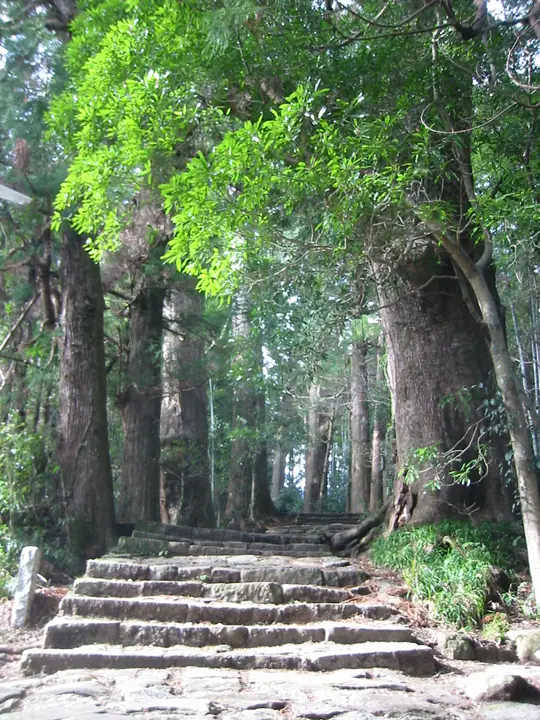
Tamakisan is a 1,076.8 m quartz-porphyry peak at the southern end of the Ōmine Range in Totsukawa Village, Yoshino District, Nara Prefecture. As the southernmost station on the Ōmine Okugakemichi pilgrim trail — a component of the UNESCO World Heritage "Sacred Sites and Pilgrimage Routes in the Kii Mountain Range" — its ninth station carries Tamaki Shrine, said to be one of the oldest in Japan, ringed by a Nara-prefectural-monument stand of giant cedars including the c. 3,000-year-old Jindai-sugi. The peak appears on lists such as the "Kansai Hyakumeizan", "Kinki Hyakumeizan" and "Nihon no Yama 1000", and lies within Yoshino-Kumano National Park.
Mt. Tamakisan at a glance
- Weather: The most settled day in the next 7 days is Sun, November 8: clear, gusts up to 7 m/s. Sat, Nov 7: strong wind (gusts up to 15 m/s).
Mt. Tamakisan weather (hourly, 14 days)
Sunrise today 06:17, sunset 17:03
| Tue, 11/3 | Wed, 11/4 | Thu, 11/5 | Fri, 11/6 | Sat, 11/7 | Sun, 11/8 | Mon, 11/9 | Tue, 11/10 | Wed, 11/11 | Thu, 11/12 | Fri, 11/13 | Sat, 11/14 | Sun, 11/15 | Mon, 11/16 | Tue, 11/17 | |||||||||||||||||||||||||||||||||||||||||||||||||||||||||||||||||||||||
|---|---|---|---|---|---|---|---|---|---|---|---|---|---|---|---|---|---|---|---|---|---|---|---|---|---|---|---|---|---|---|---|---|---|---|---|---|---|---|---|---|---|---|---|---|---|---|---|---|---|---|---|---|---|---|---|---|---|---|---|---|---|---|---|---|---|---|---|---|---|---|---|---|---|---|---|---|---|---|---|---|---|---|---|---|---|
| Japan time | 15 | 17 | 19 | 21 | 23 | 1 | 3 | 5 | 7 | 9 | 11 | 13 | 15 | 18 | 21 | 0 | 3 | 6 | 9 | 12 | 15 | 18 | 21 | 0 | 3 | 6 | 9 | 12 | 15 | 18 | 21 | 0 | 3 | 6 | 9 | 12 | 15 | 18 | 21 | 0 | 3 | 6 | 9 | 12 | 15 | 18 | 21 | 0 | 3 | 6 | 9 | 15 | 21 | 3 | 9 | 15 | 21 | 3 | 9 | 15 | 21 | 3 | 9 | 15 | 21 | 3 | 9 | 15 | 21 | 3 | 9 | 15 | 21 | 3 | 9 | 15 | 21 | 3 | 9 | 15 | 21 | 3 | 9 | 15 | |
 |   |   |   | | | | |   | |   |   | |   | | | | | | | | | | |   | | | | | | | | | | | | | |  | | | | | | | | |   | | | | | | | | | | | | | |  | | | | | | | | | | | | | | |   |   | |   | |  | | | ||
| Temperature | °C | 15° | 11° | 8° | 8° | 7° | 6° | 8° | 7° | 7° | 12° | 15° | 13° | 12° | 11° | 11° | 12° | 11° | 10° | 15° | 16° | 16° | 12° | 9° | 10° | 12° | 12° | 14° | 16° | 15° | 11° | 10° | 8° | 6° | 5° | 8° | 10° | 9° | 5° | 3° | 2° | 1° | 1° | 8° | 13° | 11° | 5° | 5° | 4° | 3° | 4° | 11° | 13° | 4° | 3° | 10° | 12° | 5° | 4° | 6° | 8° | 2° | 0° | 7° | 11° | 1° | 2° | 8° | 9° | 2° | -1° | 8° | 12° | 3° | 4° | 10° | 11° | 9° | 10° | 13° | 14° | 7° | 3° | 7° | 12° |
| Precipitation | mm | 0.1 | 0.1 | 0.7 | 0.4 | 0.5 | 2.6 | 4.2 | 14 | 0.1 | 0.1 | ||||||||||||||||||||||||||||||||||||||||||||||||||||||||||||||||||||||||||
| New snow | cm | ||||||||||||||||||||||||||||||||||||||||||||||||||||||||||||||||||||||||||||||||||||
| Snow depth | cm | 0 | 0 | 0 | 0 | 0 | 0 | 0 | 0 | 0 | 0 | 0 | 0 | 0 | 0 | 0 | 0 | 0 | 0 | 0 | 0 | 0 | 0 | 0 | 0 | 0 | 0 | 0 | 0 | 0 | 0 | 0 | 0 | 0 | 0 | 0 | 0 | 0 | 0 | 0 | 0 | 0 | 0 | 0 | 0 | 0 | 0 | 0 | 0 | 0 | 0 | 0 | 0 | 0 | 0 | 0 | 0 | 0 | 0 | 0 | 0 | 0 | 0 | 0 | 0 | 0 | 0 | 0 | 0 | 0 | 0 | 0 | 0 | 0 | 0 | 0 | 0 | 0 | 0 | 0 | 0 | 0 | 0 | 0 | 0 |
| Wind | m/s | 2 | 2 | 2 | 2 | 2 | 2 | 2 | 2 | 2 | 1 | 3 | 3 | 2 | 1 | 2 | 1 | 1 | 1 | 1 | 2 | 1 | 0 | 1 | 2 | 1 | 5 | 4 | 5 | 5 | 4 | 4 | 5 | 5 | 5 | 5 | 5 | 5 | 3 | 2 | 1 | 2 | 1 | 2 | 2 | 2 | 2 | 1 | 1 | 2 | 2 | 2 | 3 | 2 | 2 | 0 | 3 | 4 | 6 | 5 | 5 | 2 | 2 | 1 | 3 | 2 | 2 | 3 | 5 | 3 | 2 | 0 | 1 | 1 | 1 | 0 | 1 | 1 | 2 | 3 | 4 | 4 | 3 | 3 | 0 |
| Wind gusts | m/s | 7 | 7 | 7 | 6 | 5 | 5 | 6 | 6 | 5 | 5 | 9 | 9 | 8 | 8 | 7 | 7 | 5 | 3 | 4 | 7 | 6 | 3 | 3 | 6 | 6 | 13 | 14 | 13 | 13 | 13 | 12 | 15 | 15 | 15 | 15 | 15 | 14 | 12 | 10 | 8 | 6 | 7 | 6 | 7 | 7 | 6 | 5 | 4 | 4 | 6 | 6 | 10 | 8 | 5 | 5 | 8 | 11 | 18 | 19 | 16 | 14 | 8 | 6 | 8 | 7 | 7 | 8 | 14 | 14 | 8 | 5 | 5 | 4 | 3 | 4 | 6 | 7 | 8 | 12 | 12 | 12 | 12 | 10 | 8 |
| Wind dir. | ↓ | ↓ | ↓ | ↓ | ↓ | ↓ | ↓ | ↓ | ↓ | ↓ | ↓ | ↓ | ↓ | ↓ | ↓ | ↓ | ↓ | ↓ | ↓ | ↓ | ↓ | ↓ | ↓ | ↓ | ↓ | ↓ | ↓ | ↓ | ↓ | ↓ | ↓ | ↓ | ↓ | ↓ | ↓ | ↓ | ↓ | ↓ | ↓ | ↓ | ↓ | ↓ | ↓ | ↓ | ↓ | ↓ | ↓ | ↓ | ↓ | ↓ | ↓ | ↓ | ↓ | ↓ | ↓ | ↓ | ↓ | ↓ | ↓ | ↓ | ↓ | ↓ | ↓ | ↓ | ↓ | ↓ | ↓ | ↓ | ↓ | ↓ | ↓ | ↓ | ↓ | ↓ | ↓ | ↓ | ↓ | ↓ | ↓ | ↓ | ↓ | ↓ | ↓ | ↓ | |
Lists that include Mt. Tamakisan
Kansai 100 Famous Mountains · Kinki 100 Famous Mountains · Nara 100 Mountains to Explore · Ōmine Okugakemichi · Elevations of 1003 Mountains of Japan · 1000 Mountains of Japan
Mt. Tamakisan facts
- Elevation
- 1,077 m
- Location
- Totsukawa, Nara
33.926590, 135.831614 - National Park
- 吉野熊野国立公園
- Website
- tamakijinja.or.jp
- Trail Map
- www.vill.totsukawa.lg.jp
- Access Information
- tamakijinja.or.jp
- Wikipedia
- ja.wikipedia.org