
Mt. Shijikisan
志々伎山
Hirado, Nagasaki · Elevation 347 m
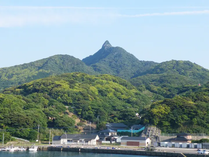
A 347.2-meter old-andesite spire at the southern tip of Hirado Island in Hirado City, Nagasaki Prefecture. Its sharply pointed silhouette has served seafarers as a navigation landmark for centuries and supports the upper sanctuary of Shijiki Shrine — a shikinai-sha named in the Heian-era Engishiki registry whose four sub-shrines (Upper, Middle, Lower and Offshore) line the slopes. A paved road climbs to mid-slope, after which a one-hour trail reaches a summit that commands a sweeping view of Uku Island, Ojika Island and the Gotō Archipelago. The peak is No. 67 in the Japan Islands Centre's "100 Island Mountains" and is featured in the 九州百名山 and the Bunken Tozan guide of Nagasaki mountains.
Mt. Shijikisan at a glance
- Weather: The most settled day in the next 7 days is Sun, November 8: clear, gusts up to 10 m/s. Sat, Nov 7: strong wind (gusts up to 16 m/s).
Mt. Shijikisan weather (hourly, 14 days)
Sunrise today 06:42, sunset 17:30
| Tue, 11/3 | Wed, 11/4 | Thu, 11/5 | Fri, 11/6 | Sat, 11/7 | Sun, 11/8 | Mon, 11/9 | Tue, 11/10 | Wed, 11/11 | Thu, 11/12 | Fri, 11/13 | Sat, 11/14 | Sun, 11/15 | Mon, 11/16 | Tue, 11/17 | |||||||||||||||||||||||||||||||||||||||||||||||||||||||||||||||||||||||
|---|---|---|---|---|---|---|---|---|---|---|---|---|---|---|---|---|---|---|---|---|---|---|---|---|---|---|---|---|---|---|---|---|---|---|---|---|---|---|---|---|---|---|---|---|---|---|---|---|---|---|---|---|---|---|---|---|---|---|---|---|---|---|---|---|---|---|---|---|---|---|---|---|---|---|---|---|---|---|---|---|---|---|---|---|---|
| Japan time | 15 | 17 | 19 | 21 | 23 | 1 | 3 | 5 | 7 | 9 | 11 | 13 | 15 | 18 | 21 | 0 | 3 | 6 | 9 | 12 | 15 | 18 | 21 | 0 | 3 | 6 | 9 | 12 | 15 | 18 | 21 | 0 | 3 | 6 | 9 | 12 | 15 | 18 | 21 | 0 | 3 | 6 | 9 | 12 | 15 | 18 | 21 | 0 | 3 | 6 | 9 | 15 | 21 | 3 | 9 | 15 | 21 | 3 | 9 | 15 | 21 | 3 | 9 | 15 | 21 | 3 | 9 | 15 | 21 | 3 | 9 | 15 | 21 | 3 | 9 | 15 | 21 | 3 | 9 | 15 | 21 | 3 | 9 | 15 | |
  | |   | | | | | |   | | | |   | | | |   |   | | |   |   |   |  | | |  | | | | | | | | | | | | | | | | | | | | | | | | | |   | | | | | |   | | | | | |  | | | | | | | | | |   | | | | | | | | | | ||
| Temperature | °C | 17° | 17° | 17° | 17° | 17° | 17° | 16° | 16° | 16° | 16° | 16° | 17° | 17° | 17° | 18° | 18° | 17° | 17° | 18° | 20° | 20° | 19° | 18° | 18° | 17° | 17° | 17° | 16° | 15° | 15° | 15° | 13° | 12° | 11° | 11° | 11° | 12° | 12° | 12° | 13° | 13° | 12° | 13° | 14° | 15° | 15° | 15° | 15° | 15° | 16° | 15° | 15° | 14° | 13° | 13° | 13° | 14° | 14° | 12° | 13° | 13° | 13° | 13° | 14° | 14° | 13° | 13° | 16° | 15° | 14° | 14° | 16° | 17° | 17° | 18° | 18° | 17° | 17° | 16° | 16° | 15° | 14° | 14° | 15° |
| Precipitation | mm | 0.7 | 0.3 | 0.4 | 3.4 | 0.9 | 0.2 | 5 | 6 | 13 | 1.4 | 0.4 | 0.2 | 0.1 | |||||||||||||||||||||||||||||||||||||||||||||||||||||||||||||||||||||||
| New snow | cm | ||||||||||||||||||||||||||||||||||||||||||||||||||||||||||||||||||||||||||||||||||||
| Snow depth | cm | 0 | 0 | 0 | 0 | 0 | 0 | 0 | 0 | 0 | 0 | 0 | 0 | 0 | 0 | 0 | 0 | 0 | 0 | 0 | 0 | 0 | 0 | 0 | 0 | 0 | 0 | 0 | 0 | 0 | 0 | 0 | 0 | 0 | 0 | 0 | 0 | 0 | 0 | 0 | 0 | 0 | 0 | 0 | 0 | 0 | 0 | 0 | 0 | 0 | 0 | 0 | 0 | 0 | 0 | 0 | 0 | 0 | 0 | 0 | 0 | 0 | 0 | 0 | 0 | 0 | 0 | 0 | 0 | 0 | 0 | 0 | 0 | 0 | 0 | 0 | 0 | 0 | 0 | 0 | 0 | 0 | 0 | 0 | 0 |
| Wind | m/s | 8 | 8 | 8 | 8 | 9 | 9 | 9 | 8 | 9 | 7 | 4 | 3 | 4 | 7 | 6 | 6 | 6 | 7 | 9 | 10 | 8 | 10 | 8 | 9 | 10 | 11 | 10 | 10 | 8 | 8 | 8 | 11 | 12 | 12 | 11 | 9 | 8 | 7 | 7 | 6 | 7 | 7 | 5 | 5 | 5 | 6 | 4 | 4 | 4 | 8 | 7 | 7 | 6 | 7 | 9 | 11 | 10 | 8 | 7 | 6 | 4 | 2 | 1 | 4 | 4 | 3 | 4 | 8 | 7 | 4 | 5 | 3 | 6 | 9 | 13 | 5 | 7 | 7 | 8 | 8 | 9 | 10 | 9 | 9 |
| Wind gusts | m/s | 12 | 11 | 11 | 11 | 12 | 12 | 12 | 12 | 12 | 12 | 10 | 5 | 5 | 9 | 9 | 9 | 8 | 10 | 12 | 15 | 13 | 13 | 14 | 13 | 13 | 15 | 14 | 14 | 14 | 11 | 12 | 15 | 17 | 17 | 16 | 14 | 13 | 11 | 10 | 10 | 9 | 10 | 10 | 8 | 9 | 8 | 8 | 6 | 7 | 11 | 11 | 10 | 11 | 10 | 13 | 15 | 15 | 13 | 13 | 10 | 9 | 6 | 5 | 6 | 6 | 7 | 7 | 10 | 11 | 11 | 7 | 7 | 8 | 12 | 18 | 17 | 10 | 10 | 12 | 11 | 13 | 14 | 14 | 12 |
| Wind dir. | ↓ | ↓ | ↓ | ↓ | ↓ | ↓ | ↓ | ↓ | ↓ | ↓ | ↓ | ↓ | ↓ | ↓ | ↓ | ↓ | ↓ | ↓ | ↓ | ↓ | ↓ | ↓ | ↓ | ↓ | ↓ | ↓ | ↓ | ↓ | ↓ | ↓ | ↓ | ↓ | ↓ | ↓ | ↓ | ↓ | ↓ | ↓ | ↓ | ↓ | ↓ | ↓ | ↓ | ↓ | ↓ | ↓ | ↓ | ↓ | ↓ | ↓ | ↓ | ↓ | ↓ | ↓ | ↓ | ↓ | ↓ | ↓ | ↓ | ↓ | ↓ | ↓ | ↓ | ↓ | ↓ | ↓ | ↓ | ↓ | ↓ | ↓ | ↓ | ↓ | ↓ | ↓ | ↓ | ↓ | ↓ | ↓ | ↓ | ↓ | ↓ | ↓ | ↓ | ↓ | |
Lists that include Mt. Shijikisan
Mt. Shijikisan facts
- Elevation
- 347 m
- Location
- Hirado, Nagasaki
33.175213, 129.372688 - Website
- www.hirado-net.com
- Trail Map
- www.hirado-net.com (PDF)
- Access Information
- www.hirado-net.com
- Wikipedia
- ja.wikipedia.org