
Mt. Saru
猿山
Wajima, Ishikawa · Elevation 332 m
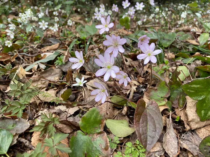
Mt. Saru (332 m) rises on the Noto Peninsula's western coast in Monzen-machi, Wajima City, Ishikawa, designated as a Special Zone within Noto-hantō Quasi-National Park. Cape Saruyama, where the mountain meets the Japan Sea, is crowned by the 1916 Saruyama Lighthouse and is one of Japan's foremost native habitats for yuki-wari-sō (Hepatica nobilis var. japonica), Wajima City's emblematic flower; the Noto-Monzen Yukiwarisō Festival is held here every late March to early April. A 3.9-km coastal path links the Fukuura and Yoshiura trailheads, including over 500 stone steps that climb past flower meadows and ocean lookouts. Local residents actively maintain and protect the colony, making the cape a signature flower-walking destination of Noto.
Mt. Saru at a glance
- Weather: The most settled day in the next 7 days is Wed, November 4: clear, gusts up to 9 m/s. Fri, Nov 6, Sat, Nov 7: strong wind (gusts up to 17 m/s).
Mt. Saru weather (hourly, 14 days)
Sunrise today 06:19, sunset 16:55
| Tue, 11/3 | Wed, 11/4 | Thu, 11/5 | Fri, 11/6 | Sat, 11/7 | Sun, 11/8 | Mon, 11/9 | Tue, 11/10 | Wed, 11/11 | Thu, 11/12 | Fri, 11/13 | Sat, 11/14 | Sun, 11/15 | Mon, 11/16 | Tue, 11/17 | |||||||||||||||||||||||||||||||||||||||||||||||||||||||||||||||||||||||
|---|---|---|---|---|---|---|---|---|---|---|---|---|---|---|---|---|---|---|---|---|---|---|---|---|---|---|---|---|---|---|---|---|---|---|---|---|---|---|---|---|---|---|---|---|---|---|---|---|---|---|---|---|---|---|---|---|---|---|---|---|---|---|---|---|---|---|---|---|---|---|---|---|---|---|---|---|---|---|---|---|---|---|---|---|---|
| Japan time | 15 | 17 | 19 | 21 | 23 | 1 | 3 | 5 | 7 | 9 | 11 | 13 | 15 | 18 | 21 | 0 | 3 | 6 | 9 | 12 | 15 | 18 | 21 | 0 | 3 | 6 | 9 | 12 | 15 | 18 | 21 | 0 | 3 | 6 | 9 | 12 | 15 | 18 | 21 | 0 | 3 | 6 | 9 | 12 | 15 | 18 | 21 | 0 | 3 | 6 | 9 | 15 | 21 | 3 | 9 | 15 | 21 | 3 | 9 | 15 | 21 | 3 | 9 | 15 | 21 | 3 | 9 | 15 | 21 | 3 | 9 | 15 | 21 | 3 | 9 | 15 | 21 | 3 | 9 | 15 | 21 | 3 | 9 | 15 | |
 |  |   | |   |   | | |   | | | | | | | |   |   |   |   | | | | | | |   | | |   | | | | | | | | | | | | |   | | | | | | | | | | |   | | | | | | | | | | | | |   | | | | | |  | | | | | | | | | | | | ||
| Temperature | °C | 12° | 11° | 11° | 10° | 9° | 9° | 9° | 8° | 9° | 13° | 15° | 15° | 15° | 13° | 14° | 14° | 13° | 13° | 13° | 16° | 17° | 16° | 15° | 15° | 16° | 15° | 17° | 16° | 14° | 12° | 10° | 10° | 9° | 9° | 9° | 9° | 9° | 9° | 9° | 9° | 9° | 9° | 11° | 10° | 11° | 10° | 10° | 9° | 9° | 9° | 9° | 9° | 9° | 10° | 11° | 11° | 9° | 9° | 10° | 10° | 9° | 8° | 10° | 12° | 11° | 11° | 10° | 10° | 9° | 7° | 10° | 12° | 9° | 8° | 13° | 15° | 12° | 15° | 14° | 10° | 8° | 7° | 9° | 10° |
| Precipitation | mm | 0.3 | 2.1 | 4.2 | 0.5 | 0.7 | 1.3 | 0.4 | 2.6 | 1.8 | 0.9 | 0.4 | 0.1 | 0.9 | 0.7 | 1.9 | 1.3 | 1.6 | 1.2 | 1.0 | 0.2 | 0.2 | 0.2 | 0.1 | 0.3 | 0.9 | 1.3 | 0.3 | 6 | 6 | 4.5 | 1.9 | 0.2 | 0.2 | 1.1 | 4.6 | 1.1 | 6 | 12 | 1.5 | 2.2 | ||||||||||||||||||||||||||||||||||||||||||||
| New snow | cm | ||||||||||||||||||||||||||||||||||||||||||||||||||||||||||||||||||||||||||||||||||||
| Snow depth | cm | 0 | 0 | 0 | 0 | 0 | 0 | 0 | 0 | 0 | 0 | 0 | 0 | 0 | 0 | 0 | 0 | 0 | 0 | 0 | 0 | 0 | 0 | 0 | 0 | 0 | 0 | 0 | 0 | 0 | 0 | 0 | 0 | 0 | 0 | 0 | 0 | 0 | 0 | 0 | 0 | 0 | 0 | 0 | 0 | 0 | 0 | 0 | 0 | 0 | 0 | 0 | 0 | 0 | 0 | 0 | 0 | 0 | 0 | 0 | 0 | 0 | 0 | 0 | 0 | 0 | 0 | 0 | 0 | 0 | 0 | 0 | 0 | 0 | 0 | 0 | 0 | 0 | 0 | 0 | 0 | 0 | 0 | 0 | 0 |
| Wind | m/s | 4 | 3 | 2 | 1 | 1 | 1 | 2 | 3 | 3 | 4 | 5 | 6 | 5 | 4 | 4 | 3 | 2 | 3 | 3 | 3 | 2 | 2 | 4 | 4 | 7 | 7 | 8 | 10 | 9 | 9 | 6 | 9 | 8 | 8 | 9 | 9 | 8 | 8 | 7 | 6 | 5 | 3 | 4 | 4 | 3 | 4 | 4 | 5 | 5 | 6 | 5 | 8 | 8 | 7 | 7 | 8 | 9 | 12 | 10 | 6 | 4 | 2 | 3 | 5 | 7 | 8 | 7 | 5 | 4 | 2 | 3 | 4 | 4 | 3 | 3 | 3 | 4 | 8 | 7 | 9 | 6 | 4 | 4 | 4 |
| Wind gusts | m/s | 7 | 6 | 5 | 4 | 3 | 3 | 4 | 5 | 6 | 6 | 8 | 9 | 9 | 9 | 7 | 6 | 5 | 6 | 6 | 6 | 5 | 4 | 6 | 6 | 10 | 12 | 12 | 16 | 17 | 15 | 14 | 13 | 15 | 15 | 15 | 16 | 14 | 13 | 13 | 11 | 10 | 8 | 8 | 8 | 8 | 7 | 7 | 8 | 9 | 9 | 9 | 13 | 12 | 12 | 12 | 16 | 16 | 24 | 21 | 16 | 10 | 6 | 6 | 8 | 11 | 13 | 13 | 11 | 8 | 7 | 6 | 7 | 7 | 6 | 6 | 7 | 11 | 16 | 13 | 18 | 14 | 10 | 7 | 8 |
| Wind dir. | ↓ | ↓ | ↓ | ↓ | ↓ | ↓ | ↓ | ↓ | ↓ | ↓ | ↓ | ↓ | ↓ | ↓ | ↓ | ↓ | ↓ | ↓ | ↓ | ↓ | ↓ | ↓ | ↓ | ↓ | ↓ | ↓ | ↓ | ↓ | ↓ | ↓ | ↓ | ↓ | ↓ | ↓ | ↓ | ↓ | ↓ | ↓ | ↓ | ↓ | ↓ | ↓ | ↓ | ↓ | ↓ | ↓ | ↓ | ↓ | ↓ | ↓ | ↓ | ↓ | ↓ | ↓ | ↓ | ↓ | ↓ | ↓ | ↓ | ↓ | ↓ | ↓ | ↓ | ↓ | ↓ | ↓ | ↓ | ↓ | ↓ | ↓ | ↓ | ↓ | ↓ | ↓ | ↓ | ↓ | ↓ | ↓ | ↓ | ↓ | ↓ | ↓ | ↓ | ↓ | |
Lists that include Mt. Saru
Mt. Saru facts
- Elevation
- 332 m
- Location
- Wajima, Ishikawa
37.323016, 136.730406 - National Park
- 能登半島国定公園
- Website
- wajimanavi.jp
- Trail Map
- www.pref.ishikawa.lg.jp
- Access Information
- www.hot-ishikawa.jp
- Wikipedia
- ja.wikipedia.org