
Mt. Omotodake
於茂登岳
Ishigaki, Okinawa · Elevation 526 m
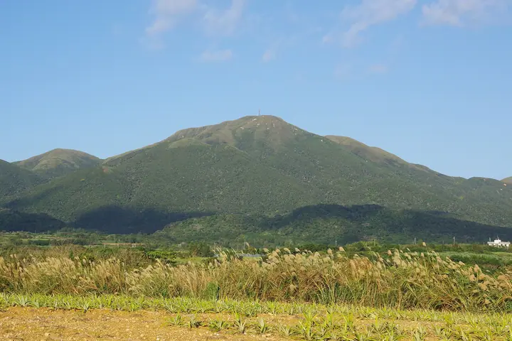
Mount Omotodake (526 m) is the highest peak in Okinawa Prefecture, standing in the centre of Ishigaki Island within Iriomote-Ishigaki National Park. Its Tertiary granite slopes carry subtropical evergreen broadleaf forest of itajii trees, while Ryukyu bamboo grass covers the summit. Considered an ancient sacred mountain of Yaeyama whose name "Umutu" means "great origin of the island," it is designated a National Place of Scenic Beauty together with Kabira Bay and also known as Ishigaki-Fuji. The peak is listed in the New Japan 100 Mountains and Prefecture High Points selections.
Mt. Omotodake at a glance
- Weather: The most settled day in the next 7 days is Wed, November 4: clear, gusts up to 7 m/s. Sat, Nov 7: strong wind (gusts up to 18 m/s).
- Route: The shortest is Mount Omoto Return Route, Ishigaki Island: about 2 h 56 min, 5.1 km, about 390 m of climbing.
Mt. Omotodake weather (hourly, 14 days)
Sunrise today 06:51, sunset 18:03
| Tue, 11/3 | Wed, 11/4 | Thu, 11/5 | Fri, 11/6 | Sat, 11/7 | Sun, 11/8 | Mon, 11/9 | Tue, 11/10 | Wed, 11/11 | Thu, 11/12 | Fri, 11/13 | Sat, 11/14 | Sun, 11/15 | Mon, 11/16 | Tue, 11/17 | |||||||||||||||||||||||||||||||||||||||||||||||||||||||||||||||||||||||
|---|---|---|---|---|---|---|---|---|---|---|---|---|---|---|---|---|---|---|---|---|---|---|---|---|---|---|---|---|---|---|---|---|---|---|---|---|---|---|---|---|---|---|---|---|---|---|---|---|---|---|---|---|---|---|---|---|---|---|---|---|---|---|---|---|---|---|---|---|---|---|---|---|---|---|---|---|---|---|---|---|---|---|---|---|---|
| Japan time | 15 | 17 | 19 | 21 | 23 | 1 | 3 | 5 | 7 | 9 | 11 | 13 | 15 | 18 | 21 | 0 | 3 | 6 | 9 | 12 | 15 | 18 | 21 | 0 | 3 | 6 | 9 | 12 | 15 | 18 | 21 | 0 | 3 | 6 | 9 | 12 | 15 | 18 | 21 | 0 | 3 | 6 | 9 | 12 | 15 | 18 | 21 | 0 | 3 | 6 | 9 | 15 | 21 | 3 | 9 | 15 | 21 | 3 | 9 | 15 | 21 | 3 | 9 | 15 | 21 | 3 | 9 | 15 | 21 | 3 | 9 | 15 | 21 | 3 | 9 | 15 | 21 | 3 | 9 | 15 | 21 | 3 | 9 | 15 | |
  | |   |   | | |   | |   |   | | | |  | |  | | | | | | | |   |   |   |   | | | | | | | |   | | | | | | | | |   | | | |   | | | | | | | | | | | | | | | | | | | | | | | | | | | | | | | | | | | | | ||
| Temperature | °C | 23° | 23° | 22° | 22° | 22° | 22° | 22° | 22° | 22° | 23° | 23° | 23° | 24° | 23° | 22° | 22° | 22° | 21° | 23° | 23° | 23° | 23° | 23° | 22° | 21° | 21° | 21° | 22° | 22° | 22° | 22° | 23° | 22° | 21° | 22° | 22° | 22° | 22° | 22° | 22° | 22° | 22° | 23° | 23° | 23° | 22° | 22° | 22° | 22° | 22° | 23° | 23° | 22° | 20° | 21° | 20° | 19° | 20° | 20° | 20° | 19° | 20° | 21° | 21° | 21° | 20° | 21° | 22° | 21° | 22° | 22° | 24° | 23° | 23° | 20° | 21° | 21° | 20° | 21° | 21° | 20° | 20° | 21° | 20° |
| Precipitation | mm | 0.2 | 0.9 | 1.6 | 0.5 | 0.3 | 0.6 | 0.6 | 0.2 | 0.3 | 0.1 | 0.1 | 0.1 | 1.0 | 2.3 | 1.6 | 0.4 | 0.2 | 0.2 | 0.1 | 0.5 | 0.4 | 0.3 | 0.2 | 9 | 7 | 4.3 | 11 | 2.7 | 8 | 16 | 13 | 1.3 | 3.0 | |||||||||||||||||||||||||||||||||||||||||||||||||||
| New snow | cm | ||||||||||||||||||||||||||||||||||||||||||||||||||||||||||||||||||||||||||||||||||||
| Snow depth | cm | 0 | 0 | 0 | 0 | 0 | 0 | 0 | 0 | 0 | 0 | 0 | 0 | 0 | 0 | 0 | 0 | 0 | 0 | 0 | 0 | 0 | 0 | 0 | 0 | 0 | 0 | 0 | 0 | 0 | 0 | 0 | 0 | 0 | 0 | 0 | 0 | 0 | 0 | 0 | 0 | 0 | 0 | 0 | 0 | 0 | 0 | 0 | 0 | 0 | 0 | 0 | 0 | 0 | 0 | 0 | 0 | 0 | 0 | 0 | 0 | 0 | 0 | 0 | 0 | 0 | 0 | 0 | 0 | 0 | 0 | 0 | 0 | 0 | 0 | 0 | 0 | 0 | 0 | 0 | 0 | 0 | 0 | 0 | 0 |
| Wind | m/s | 6 | 6 | 7 | 6 | 5 | 6 | 4 | 5 | 3 | 4 | 4 | 3 | 2 | 3 | 2 | 1 | 1 | 2 | 2 | 3 | 4 | 4 | 3 | 3 | 5 | 7 | 7 | 7 | 6 | 7 | 7 | 7 | 7 | 8 | 9 | 10 | 11 | 10 | 9 | 9 | 6 | 6 | 5 | 6 | 6 | 5 | 5 | 5 | 5 | 5 | 6 | 6 | 6 | 7 | 12 | 12 | 12 | 9 | 8 | 7 | 7 | 5 | 4 | 4 | 5 | 3 | 4 | 6 | 7 | 7 | 7 | 5 | 6 | 6 | 4 | 3 | 1 | 2 | 3 | 9 | 8 | 6 | 8 | 8 |
| Wind gusts | m/s | 10 | 10 | 11 | 11 | 10 | 9 | 9 | 8 | 7 | 7 | 7 | 7 | 5 | 5 | 5 | 3 | 2 | 3 | 4 | 5 | 7 | 7 | 6 | 5 | 7 | 10 | 11 | 11 | 11 | 11 | 11 | 11 | 11 | 12 | 14 | 17 | 18 | 18 | 15 | 15 | 14 | 10 | 10 | 10 | 10 | 10 | 9 | 9 | 8 | 8 | 10 | 11 | 11 | 11 | 19 | 20 | 19 | 18 | 15 | 13 | 12 | 11 | 9 | 8 | 9 | 9 | 7 | 11 | 11 | 12 | 11 | 11 | 9 | 10 | 11 | 9 | 7 | 5 | 5 | 13 | 14 | 12 | 12 | 14 |
| Wind dir. | ↓ | ↓ | ↓ | ↓ | ↓ | ↓ | ↓ | ↓ | ↓ | ↓ | ↓ | ↓ | ↓ | ↓ | ↓ | ↓ | ↓ | ↓ | ↓ | ↓ | ↓ | ↓ | ↓ | ↓ | ↓ | ↓ | ↓ | ↓ | ↓ | ↓ | ↓ | ↓ | ↓ | ↓ | ↓ | ↓ | ↓ | ↓ | ↓ | ↓ | ↓ | ↓ | ↓ | ↓ | ↓ | ↓ | ↓ | ↓ | ↓ | ↓ | ↓ | ↓ | ↓ | ↓ | ↓ | ↓ | ↓ | ↓ | ↓ | ↓ | ↓ | ↓ | ↓ | ↓ | ↓ | ↓ | ↓ | ↓ | ↓ | ↓ | ↓ | ↓ | ↓ | ↓ | ↓ | ↓ | ↓ | ↓ | ↓ | ↓ | ↓ | ↓ | ↓ | ↓ | |
Mt. Omotodake hiking routes
Hiking times are estimates calculated from the terrain.
Huts, campsites and lodging near Mt. Omotodake
Lodging
- Genius Resort石垣島川平
Lists that include Mt. Omotodake
New Japan 100 Famous Mountains · Highest Peaks by Prefecture · Elevations of 1003 Mountains of Japan
Mt. Omotodake facts
- Also known as
- 石垣富士
- Elevation
- 526 m
- Location
- Ishigaki, Okinawa
24.427243, 124.183424 - National Park
- 西表石垣国立公園
- Website
- www.city.ishigaki.okinawa.jp
- Wikipedia
- ja.wikipedia.org