
Mt. Noma
野間岳
Minamisatsuma, Kagoshima · Elevation 591 m
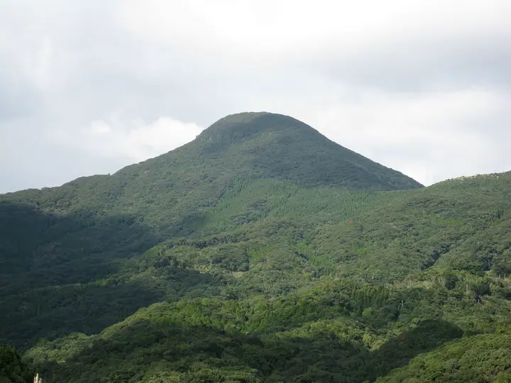
Mt. Noma is a 591-meter cone-shaped pyroxene-andesite volcano on the Noma Peninsula at the southwestern tip of the Satsuma Peninsula, in Kasasa Town of Minami-Satsuma City, Kagoshima Prefecture. The summit hosts the inner shrine of Noma Jinja, dedicated to maritime guardian deities, within Bo-Noma Prefectural Natural Park. Together with Mt. Kaimon and Mt. Kinpo it forms the "Three Famous Mountains of the Satsuma Peninsula" and is listed among Kyushu's 100 Famous Mountains.
Mt. Noma at a glance
- Weather: The most settled day in the next 7 days is Sun, November 8: clear, gusts up to 7 m/s. Fri, Nov 6: strong wind (gusts up to 16 m/s).
- Route: The shortest is Mount Noma, One of the Three Nansatsu Peaks, Summit Return from Noma Shrine at the Eighth Station: about 1 h 7 min, 1.4 km, about 240 m of climbing.
Mt. Noma weather (hourly, 14 days)
Sunrise today 06:36, sunset 17:30
| Tue, 11/3 | Wed, 11/4 | Thu, 11/5 | Fri, 11/6 | Sat, 11/7 | Sun, 11/8 | Mon, 11/9 | Tue, 11/10 | Wed, 11/11 | Thu, 11/12 | Fri, 11/13 | Sat, 11/14 | Sun, 11/15 | Mon, 11/16 | Tue, 11/17 | |||||||||||||||||||||||||||||||||||||||||||||||||||||||||||||||||||||||
|---|---|---|---|---|---|---|---|---|---|---|---|---|---|---|---|---|---|---|---|---|---|---|---|---|---|---|---|---|---|---|---|---|---|---|---|---|---|---|---|---|---|---|---|---|---|---|---|---|---|---|---|---|---|---|---|---|---|---|---|---|---|---|---|---|---|---|---|---|---|---|---|---|---|---|---|---|---|---|---|---|---|---|---|---|---|
| Japan time | 15 | 17 | 19 | 21 | 23 | 1 | 3 | 5 | 7 | 9 | 11 | 13 | 15 | 18 | 21 | 0 | 3 | 6 | 9 | 12 | 15 | 18 | 21 | 0 | 3 | 6 | 9 | 12 | 15 | 18 | 21 | 0 | 3 | 6 | 9 | 12 | 15 | 18 | 21 | 0 | 3 | 6 | 9 | 12 | 15 | 18 | 21 | 0 | 3 | 6 | 9 | 15 | 21 | 3 | 9 | 15 | 21 | 3 | 9 | 15 | 21 | 3 | 9 | 15 | 21 | 3 | 9 | 15 | 21 | 3 | 9 | 15 | 21 | 3 | 9 | 15 | 21 | 3 | 9 | 15 | 21 | 3 | 9 | 15 | |
 | |  |   | |   | | |   |   | | | | | | | |   | |   |   | | | | | | | | | |  | | | | | | | | | | | | | | | | | | | | | | |   | | | | | | | | | | | |  | | | | | | | | |   |   | | | | |  | | | | ||
| Temperature | °C | 17° | 17° | 17° | 16° | 16° | 16° | 15° | 15° | 15° | 16° | 17° | 18° | 20° | 18° | 17° | 16° | 17° | 16° | 18° | 19° | 20° | 19° | 19° | 19° | 18° | 17° | 16° | 17° | 17° | 17° | 15° | 14° | 13° | 11° | 10° | 11° | 12° | 13° | 12° | 11° | 10° | 11° | 13° | 15° | 15° | 15° | 15° | 14° | 15° | 15° | 14° | 15° | 15° | 13° | 12° | 14° | 13° | 13° | 11° | 12° | 12° | 11° | 12° | 13° | 13° | 12° | 12° | 15° | 14° | 13° | 14° | 18° | 16° | 16° | 17° | 18° | 18° | 17° | 16° | 16° | 15° | 14° | 13° | 15° |
| Precipitation | mm | 0.9 | 1.5 | 1.5 | 0.2 | 0.2 | 0.2 | 4.3 | 15 | 26 | 0.9 | ||||||||||||||||||||||||||||||||||||||||||||||||||||||||||||||||||||||||||
| New snow | cm | ||||||||||||||||||||||||||||||||||||||||||||||||||||||||||||||||||||||||||||||||||||
| Snow depth | cm | 0 | 0 | 0 | 0 | 0 | 0 | 0 | 0 | 0 | 0 | 0 | 0 | 0 | 0 | 0 | 0 | 0 | 0 | 0 | 0 | 0 | 0 | 0 | 0 | 0 | 0 | 0 | 0 | 0 | 0 | 0 | 0 | 0 | 0 | 0 | 0 | 0 | 0 | 0 | 0 | 0 | 0 | 0 | 0 | 0 | 0 | 0 | 0 | 0 | 0 | 0 | 0 | 0 | 0 | 0 | 0 | 0 | 0 | 0 | 0 | 0 | 0 | 0 | 0 | 0 | 0 | 0 | 0 | 0 | 0 | 0 | 0 | 0 | 0 | 0 | 0 | 0 | 0 | 0 | 0 | 0 | 0 | 0 | 0 |
| Wind | m/s | 6 | 6 | 7 | 5 | 3 | 4 | 5 | 6 | 5 | 6 | 6 | 4 | 4 | 6 | 4 | 4 | 5 | 4 | 4 | 5 | 6 | 6 | 8 | 8 | 10 | 10 | 10 | 10 | 11 | 11 | 11 | 10 | 10 | 10 | 9 | 9 | 9 | 8 | 5 | 3 | 4 | 4 | 4 | 3 | 4 | 4 | 3 | 3 | 4 | 6 | 6 | 8 | 7 | 8 | 9 | 11 | 11 | 7 | 8 | 8 | 6 | 5 | 5 | 7 | 6 | 6 | 3 | 4 | 3 | 5 | 5 | 5 | 6 | 6 | 7 | 8 | 8 | 9 | 7 | 9 | 7 | 4 | 2 | 4 |
| Wind gusts | m/s | 9 | 9 | 10 | 10 | 7 | 6 | 8 | 8 | 9 | 8 | 8 | 8 | 6 | 8 | 8 | 7 | 7 | 8 | 6 | 7 | 9 | 10 | 11 | 11 | 14 | 14 | 14 | 14 | 16 | 16 | 15 | 15 | 15 | 14 | 14 | 13 | 13 | 13 | 12 | 8 | 6 | 7 | 7 | 6 | 6 | 6 | 6 | 5 | 6 | 9 | 9 | 12 | 11 | 12 | 13 | 15 | 16 | 15 | 12 | 12 | 11 | 9 | 9 | 10 | 10 | 9 | 9 | 6 | 6 | 8 | 9 | 8 | 9 | 9 | 10 | 12 | 12 | 12 | 12 | 13 | 13 | 10 | 6 | 6 |
| Wind dir. | ↓ | ↓ | ↓ | ↓ | ↓ | ↓ | ↓ | ↓ | ↓ | ↓ | ↓ | ↓ | ↓ | ↓ | ↓ | ↓ | ↓ | ↓ | ↓ | ↓ | ↓ | ↓ | ↓ | ↓ | ↓ | ↓ | ↓ | ↓ | ↓ | ↓ | ↓ | ↓ | ↓ | ↓ | ↓ | ↓ | ↓ | ↓ | ↓ | ↓ | ↓ | ↓ | ↓ | ↓ | ↓ | ↓ | ↓ | ↓ | ↓ | ↓ | ↓ | ↓ | ↓ | ↓ | ↓ | ↓ | ↓ | ↓ | ↓ | ↓ | ↓ | ↓ | ↓ | ↓ | ↓ | ↓ | ↓ | ↓ | ↓ | ↓ | ↓ | ↓ | ↓ | ↓ | ↓ | ↓ | ↓ | ↓ | ↓ | ↓ | ↓ | ↓ | ↓ | ↓ | |
Mt. Noma hiking routes
Hiking times are estimates calculated from the terrain.
Huts, campsites and lodging near Mt. Noma
Lodging
- 笠沙恵比寿
Lists that include Mt. Noma
Kyushu 100 Famous Mountains · Elevations of 1003 Mountains of Japan · 1000 Mountains of Japan
Mt. Noma facts
- Also known as
- 笠沙岳 · 野馬岳
- Elevation
- 591 m
- Location
- Minamisatsuma, Kagoshima
31.404560, 130.158210 - Website
- kanko-minamisatsuma.jp
- Wikipedia
- ja.wikipedia.org