
Mt. Muronesan
室根山
Ichinoseki, Iwate · Elevation 895 m
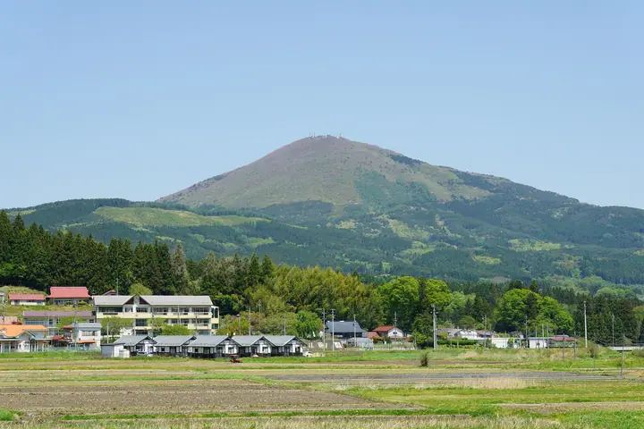
Muronesan is a 895.4 m solitary peak in the Murone district of Ichinoseki City, Iwate Prefecture. Its conical profile has earned it the nickname 'Oku-no-Fuji,' and the mountain appears in the Nihon Hyaku-Fuji list of regional Fujis. The slopes are designated as Murone-Kōgen Prefectural Natural Park and shelter Murone-jinja, an ancient shrine linked to the Mutsu Province first shrine, near the eighth station. Around 200,000 wild azaleas bloom from late May into mid-June, drawing crowds to the Murone Tsutsuji Festival, while the summit observation deck commands a 360-degree panorama from the Pacific Ocean across Mt. Hayachine and as far as distant Kinkasan. The peak is included in the Iwate Hyakumeizan, Nihon-no-Yama 1000, the Iwate prefectural climbing guide and other regional lists.
Mt. Muronesan at a glance
- Weather: The most settled day in the next 7 days is Wed, November 4: clear, gusts up to 9 m/s. Fri, Nov 6, Sat, Nov 7, Sun, Nov 8: strong wind (gusts up to 20 m/s).
- Route: The shortest is Mount Murone Round Trip from Murone Shrine Approach: about 2 h 41 min, 3.8 km, about 520 m of climbing.
Mt. Muronesan weather (hourly, 14 days)
Sunrise today 06:03, sunset 16:33
| Tue, 11/3 | Wed, 11/4 | Thu, 11/5 | Fri, 11/6 | Sat, 11/7 | Sun, 11/8 | Mon, 11/9 | Tue, 11/10 | Wed, 11/11 | Thu, 11/12 | Fri, 11/13 | Sat, 11/14 | Sun, 11/15 | Mon, 11/16 | Tue, 11/17 | |||||||||||||||||||||||||||||||||||||||||||||||||||||||||||||||||||||||
|---|---|---|---|---|---|---|---|---|---|---|---|---|---|---|---|---|---|---|---|---|---|---|---|---|---|---|---|---|---|---|---|---|---|---|---|---|---|---|---|---|---|---|---|---|---|---|---|---|---|---|---|---|---|---|---|---|---|---|---|---|---|---|---|---|---|---|---|---|---|---|---|---|---|---|---|---|---|---|---|---|---|---|---|---|---|
| Japan time | 15 | 17 | 19 | 21 | 23 | 1 | 3 | 5 | 7 | 9 | 11 | 13 | 15 | 18 | 21 | 0 | 3 | 6 | 9 | 12 | 15 | 18 | 21 | 0 | 3 | 6 | 9 | 12 | 15 | 18 | 21 | 0 | 3 | 6 | 9 | 12 | 15 | 18 | 21 | 0 | 3 | 6 | 9 | 12 | 15 | 18 | 21 | 0 | 3 | 6 | 9 | 15 | 21 | 3 | 9 | 15 | 21 | 3 | 9 | 15 | 21 | 3 | 9 | 15 | 21 | 3 | 9 | 15 | 21 | 3 | 9 | 15 | 21 | 3 | 9 | 15 | 21 | 3 | 9 | 15 | 21 | 3 | 9 | 15 | |
 |  | | | | | | | | |   |   | |   | | |   | |   | | | |   | |   |   | |   | | | | | | |   | | | | | | |   | | | | | | | | | | |   | | | | | | | | | | | |  | | | | | | | | | | | | | | | | | | | | ||
| Temperature | °C | 8° | 4° | 2° | 0° | -1° | -2° | -2° | -2° | 1° | 8° | 10° | 11° | 11° | 5° | 4° | 5° | 6° | 6° | 8° | 9° | 9° | 9° | 9° | 9° | 7° | 6° | 11° | 14° | 14° | 9° | 7° | 4° | 2° | 1° | 3° | 3° | 2° | 0° | 0° | 0° | 0° | 0° | 3° | 5° | 3° | 1° | -1° | -1° | -1° | -2° | 3° | 4° | -2° | -3° | 3° | 3° | 4° | 2° | 3° | 4° | 0° | -3° | 3° | 6° | -1° | 1° | 3° | 3° | -2° | -5° | 2° | 6° | -2° | -3° | 6° | 9° | 4° | 5° | 8° | 8° | 0° | -2° | 2° | 5° |
| Precipitation | mm | 0.1 | 2.8 | 7 | 4.5 | 4.9 | 1.3 | 1.1 | 1.0 | 0.5 | 0.1 | 0.1 | 0.8 | 0.7 | 0.2 | 0.2 | 0.1 | 0.1 | 0.2 | 7 | 2.2 | 1.0 | 1.5 | 0.5 | 0.4 | 4.5 | 1.3 | 0.2 | |||||||||||||||||||||||||||||||||||||||||||||||||||||||||
| New snow | cm | ||||||||||||||||||||||||||||||||||||||||||||||||||||||||||||||||||||||||||||||||||||
| Snow depth | cm | 0 | 0 | 0 | 0 | 0 | 0 | 0 | 0 | 0 | 0 | 0 | 0 | 0 | 0 | 0 | 0 | 0 | 0 | 0 | 0 | 0 | 0 | 0 | 0 | 0 | 0 | 0 | 0 | 0 | 0 | 0 | 0 | 0 | 0 | 0 | 0 | 0 | 0 | 0 | 0 | 0 | 0 | 0 | 0 | 0 | 0 | 0 | 0 | 0 | 0 | 0 | 0 | 0 | 0 | 0 | 0 | 0 | 0 | 0 | 0 | 0 | 0 | 0 | 0 | 0 | 0 | 0 | 0 | 0 | 0 | 0 | 0 | 0 | 0 | 0 | 0 | 0 | 0 | 0 | 0 | 0 | 0 | 0 | 0 |
| Wind | m/s | 5 | 3 | 2 | 1 | 1 | 1 | 1 | 2 | 2 | 2 | 3 | 2 | 1 | 1 | 1 | 1 | 1 | 1 | 1 | 2 | 2 | 1 | 0 | 0 | 1 | 1 | 1 | 6 | 7 | 5 | 6 | 6 | 5 | 6 | 6 | 6 | 6 | 6 | 6 | 6 | 7 | 6 | 7 | 8 | 8 | 5 | 1 | 1 | 1 | 1 | 1 | 4 | 2 | 3 | 2 | 4 | 4 | 0 | 6 | 7 | 3 | 2 | 2 | 4 | 1 | 1 | 5 | 6 | 3 | 2 | 1 | 1 | 0 | 1 | 1 | 1 | 1 | 0 | 2 | 6 | 6 | 5 | 2 | 3 |
| Wind gusts | m/s | 14 | 11 | 6 | 5 | 4 | 4 | 4 | 4 | 5 | 6 | 9 | 8 | 6 | 4 | 3 | 4 | 5 | 4 | 4 | 5 | 6 | 5 | 3 | 2 | 3 | 3 | 5 | 13 | 16 | 17 | 13 | 15 | 13 | 14 | 14 | 17 | 16 | 14 | 14 | 15 | 16 | 16 | 16 | 19 | 20 | 17 | 11 | 4 | 4 | 3 | 4 | 10 | 8 | 6 | 6 | 11 | 10 | 9 | 16 | 19 | 15 | 7 | 5 | 11 | 8 | 4 | 12 | 14 | 13 | 7 | 5 | 8 | 3 | 3 | 4 | 6 | 4 | 4 | 5 | 13 | 18 | 14 | 12 | 9 |
| Wind dir. | ↓ | ↓ | ↓ | ↓ | ↓ | ↓ | ↓ | ↓ | ↓ | ↓ | ↓ | ↓ | ↓ | ↓ | ↓ | ↓ | ↓ | ↓ | ↓ | ↓ | ↓ | ↓ | ↓ | ↓ | ↓ | ↓ | ↓ | ↓ | ↓ | ↓ | ↓ | ↓ | ↓ | ↓ | ↓ | ↓ | ↓ | ↓ | ↓ | ↓ | ↓ | ↓ | ↓ | ↓ | ↓ | ↓ | ↓ | ↓ | ↓ | ↓ | ↓ | ↓ | ↓ | ↓ | ↓ | ↓ | ↓ | ↓ | ↓ | ↓ | ↓ | ↓ | ↓ | ↓ | ↓ | ↓ | ↓ | ↓ | ↓ | ↓ | ↓ | ↓ | ↓ | ↓ | ↓ | ↓ | ↓ | ↓ | ↓ | ↓ | ↓ | ↓ | ↓ | ↓ | |
Mt. Muronesan hiking routes
Hiking times are estimates calculated from the terrain.
Huts, campsites and lodging near Mt. Muronesan
Campsites
- 望洋平キャンプ場
- 望洋平オートキャンプ場
- 飛ヶ森キャンプ場
Lists that include Mt. Muronesan
100 Fujis of Japan · Iwate 100 Famous Mountains · Elevations of 1003 Mountains of Japan · 1000 Mountains of Japan
Mt. Muronesan facts
- Also known as
- 奥の富士 · 桔梗山 · 卯辰山
- Elevation
- 895 m
- Location
- Ichinoseki, Iwate
38.975154, 141.447263 - Website
- www.ichitabi.jp
- Wikipedia
- ja.wikipedia.org