
Mt. Kōnomine
鴻ノ峰
Yamaguchi, Yamaguchi · Elevation 338 m
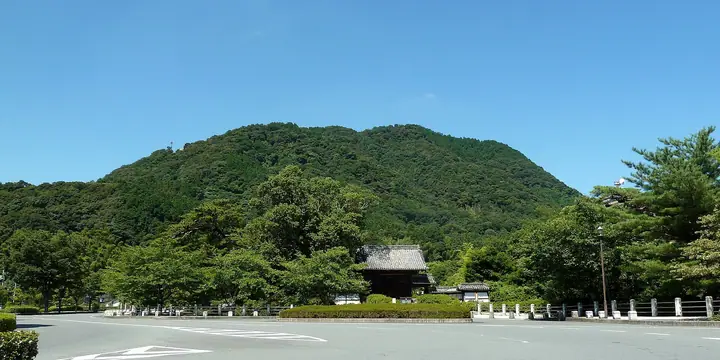
A 338 m hill in the Kami-Unorei district of Yamaguchi City, Yamaguchi Prefecture, looking down on the prefectural capital from the west. The summit retains the ruins of Takamine Castle, built in 1557 by the last lord of the Ōuchi clan, Ōuchi Yoshinaga, as a defensive stronghold against the advancing Mōri — its massive stone walls and well-shaft are preserved as part of the nationally designated "Ōuchi-shi Iseki" historic site. Several short trails leave from Yamaguchi-Daijingū Shrine, Kido Shrine and the surrounding parks, and the peak is included in the "Yamaguchi 100 Mountains", "Bōchō Hyakuzan", "Suō 100 Mountain Views" and "Yamaguchi-ken no Yama" hiking guides.
Mt. Kōnomine at a glance
- Weather: The most settled day in the next 7 days is Sun, November 8: clear, gusts up to 5 m/s.
Mt. Kōnomine weather (hourly, 14 days)
Sunrise today 06:35, sunset 17:21
| Tue, 11/3 | Wed, 11/4 | Thu, 11/5 | Fri, 11/6 | Sat, 11/7 | Sun, 11/8 | Mon, 11/9 | Tue, 11/10 | Wed, 11/11 | Thu, 11/12 | Fri, 11/13 | Sat, 11/14 | Sun, 11/15 | Mon, 11/16 | Tue, 11/17 | |||||||||||||||||||||||||||||||||||||||||||||||||||||||||||||||||||||||
|---|---|---|---|---|---|---|---|---|---|---|---|---|---|---|---|---|---|---|---|---|---|---|---|---|---|---|---|---|---|---|---|---|---|---|---|---|---|---|---|---|---|---|---|---|---|---|---|---|---|---|---|---|---|---|---|---|---|---|---|---|---|---|---|---|---|---|---|---|---|---|---|---|---|---|---|---|---|---|---|---|---|---|---|---|---|
| Japan time | 15 | 17 | 19 | 21 | 23 | 1 | 3 | 5 | 7 | 9 | 11 | 13 | 15 | 18 | 21 | 0 | 3 | 6 | 9 | 12 | 15 | 18 | 21 | 0 | 3 | 6 | 9 | 12 | 15 | 18 | 21 | 0 | 3 | 6 | 9 | 12 | 15 | 18 | 21 | 0 | 3 | 6 | 9 | 12 | 15 | 18 | 21 | 0 | 3 | 6 | 9 | 15 | 21 | 3 | 9 | 15 | 21 | 3 | 9 | 15 | 21 | 3 | 9 | 15 | 21 | 3 | 9 | 15 | 21 | 3 | 9 | 15 | 21 | 3 | 9 | 15 | 21 | 3 | 9 | 15 | 21 | 3 | 9 | 15 | |
  | |   | | | |   | | | | |   | | |   | | | | |   | |   | | |  | |  | | | | | | | | | | | | | | | | | | | | | | | | |   |   |   | | | | |   | | |  | | | |   | | | | | | | | |   | | | | | | | | | | ||
| Temperature | °C | 16° | 14° | 12° | 11° | 11° | 11° | 10° | 11° | 10° | 14° | 17° | 17° | 17° | 14° | 13° | 13° | 12° | 12° | 15° | 16° | 17° | 15° | 15° | 14° | 13° | 12° | 15° | 16° | 13° | 10° | 9° | 8° | 7° | 7° | 10° | 12° | 12° | 7° | 5° | 4° | 4° | 4° | 10° | 13° | 14° | 11° | 10° | 8° | 9° | 10° | 13° | 14° | 8° | 7° | 12° | 13° | 11° | 8° | 10° | 12° | 6° | 3° | 10° | 14° | 7° | 6° | 12° | 14° | 7° | 4° | 10° | 15° | 10° | 12° | 13° | 15° | 14° | 13° | 14° | 15° | 10° | 8° | 10° | 13° |
| Precipitation | mm | 0.2 | 0.9 | 0.4 | 2.9 | 0.5 | 0.7 | 0.1 | 0.2 | 1.8 | 24 | 14 | 0.3 | 0.4 | 0.1 | ||||||||||||||||||||||||||||||||||||||||||||||||||||||||||||||||||||||
| New snow | cm | ||||||||||||||||||||||||||||||||||||||||||||||||||||||||||||||||||||||||||||||||||||
| Snow depth | cm | 0 | 0 | 0 | 0 | 0 | 0 | 0 | 0 | 0 | 0 | 0 | 0 | 0 | 0 | 0 | 0 | 0 | 0 | 0 | 0 | 0 | 0 | 0 | 0 | 0 | 0 | 0 | 0 | 0 | 0 | 0 | 0 | 0 | 0 | 0 | 0 | 0 | 0 | 0 | 0 | 0 | 0 | 0 | 0 | 0 | 0 | 0 | 0 | 0 | 0 | 0 | 0 | 0 | 0 | 0 | 0 | 0 | 0 | 0 | 0 | 0 | 0 | 0 | 0 | 0 | 0 | 0 | 0 | 0 | 0 | 0 | 0 | 0 | 0 | 0 | 0 | 0 | 0 | 0 | 0 | 0 | 0 | 0 | 0 |
| Wind | m/s | 4 | 3 | 3 | 3 | 3 | 4 | 4 | 3 | 2 | 1 | 2 | 2 | 2 | 1 | 2 | 0 | 2 | 1 | 1 | 2 | 4 | 3 | 1 | 5 | 5 | 4 | 6 | 6 | 6 | 4 | 5 | 5 | 4 | 4 | 4 | 4 | 4 | 2 | 1 | 2 | 2 | 2 | 1 | 1 | 0 | 0 | 0 | 1 | 2 | 2 | 3 | 4 | 2 | 2 | 3 | 5 | 4 | 5 | 3 | 4 | 1 | 1 | 0 | 4 | 1 | 1 | 1 | 4 | 3 | 1 | 1 | 2 | 2 | 4 | 5 | 5 | 1 | 4 | 4 | 5 | 5 | 3 | 1 | 3 |
| Wind gusts | m/s | 10 | 10 | 8 | 8 | 8 | 8 | 8 | 8 | 7 | 4 | 7 | 6 | 6 | 5 | 6 | 4 | 4 | 4 | 4 | 6 | 11 | 10 | 6 | 10 | 11 | 10 | 13 | 15 | 15 | 13 | 10 | 11 | 11 | 10 | 10 | 11 | 11 | 9 | 5 | 4 | 5 | 5 | 5 | 4 | 4 | 3 | 2 | 3 | 4 | 7 | 6 | 10 | 10 | 6 | 7 | 12 | 12 | 12 | 11 | 10 | 9 | 3 | 3 | 9 | 9 | 3 | 4 | 9 | 9 | 6 | 4 | 7 | 6 | 8 | 12 | 12 | 11 | 9 | 9 | 13 | 12 | 11 | 7 | 8 |
| Wind dir. | ↓ | ↓ | ↓ | ↓ | ↓ | ↓ | ↓ | ↓ | ↓ | ↓ | ↓ | ↓ | ↓ | ↓ | ↓ | ↓ | ↓ | ↓ | ↓ | ↓ | ↓ | ↓ | ↓ | ↓ | ↓ | ↓ | ↓ | ↓ | ↓ | ↓ | ↓ | ↓ | ↓ | ↓ | ↓ | ↓ | ↓ | ↓ | ↓ | ↓ | ↓ | ↓ | ↓ | ↓ | ↓ | ↓ | ↓ | ↓ | ↓ | ↓ | ↓ | ↓ | ↓ | ↓ | ↓ | ↓ | ↓ | ↓ | ↓ | ↓ | ↓ | ↓ | ↓ | ↓ | ↓ | ↓ | ↓ | ↓ | ↓ | ↓ | ↓ | ↓ | ↓ | ↓ | ↓ | ↓ | ↓ | ↓ | ↓ | ↓ | ↓ | ↓ | ↓ | ↓ | |
Huts, campsites and lodging near Mt. Kōnomine
Lodging
- サンルート国際ホテル山口
- KKR Yamaguchi Asakura
- 防長苑
- セントコア山口
- 翠山荘
Lists that include Mt. Kōnomine
Mt. Kōnomine facts
- Elevation
- 338 m
- Location
- Yamaguchi, Yamaguchi
34.185163, 131.462048 - Website
- www.city.yamaguchi.lg.jp
- Access Information
- yamaguchi-tourism.jp
- Wikipedia
- ja.wikipedia.org