
Mt. Komidake
古見岳
Taketomi, Okinawa · Elevation 470 m
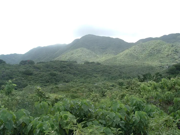
A 469.5-meter peak rising in the heart of Iriomote Island in Taketomi Town, Yaeyama District, Okinawa Prefecture — the highest summit on Iriomote and the fourth highest in Okinawa. A sacred peak known locally as "Kundagi," its approach is a demanding route of repeated river crossings and steep climbs through subtropical forest. The mountain lies within Iriomote-Ishigaki National Park as part of the World Natural Heritage area, and entry requires advance approval from the Taketomi Town mayor under the local controlled-access scheme.
Mt. Komidake at a glance
- Weather: The most settled day in the next 7 days is Thu, November 5: clear, gusts up to 8 m/s. Sat, Nov 7: strong wind (gusts up to 21 m/s).
Mt. Komidake weather (hourly, 14 days)
Sunrise today 06:52, sunset 18:04
| Tue, 11/3 | Wed, 11/4 | Thu, 11/5 | Fri, 11/6 | Sat, 11/7 | Sun, 11/8 | Mon, 11/9 | Tue, 11/10 | Wed, 11/11 | Thu, 11/12 | Fri, 11/13 | Sat, 11/14 | Sun, 11/15 | Mon, 11/16 | Tue, 11/17 | |||||||||||||||||||||||||||||||||||||||||||||||||||||||||||||||||||||||
|---|---|---|---|---|---|---|---|---|---|---|---|---|---|---|---|---|---|---|---|---|---|---|---|---|---|---|---|---|---|---|---|---|---|---|---|---|---|---|---|---|---|---|---|---|---|---|---|---|---|---|---|---|---|---|---|---|---|---|---|---|---|---|---|---|---|---|---|---|---|---|---|---|---|---|---|---|---|---|---|---|---|---|---|---|---|
| Japan time | 15 | 17 | 19 | 21 | 23 | 1 | 3 | 5 | 7 | 9 | 11 | 13 | 15 | 18 | 21 | 0 | 3 | 6 | 9 | 12 | 15 | 18 | 21 | 0 | 3 | 6 | 9 | 12 | 15 | 18 | 21 | 0 | 3 | 6 | 9 | 12 | 15 | 18 | 21 | 0 | 3 | 6 | 9 | 12 | 15 | 18 | 21 | 0 | 3 | 6 | 9 | 15 | 21 | 3 | 9 | 15 | 21 | 3 | 9 | 15 | 21 | 3 | 9 | 15 | 21 | 3 | 9 | 15 | 21 | 3 | 9 | 15 | 21 | 3 | 9 | 15 | 21 | 3 | 9 | 15 | 21 | 3 | 9 | 15 | |
  |   |   | |  |   | |   |  |   | | | | |  | | | | | | | | | |   | |   | | | | | | |   |   | | | | | | | | |   | | | |   | | | | | | | | | | | | | |   | | | |  | | | | | | | | | | | | | | | | | | | ||
| Temperature | °C | 24° | 23° | 22° | 23° | 22° | 22° | 22° | 22° | 22° | 24° | 25° | 25° | 25° | 22° | 21° | 21° | 21° | 21° | 24° | 26° | 25° | 23° | 23° | 22° | 21° | 21° | 21° | 23° | 23° | 22° | 23° | 23° | 22° | 21° | 22° | 23° | 23° | 23° | 22° | 22° | 22° | 22° | 23° | 24° | 24° | 22° | 22° | 23° | 22° | 22° | 24° | 24° | 23° | 19° | 20° | 20° | 19° | 20° | 20° | 21° | 20° | 19° | 21° | 23° | 21° | 20° | 22° | 23° | 21° | 22° | 23° | 24° | 22° | 23° | 21° | 22° | 21° | 20° | 21° | 21° | 20° | 20° | 21° | 21° |
| Precipitation | mm | 0.7 | 3.0 | 1.3 | 0.7 | 0.7 | 1.0 | 0.4 | 0.4 | 0.8 | 0.4 | 1.7 | 4.9 | 1.9 | 0.8 | 0.3 | 0.1 | 0.2 | 0.4 | 0.3 | 0.2 | 1.2 | 0.6 | 0.3 | 7 | 7 | 4.3 | 15 | 3.0 | 11 | 22 | 21 | 1.4 | 2.6 | |||||||||||||||||||||||||||||||||||||||||||||||||||
| New snow | cm | ||||||||||||||||||||||||||||||||||||||||||||||||||||||||||||||||||||||||||||||||||||
| Snow depth | cm | 0 | 0 | 0 | 0 | 0 | 0 | 0 | 0 | 0 | 0 | 0 | 0 | 0 | 0 | 0 | 0 | 0 | 0 | 0 | 0 | 0 | 0 | 0 | 0 | 0 | 0 | 0 | 0 | 0 | 0 | 0 | 0 | 0 | 0 | 0 | 0 | 0 | 0 | 0 | 0 | 0 | 0 | 0 | 0 | 0 | 0 | 0 | 0 | 0 | 0 | 0 | 0 | 0 | 0 | 0 | 0 | 0 | 0 | 0 | 0 | 0 | 0 | 0 | 0 | 0 | 0 | 0 | 0 | 0 | 0 | 0 | 0 | 0 | 0 | 0 | 0 | 0 | 0 | 0 | 0 | 0 | 0 | 0 | 0 |
| Wind | m/s | 5 | 5 | 5 | 5 | 5 | 3 | 4 | 3 | 3 | 3 | 3 | 3 | 3 | 1 | 1 | 1 | 1 | 1 | 1 | 2 | 3 | 3 | 3 | 2 | 3 | 5 | 6 | 5 | 5 | 6 | 6 | 6 | 6 | 6 | 7 | 8 | 9 | 8 | 7 | 7 | 5 | 4 | 4 | 4 | 5 | 4 | 4 | 4 | 4 | 4 | 5 | 5 | 5 | 7 | 9 | 9 | 10 | 7 | 7 | 6 | 5 | 4 | 4 | 3 | 3 | 3 | 3 | 5 | 6 | 6 | 6 | 4 | 4 | 5 | 4 | 3 | 1 | 2 | 2 | 7 | 6 | 5 | 6 | 7 |
| Wind gusts | m/s | 13 | 13 | 12 | 12 | 12 | 10 | 9 | 8 | 7 | 8 | 9 | 8 | 8 | 7 | 3 | 3 | 2 | 2 | 4 | 7 | 8 | 8 | 7 | 6 | 7 | 11 | 12 | 13 | 13 | 14 | 13 | 13 | 13 | 14 | 16 | 19 | 21 | 21 | 18 | 16 | 15 | 11 | 10 | 11 | 11 | 12 | 9 | 9 | 9 | 9 | 13 | 14 | 13 | 14 | 21 | 23 | 22 | 21 | 18 | 16 | 14 | 11 | 9 | 9 | 9 | 9 | 7 | 12 | 12 | 13 | 12 | 13 | 10 | 12 | 12 | 9 | 7 | 6 | 6 | 15 | 16 | 12 | 13 | 17 |
| Wind dir. | ↓ | ↓ | ↓ | ↓ | ↓ | ↓ | ↓ | ↓ | ↓ | ↓ | ↓ | ↓ | ↓ | ↓ | ↓ | ↓ | ↓ | ↓ | ↓ | ↓ | ↓ | ↓ | ↓ | ↓ | ↓ | ↓ | ↓ | ↓ | ↓ | ↓ | ↓ | ↓ | ↓ | ↓ | ↓ | ↓ | ↓ | ↓ | ↓ | ↓ | ↓ | ↓ | ↓ | ↓ | ↓ | ↓ | ↓ | ↓ | ↓ | ↓ | ↓ | ↓ | ↓ | ↓ | ↓ | ↓ | ↓ | ↓ | ↓ | ↓ | ↓ | ↓ | ↓ | ↓ | ↓ | ↓ | ↓ | ↓ | ↓ | ↓ | ↓ | ↓ | ↓ | ↓ | ↓ | ↓ | ↓ | ↓ | ↓ | ↓ | ↓ | ↓ | ↓ | ↓ | |
Huts, campsites and lodging near Mt. Komidake
Lodging
- Iriomotejima Jungle Hotel Painu Maya
- Eco Village
Lists that include Mt. Komidake
Mt. Komidake facts
- Also known as
- クンダギ
- Elevation
- 470 m
- Location
- Taketomi, Okinawa
24.359275, 123.891170 - National Park
- 西表石垣国立公園
- Website
- iriomote-ecotourism.jp
- Trail Map
- iriomote-ecotourism.jp (PDF)
- Wikipedia
- ja.wikipedia.org