
Mt. Kokuzo
虚空蔵山
Kawatana, Nagasaki / Ureshino, Saga · Elevation 608 m
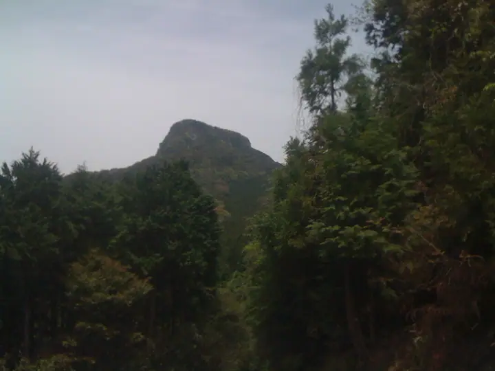
A 608.5-meter peak rising at the meeting point of Kawatana Town and Higashisonogi Town in Nagasaki Prefecture and Ureshino City in Saga Prefecture, nicknamed the "Matterhorn of Kyushu" for its sharp, conical profile. The summit holds a first-class triangulation point and a small shrine to Kokuzo Bosatsu, from which the mountain takes its name, and the peak is recognizable from JR Omura Line trains near Kawatana Station. Three trailheads—Iwaya and Koba on the Kawatana side and Saraya-dani on the Ureshino side—lead to the summit in 30–40 minutes. It is included in the Kyushu Hyakumeizan and several other prominent mountain lists.
Mt. Kokuzo at a glance
- Weather: The most settled day in the next 7 days is Wed, November 4: clear, gusts up to 9 m/s.
- Route: The shortest is Mount Kokūzō Koba Adventure and Family Loop: about 1 h 17 min, 1.7 km, about 260 m of climbing.
Mt. Kokuzo weather (hourly, 14 days)
Sunrise today 06:40, sunset 17:28
| Tue, 11/3 | Wed, 11/4 | Thu, 11/5 | Fri, 11/6 | Sat, 11/7 | Sun, 11/8 | Mon, 11/9 | Tue, 11/10 | Wed, 11/11 | Thu, 11/12 | Fri, 11/13 | Sat, 11/14 | Sun, 11/15 | Mon, 11/16 | Tue, 11/17 | |||||||||||||||||||||||||||||||||||||||||||||||||||||||||||||||||||||||
|---|---|---|---|---|---|---|---|---|---|---|---|---|---|---|---|---|---|---|---|---|---|---|---|---|---|---|---|---|---|---|---|---|---|---|---|---|---|---|---|---|---|---|---|---|---|---|---|---|---|---|---|---|---|---|---|---|---|---|---|---|---|---|---|---|---|---|---|---|---|---|---|---|---|---|---|---|---|---|---|---|---|---|---|---|---|
| Japan time | 15 | 17 | 19 | 21 | 23 | 1 | 3 | 5 | 7 | 9 | 11 | 13 | 15 | 18 | 21 | 0 | 3 | 6 | 9 | 12 | 15 | 18 | 21 | 0 | 3 | 6 | 9 | 12 | 15 | 18 | 21 | 0 | 3 | 6 | 9 | 12 | 15 | 18 | 21 | 0 | 3 | 6 | 9 | 12 | 15 | 18 | 21 | 0 | 3 | 6 | 9 | 15 | 21 | 3 | 9 | 15 | 21 | 3 | 9 | 15 | 21 | 3 | 9 | 15 | 21 | 3 | 9 | 15 | 21 | 3 | 9 | 15 | 21 | 3 | 9 | 15 | 21 | 3 | 9 | 15 | 21 | 3 | 9 | 15 | |
  |   |   |   | | | | | |  |   | | | | |   | |   |   |   | | | | | |  | |   | | | | | | | | | | | | | | | | | | | | | | | | |   | | | | | | | | | | | |  | | | | | | | | |   | | | | | | |  | | | | ||
| Temperature | °C | 15° | 13° | 12° | 12° | 11° | 11° | 11° | 11° | 11° | 13° | 15° | 16° | 17° | 14° | 13° | 13° | 12° | 12° | 15° | 16° | 17° | 16° | 14° | 14° | 13° | 11° | 14° | 16° | 13° | 10° | 9° | 8° | 6° | 6° | 8° | 10° | 10° | 7° | 5° | 4° | 4° | 5° | 9° | 11° | 11° | 10° | 9° | 9° | 9° | 9° | 12° | 14° | 8° | 7° | 10° | 11° | 8° | 7° | 9° | 11° | 6° | 5° | 9° | 13° | 7° | 5° | 10° | 15° | 9° | 7° | 10° | 16° | 11° | 13° | 14° | 15° | 13° | 13° | 13° | 15° | 10° | 8° | 10° | 14° |
| Precipitation | mm | 0.7 | 0.6 | 0.2 | 0.4 | 3.8 | 7 | 0.5 | 0.1 | 0.1 | 2.1 | 14 | 2.7 | ||||||||||||||||||||||||||||||||||||||||||||||||||||||||||||||||||||||||
| New snow | cm | ||||||||||||||||||||||||||||||||||||||||||||||||||||||||||||||||||||||||||||||||||||
| Snow depth | cm | 0 | 0 | 0 | 0 | 0 | 0 | 0 | 0 | 0 | 0 | 0 | 0 | 0 | 0 | 0 | 0 | 0 | 0 | 0 | 0 | 0 | 0 | 0 | 0 | 0 | 0 | 0 | 0 | 0 | 0 | 0 | 0 | 0 | 0 | 0 | 0 | 0 | 0 | 0 | 0 | 0 | 0 | 0 | 0 | 0 | 0 | 0 | 0 | 0 | 0 | 0 | 0 | 0 | 0 | 0 | 0 | 0 | 0 | 0 | 0 | 0 | 0 | 0 | 0 | 0 | 0 | 0 | 0 | 0 | 0 | 0 | 0 | 0 | 0 | 0 | 0 | 0 | 0 | 0 | 0 | 0 | 0 | 0 | 0 |
| Wind | m/s | 4 | 4 | 3 | 3 | 3 | 3 | 4 | 4 | 4 | 4 | 2 | 1 | 1 | 1 | 2 | 2 | 1 | 1 | 2 | 5 | 4 | 4 | 2 | 3 | 4 | 3 | 3 | 5 | 5 | 4 | 3 | 4 | 5 | 5 | 5 | 5 | 4 | 3 | 2 | 1 | 2 | 2 | 2 | 2 | 2 | 1 | 1 | 0 | 1 | 1 | 3 | 4 | 1 | 1 | 4 | 5 | 2 | 4 | 3 | 4 | 0 | 1 | 1 | 2 | 1 | 1 | 1 | 3 | 3 | 2 | 1 | 2 | 2 | 4 | 6 | 4 | 1 | 3 | 4 | 5 | 3 | 4 | 5 | 4 |
| Wind gusts | m/s | 10 | 10 | 8 | 7 | 7 | 8 | 8 | 8 | 9 | 8 | 9 | 6 | 4 | 3 | 5 | 4 | 4 | 4 | 6 | 11 | 10 | 10 | 9 | 7 | 8 | 8 | 8 | 12 | 12 | 11 | 8 | 9 | 10 | 10 | 12 | 12 | 11 | 9 | 6 | 4 | 5 | 6 | 6 | 5 | 5 | 4 | 2 | 2 | 3 | 4 | 6 | 10 | 10 | 4 | 8 | 11 | 11 | 8 | 8 | 10 | 9 | 2 | 2 | 6 | 6 | 3 | 4 | 7 | 7 | 6 | 5 | 6 | 5 | 7 | 13 | 13 | 9 | 6 | 9 | 10 | 10 | 8 | 11 | 11 |
| Wind dir. | ↓ | ↓ | ↓ | ↓ | ↓ | ↓ | ↓ | ↓ | ↓ | ↓ | ↓ | ↓ | ↓ | ↓ | ↓ | ↓ | ↓ | ↓ | ↓ | ↓ | ↓ | ↓ | ↓ | ↓ | ↓ | ↓ | ↓ | ↓ | ↓ | ↓ | ↓ | ↓ | ↓ | ↓ | ↓ | ↓ | ↓ | ↓ | ↓ | ↓ | ↓ | ↓ | ↓ | ↓ | ↓ | ↓ | ↓ | ↓ | ↓ | ↓ | ↓ | ↓ | ↓ | ↓ | ↓ | ↓ | ↓ | ↓ | ↓ | ↓ | ↓ | ↓ | ↓ | ↓ | ↓ | ↓ | ↓ | ↓ | ↓ | ↓ | ↓ | ↓ | ↓ | ↓ | ↓ | ↓ | ↓ | ↓ | ↓ | ↓ | ↓ | ↓ | ↓ | ↓ | |
Mt. Kokuzo hiking routes
Hiking times are estimates calculated from the terrain.
Lists that include Mt. Kokuzo
Kyushu 100 Famous Mountains · Elevations of 1003 Mountains of Japan · 1000 Mountains of Japan
Mt. Kokuzo facts
- Also known as
- 虚空蔵岳 · こくんぞさん
- Elevation
- 608 m
- Location
- Kawatana, Nagasaki / Ureshino, Saga
33.090472, 129.921387 - Website
- www.kawatana.jp
- Access Information
- www.kawatana.jp
- Wikipedia
- ja.wikipedia.org