
Mt. Imose
妹背山
Sukumo, Kochi · Elevation 404 m
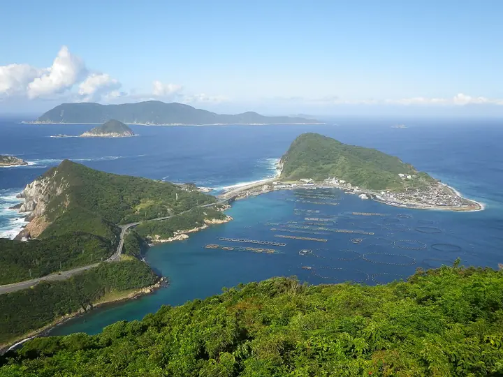
Mt. Imose (404 m) is the highest peak of Okinoshima, an island in the Pacific Ocean about 40 km west of Cape Ashizuri, Kochi Prefecture, and the high point of Sukumo City's offshore territory. It is included in the Shima-yama 100, Shikoku 100 Famous Mountains and Shikoku 100 Mountains lists, and the summit observation deck offers a 360-degree view encompassing neighboring Himejima and the Uwa Sea. The name derives from a legend in the Konjaku Monogatari about a brother (se) and sister (imo) who were shipwrecked and settled the island. The trail is open year-round; visitors reach the island by the Sukumo municipal ferry from Katashima Port and climb to the summit in about an hour.
Mt. Imose at a glance
- Weather: The most settled day in the next 7 days is Thu, November 5: clear, gusts up to 6 m/s. Fri, Nov 6, Sat, Nov 7, Mon, Nov 9: strong wind (gusts up to 21 m/s).
Mt. Imose weather (hourly, 14 days)
Sunrise today 06:28, sunset 17:18
| Tue, 11/3 | Wed, 11/4 | Thu, 11/5 | Fri, 11/6 | Sat, 11/7 | Sun, 11/8 | Mon, 11/9 | Tue, 11/10 | Wed, 11/11 | Thu, 11/12 | Fri, 11/13 | Sat, 11/14 | Sun, 11/15 | Mon, 11/16 | Tue, 11/17 | |||||||||||||||||||||||||||||||||||||||||||||||||||||||||||||||||||||||
|---|---|---|---|---|---|---|---|---|---|---|---|---|---|---|---|---|---|---|---|---|---|---|---|---|---|---|---|---|---|---|---|---|---|---|---|---|---|---|---|---|---|---|---|---|---|---|---|---|---|---|---|---|---|---|---|---|---|---|---|---|---|---|---|---|---|---|---|---|---|---|---|---|---|---|---|---|---|---|---|---|---|---|---|---|---|
| Japan time | 15 | 17 | 19 | 21 | 23 | 1 | 3 | 5 | 7 | 9 | 11 | 13 | 15 | 18 | 21 | 0 | 3 | 6 | 9 | 12 | 15 | 18 | 21 | 0 | 3 | 6 | 9 | 12 | 15 | 18 | 21 | 0 | 3 | 6 | 9 | 12 | 15 | 18 | 21 | 0 | 3 | 6 | 9 | 12 | 15 | 18 | 21 | 0 | 3 | 6 | 9 | 15 | 21 | 3 | 9 | 15 | 21 | 3 | 9 | 15 | 21 | 3 | 9 | 15 | 21 | 3 | 9 | 15 | 21 | 3 | 9 | 15 | 21 | 3 | 9 | 15 | 21 | 3 | 9 | 15 | 21 | 3 | 9 | 15 | |
 | |   |   | | | | |   |   |   | | | |   | | | | | | | |  |   | | | | | | | | | | | | | | | | | | | | | | | | | | | | | | |   | | | | | |   | | | |  | | | | | |   | | |   |   | |   | | | | | | | | ||
| Temperature | °C | 18° | 18° | 18° | 18° | 18° | 18° | 18° | 18° | 18° | 17° | 18° | 19° | 19° | 19° | 19° | 19° | 19° | 19° | 18° | 18° | 19° | 20° | 21° | 21° | 19° | 18° | 18° | 18° | 18° | 17° | 16° | 15° | 14° | 13° | 13° | 13° | 14° | 14° | 14° | 14° | 14° | 13° | 13° | 14° | 16° | 16° | 17° | 17° | 17° | 16° | 16° | 16° | 16° | 15° | 15° | 16° | 15° | 14° | 11° | 14° | 14° | 13° | 14° | 14° | 16° | 15° | 14° | 16° | 16° | 15° | 14° | 18° | 18° | 19° | 21° | 21° | 20° | 18° | 18° | 18° | 18° | 15° | 15° | 15° |
| Precipitation | mm | 0.4 | 0.3 | 0.3 | 0.2 | 0.1 | 1.0 | 4.0 | 0.9 | 0.8 | 3.8 | 13 | 2.2 | ||||||||||||||||||||||||||||||||||||||||||||||||||||||||||||||||||||||||
| New snow | cm | ||||||||||||||||||||||||||||||||||||||||||||||||||||||||||||||||||||||||||||||||||||
| Snow depth | cm | 0 | 0 | 0 | 0 | 0 | 0 | 0 | 0 | 0 | 0 | 0 | 0 | 0 | 0 | 0 | 0 | 0 | 0 | 0 | 0 | 0 | 0 | 0 | 0 | 0 | 0 | 0 | 0 | 0 | 0 | 0 | 0 | 0 | 0 | 0 | 0 | 0 | 0 | 0 | 0 | 0 | 0 | 0 | 0 | 0 | 0 | 0 | 0 | 0 | 0 | 0 | 0 | 0 | 0 | 0 | 0 | 0 | 0 | 0 | 0 | 0 | 0 | 0 | 0 | 0 | 0 | 0 | 0 | 0 | 0 | 0 | 0 | 0 | 0 | 0 | 0 | 0 | 0 | 0 | 0 | 0 | 0 | 0 | 0 |
| Wind | m/s | 11 | 10 | 7 | 6 | 5 | 5 | 5 | 4 | 4 | 6 | 6 | 6 | 6 | 6 | 5 | 4 | 5 | 3 | 4 | 3 | 1 | 4 | 8 | 9 | 14 | 15 | 14 | 15 | 15 | 16 | 16 | 16 | 15 | 14 | 13 | 12 | 12 | 9 | 7 | 7 | 7 | 5 | 3 | 4 | 5 | 2 | 2 | 4 | 6 | 9 | 9 | 11 | 7 | 9 | 11 | 13 | 14 | 13 | 9 | 12 | 6 | 6 | 7 | 8 | 9 | 9 | 7 | 8 | 3 | 5 | 4 | 6 | 7 | 6 | 10 | 11 | 4 | 13 | 13 | 13 | 7 | 3 | 7 | 10 |
| Wind gusts | m/s | 16 | 15 | 14 | 10 | 9 | 8 | 8 | 8 | 6 | 9 | 9 | 8 | 9 | 9 | 8 | 7 | 7 | 8 | 6 | 6 | 5 | 5 | 11 | 13 | 20 | 21 | 20 | 20 | 21 | 22 | 22 | 22 | 22 | 21 | 20 | 18 | 17 | 16 | 13 | 10 | 11 | 10 | 8 | 6 | 7 | 7 | 4 | 6 | 9 | 13 | 13 | 15 | 15 | 13 | 15 | 17 | 20 | 20 | 18 | 17 | 16 | 10 | 11 | 11 | 12 | 15 | 13 | 11 | 13 | 8 | 8 | 10 | 10 | 10 | 14 | 15 | 14 | 17 | 20 | 18 | 17 | 10 | 11 | 15 |
| Wind dir. | ↓ | ↓ | ↓ | ↓ | ↓ | ↓ | ↓ | ↓ | ↓ | ↓ | ↓ | ↓ | ↓ | ↓ | ↓ | ↓ | ↓ | ↓ | ↓ | ↓ | ↓ | ↓ | ↓ | ↓ | ↓ | ↓ | ↓ | ↓ | ↓ | ↓ | ↓ | ↓ | ↓ | ↓ | ↓ | ↓ | ↓ | ↓ | ↓ | ↓ | ↓ | ↓ | ↓ | ↓ | ↓ | ↓ | ↓ | ↓ | ↓ | ↓ | ↓ | ↓ | ↓ | ↓ | ↓ | ↓ | ↓ | ↓ | ↓ | ↓ | ↓ | ↓ | ↓ | ↓ | ↓ | ↓ | ↓ | ↓ | ↓ | ↓ | ↓ | ↓ | ↓ | ↓ | ↓ | ↓ | ↓ | ↓ | ↓ | ↓ | ↓ | ↓ | ↓ | ↓ | |
Huts, campsites and lodging near Mt. Imose
Lodging
- 民宿初福荘
- 高見旅館
- 民宿黒潮
- おきのしま旅館
- 島一旅館
Lists that include Mt. Imose
Shikoku 100 Famous Mountains · 100 Selected Island Mountains
Mt. Imose facts
- Elevation
- 404 m
- Location
- Sukumo, Kochi
32.726963, 132.554201 - Website
- www.city.sukumo.kochi.jp
- Trail Map
- www.city.sukumo.kochi.jp (PDF)
- Wikipedia
- ja.wikipedia.org