
Mt. Iimoriyama
飯盛山
Misaki, Osaka · Elevation 385 m
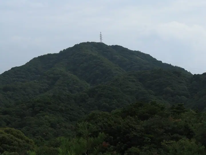
Mt. Iimoriyama is a 384.5 m peak in Tannowa, Misaki Town, Osaka, the highest point in the town and the westernmost summit of the Izumi Range that forms the Kisen Alps. Its conical, rice-mound silhouette gives the mountain its name, and the summit commands wide views over Osaka Bay, Awaji Island, Kansai International Airport, and the Akashi-Kaikyō Bridge. It lies within the Kisen Alps West sector of Osaka Prefectural Hannan-Misaki Nature Park, and Misaki Town maintains a 9.5 km historical hiking route from Tannowa Station that passes Katsuragi shugendō training sites and Yura Fortress ruins.
Mt. Iimoriyama at a glance
- Weather: The most settled day in the next 7 days is Mon, November 9: clear, gusts up to 7 m/s.
- Route: The shortest is Kisen Alps Station-to-Station Traverse from Mount Unzan to Mount Iimori: about 11 h 18 min, 19.6 km, about 1,260 m of climbing.
Mt. Iimoriyama weather (hourly, 14 days)
Sunrise today 06:20, sunset 17:06
| Tue, 11/3 | Wed, 11/4 | Thu, 11/5 | Fri, 11/6 | Sat, 11/7 | Sun, 11/8 | Mon, 11/9 | Tue, 11/10 | Wed, 11/11 | Thu, 11/12 | Fri, 11/13 | Sat, 11/14 | Sun, 11/15 | Mon, 11/16 | Tue, 11/17 | |||||||||||||||||||||||||||||||||||||||||||||||||||||||||||||||||||||||
|---|---|---|---|---|---|---|---|---|---|---|---|---|---|---|---|---|---|---|---|---|---|---|---|---|---|---|---|---|---|---|---|---|---|---|---|---|---|---|---|---|---|---|---|---|---|---|---|---|---|---|---|---|---|---|---|---|---|---|---|---|---|---|---|---|---|---|---|---|---|---|---|---|---|---|---|---|---|---|---|---|---|---|---|---|---|
| Japan time | 15 | 17 | 19 | 21 | 23 | 1 | 3 | 5 | 7 | 9 | 11 | 13 | 15 | 18 | 21 | 0 | 3 | 6 | 9 | 12 | 15 | 18 | 21 | 0 | 3 | 6 | 9 | 12 | 15 | 18 | 21 | 0 | 3 | 6 | 9 | 12 | 15 | 18 | 21 | 0 | 3 | 6 | 9 | 12 | 15 | 18 | 21 | 0 | 3 | 6 | 9 | 15 | 21 | 3 | 9 | 15 | 21 | 3 | 9 | 15 | 21 | 3 | 9 | 15 | 21 | 3 | 9 | 15 | 21 | 3 | 9 | 15 | 21 | 3 | 9 | 15 | 21 | 3 | 9 | 15 | 21 | 3 | 9 | 15 | |
  | |   |   | | | | | | |   | | | | |   | |   |   | |  |  | |   | | | | | | | | | | | |   | | | | | | | | | | | | | | | | | | |   | | | | | |   | | | |   |  | | | | | | | | | | | | | | | |  | | | ||
| Temperature | °C | 17° | 17° | 16° | 15° | 15° | 14° | 14° | 13° | 14° | 14° | 15° | 16° | 17° | 16° | 16° | 15° | 15° | 15° | 16° | 17° | 17° | 17° | 18° | 18° | 17° | 17° | 17° | 18° | 18° | 18° | 15° | 13° | 12° | 12° | 12° | 13° | 14° | 13° | 12° | 12° | 12° | 11° | 12° | 13° | 13° | 13° | 12° | 12° | 12° | 12° | 14° | 14° | 13° | 12° | 13° | 16° | 13° | 11° | 11° | 13° | 11° | 10° | 11° | 12° | 12° | 13° | 12° | 14° | 11° | 10° | 11° | 14° | 12° | 11° | 15° | 17° | 17° | 16° | 16° | 17° | 12° | 10° | 10° | 12° |
| Precipitation | mm | 4.4 | 0.6 | 0.4 | 0.4 | 0.2 | 0.6 | 0.6 | 1.1 | 0.3 | 0.1 | 0.7 | 0.2 | 0.2 | 2.0 | 4.0 | 12 | 0.2 | 0.4 | ||||||||||||||||||||||||||||||||||||||||||||||||||||||||||||||||||
| New snow | cm | ||||||||||||||||||||||||||||||||||||||||||||||||||||||||||||||||||||||||||||||||||||
| Snow depth | cm | 0 | 0 | 0 | 0 | 0 | 0 | 0 | 0 | 0 | 0 | 0 | 0 | 0 | 0 | 0 | 0 | 0 | 0 | 0 | 0 | 0 | 0 | 0 | 0 | 0 | 0 | 0 | 0 | 0 | 0 | 0 | 0 | 0 | 0 | 0 | 0 | 0 | 0 | 0 | 0 | 0 | 0 | 0 | 0 | 0 | 0 | 0 | 0 | 0 | 0 | 0 | 0 | 0 | 0 | 0 | 0 | 0 | 0 | 0 | 0 | 0 | 0 | 0 | 0 | 0 | 0 | 0 | 0 | 0 | 0 | 0 | 0 | 0 | 0 | 0 | 0 | 0 | 0 | 0 | 0 | 0 | 0 | 0 | 0 |
| Wind | m/s | 4 | 5 | 6 | 7 | 6 | 6 | 7 | 6 | 6 | 6 | 6 | 6 | 6 | 5 | 4 | 5 | 4 | 5 | 4 | 4 | 2 | 2 | 3 | 5 | 5 | 7 | 9 | 9 | 7 | 7 | 8 | 8 | 8 | 8 | 8 | 7 | 8 | 7 | 6 | 5 | 6 | 5 | 5 | 4 | 3 | 5 | 5 | 4 | 3 | 3 | 3 | 2 | 3 | 2 | 5 | 5 | 9 | 9 | 9 | 9 | 7 | 4 | 2 | 3 | 1 | 6 | 7 | 8 | 7 | 5 | 4 | 1 | 3 | 3 | 3 | 5 | 4 | 3 | 8 | 9 | 8 | 6 | 6 | 5 |
| Wind gusts | m/s | 8 | 7 | 10 | 11 | 10 | 10 | 11 | 11 | 10 | 10 | 10 | 10 | 10 | 9 | 8 | 7 | 8 | 8 | 7 | 7 | 7 | 4 | 5 | 8 | 10 | 12 | 14 | 14 | 14 | 11 | 13 | 14 | 14 | 13 | 13 | 13 | 12 | 12 | 12 | 10 | 9 | 9 | 9 | 9 | 7 | 7 | 8 | 7 | 6 | 6 | 6 | 7 | 6 | 6 | 8 | 9 | 14 | 16 | 15 | 15 | 14 | 11 | 7 | 7 | 6 | 9 | 12 | 13 | 13 | 11 | 8 | 8 | 5 | 6 | 6 | 8 | 10 | 10 | 13 | 14 | 15 | 12 | 11 | 10 |
| Wind dir. | ↓ | ↓ | ↓ | ↓ | ↓ | ↓ | ↓ | ↓ | ↓ | ↓ | ↓ | ↓ | ↓ | ↓ | ↓ | ↓ | ↓ | ↓ | ↓ | ↓ | ↓ | ↓ | ↓ | ↓ | ↓ | ↓ | ↓ | ↓ | ↓ | ↓ | ↓ | ↓ | ↓ | ↓ | ↓ | ↓ | ↓ | ↓ | ↓ | ↓ | ↓ | ↓ | ↓ | ↓ | ↓ | ↓ | ↓ | ↓ | ↓ | ↓ | ↓ | ↓ | ↓ | ↓ | ↓ | ↓ | ↓ | ↓ | ↓ | ↓ | ↓ | ↓ | ↓ | ↓ | ↓ | ↓ | ↓ | ↓ | ↓ | ↓ | ↓ | ↓ | ↓ | ↓ | ↓ | ↓ | ↓ | ↓ | ↓ | ↓ | ↓ | ↓ | ↓ | ↓ | |
Mt. Iimoriyama hiking routes
Hiking times are estimates calculated from the terrain.
Huts, campsites and lodging near Mt. Iimoriyama
Lodging
- 旅館かどや
- 竜宮館
- 海風館
Lists that include Mt. Iimoriyama
Mt. Iimoriyama facts
- Elevation
- 385 m
- Location
- Misaki, Osaka
34.300980, 135.177777 - Website
- www.town.misaki.osaka.jp
- Trail Map
- www.town.misaki.osaka.jp
- Wikipedia
- ja.wikipedia.org