
Mt. Ichiigadake
一位ヶ岳
Nagato, Yamaguchi · Elevation 672 m
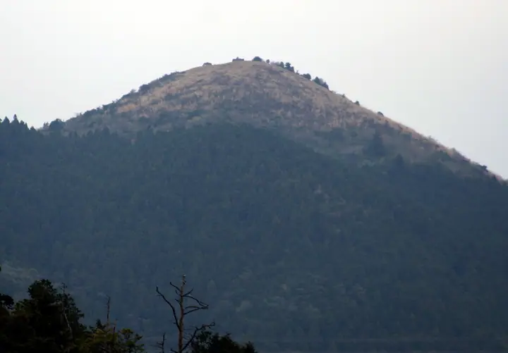
Ichiigadake is a 671.6 m sharp-pointed peak straddling the boundary between Nagato City and Shimonoseki City in Yamaguchi Prefecture. Its symmetrical cone has earned it the local nickname 'Toyota Fuji.' Tradition holds that holly (hiiragi) branches presented from this mountain on Setsubun during Empress Jingū's campaigns gave it the name 'Ichii' ('first rank'). At the eighth station, a colony of red Enkianthus campanulatus is designated a Yamaguchi Prefectural natural monument, while the open grassy summit commands a 360-degree panorama from Ōmijima and Yuya Bay across the mountains of the northern Nagato coast. Two trails—the Shiinoki route from Kawachi Shrine and the Hanase route—give access to the peak, which appears in the Yamaguchi Prefecture Hyakumeizan, the Bōchō Hyakuzan and Nihon-no-Yama 1000.
Mt. Ichiigadake at a glance
- Weather: The most settled day in the next 7 days is Mon, November 9: clear, gusts up to 10 m/s.
Mt. Ichiigadake weather (hourly, 14 days)
Sunrise today 06:37, sunset 17:22
| Tue, 11/3 | Wed, 11/4 | Thu, 11/5 | Fri, 11/6 | Sat, 11/7 | Sun, 11/8 | Mon, 11/9 | Tue, 11/10 | Wed, 11/11 | Thu, 11/12 | Fri, 11/13 | Sat, 11/14 | Sun, 11/15 | Mon, 11/16 | Tue, 11/17 | |||||||||||||||||||||||||||||||||||||||||||||||||||||||||||||||||||||||
|---|---|---|---|---|---|---|---|---|---|---|---|---|---|---|---|---|---|---|---|---|---|---|---|---|---|---|---|---|---|---|---|---|---|---|---|---|---|---|---|---|---|---|---|---|---|---|---|---|---|---|---|---|---|---|---|---|---|---|---|---|---|---|---|---|---|---|---|---|---|---|---|---|---|---|---|---|---|---|---|---|---|---|---|---|---|
| Japan time | 15 | 17 | 19 | 21 | 23 | 1 | 3 | 5 | 7 | 9 | 11 | 13 | 15 | 18 | 21 | 0 | 3 | 6 | 9 | 12 | 15 | 18 | 21 | 0 | 3 | 6 | 9 | 12 | 15 | 18 | 21 | 0 | 3 | 6 | 9 | 12 | 15 | 18 | 21 | 0 | 3 | 6 | 9 | 12 | 15 | 18 | 21 | 0 | 3 | 6 | 9 | 15 | 21 | 3 | 9 | 15 | 21 | 3 | 9 | 15 | 21 | 3 | 9 | 15 | 21 | 3 | 9 | 15 | 21 | 3 | 9 | 15 | 21 | 3 | 9 | 15 | 21 | 3 | 9 | 15 | 21 | 3 | 9 | 15 | |
  | |   | | | | | | | | |   | |   |   | | | | |   | |   | | |   | |  | | |  | | | | | | | | | | | | | | | | | | | | | |   | | | | | | |   | |   |  | | | |   |   | | | | | | | | | | | | | | | | | | ||
| Temperature | °C | 14° | 12° | 10° | 10° | 9° | 8° | 7° | 9° | 9° | 13° | 15° | 15° | 15° | 11° | 11° | 11° | 11° | 11° | 13° | 13° | 14° | 13° | 13° | 13° | 10° | 11° | 13° | 13° | 11° | 9° | 8° | 6° | 6° | 5° | 7° | 9° | 9° | 5° | 5° | 3° | 2° | 2° | 8° | 11° | 11° | 9° | 8° | 7° | 8° | 8° | 11° | 12° | 7° | 6° | 9° | 10° | 9° | 6° | 7° | 9° | 5° | 3° | 9° | 11° | 7° | 7° | 11° | 12° | 6° | 4° | 9° | 13° | 9° | 11° | 11° | 13° | 12° | 12° | 12° | 13° | 8° | 8° | 9° | 11° |
| Precipitation | mm | 0.5 | 4.1 | 6 | 3.4 | 3.7 | 0.5 | 0.1 | 0.8 | 0.6 | 0.6 | 0.3 | 0.1 | 0.2 | 2.9 | 18 | 7 | 0.5 | 1.0 | 0.8 | 2.2 | 0.2 | |||||||||||||||||||||||||||||||||||||||||||||||||||||||||||||||
| New snow | cm | ||||||||||||||||||||||||||||||||||||||||||||||||||||||||||||||||||||||||||||||||||||
| Snow depth | cm | 0 | 0 | 0 | 0 | 0 | 0 | 0 | 0 | 0 | 0 | 0 | 0 | 0 | 0 | 0 | 0 | 0 | 0 | 0 | 0 | 0 | 0 | 0 | 0 | 0 | 0 | 0 | 0 | 0 | 0 | 0 | 0 | 0 | 0 | 0 | 0 | 0 | 0 | 0 | 0 | 0 | 0 | 0 | 0 | 0 | 0 | 0 | 0 | 0 | 0 | 0 | 0 | 0 | 0 | 0 | 0 | 0 | 0 | 0 | 0 | 0 | 0 | 0 | 0 | 0 | 0 | 0 | 0 | 0 | 0 | 0 | 0 | 0 | 0 | 0 | 0 | 0 | 0 | 0 | 0 | 0 | 0 | 0 | 0 |
| Wind | m/s | 4 | 2 | 2 | 2 | 2 | 2 | 3 | 3 | 3 | 2 | 1 | 1 | 1 | 1 | 3 | 3 | 2 | 2 | 2 | 4 | 5 | 3 | 4 | 4 | 4 | 5 | 6 | 6 | 6 | 5 | 5 | 5 | 5 | 5 | 5 | 4 | 3 | 2 | 1 | 0 | 1 | 2 | 2 | 2 | 3 | 1 | 1 | 0 | 2 | 2 | 3 | 4 | 2 | 2 | 4 | 5 | 5 | 6 | 4 | 3 | 1 | 0 | 1 | 3 | 2 | 2 | 2 | 4 | 3 | 1 | 2 | 2 | 3 | 5 | 7 | 5 | 2 | 4 | 4 | 5 | 6 | 4 | 3 | 3 |
| Wind gusts | m/s | 10 | 9 | 5 | 6 | 6 | 5 | 6 | 6 | 6 | 6 | 6 | 5 | 4 | 4 | 6 | 7 | 7 | 5 | 6 | 8 | 13 | 12 | 9 | 9 | 9 | 10 | 13 | 15 | 15 | 14 | 12 | 13 | 12 | 12 | 11 | 11 | 10 | 8 | 4 | 2 | 3 | 4 | 5 | 6 | 8 | 7 | 3 | 2 | 3 | 6 | 8 | 10 | 9 | 5 | 8 | 12 | 12 | 13 | 13 | 10 | 8 | 2 | 4 | 9 | 8 | 5 | 6 | 10 | 9 | 6 | 5 | 8 | 8 | 12 | 15 | 16 | 14 | 9 | 9 | 13 | 13 | 13 | 9 | 9 |
| Wind dir. | ↓ | ↓ | ↓ | ↓ | ↓ | ↓ | ↓ | ↓ | ↓ | ↓ | ↓ | ↓ | ↓ | ↓ | ↓ | ↓ | ↓ | ↓ | ↓ | ↓ | ↓ | ↓ | ↓ | ↓ | ↓ | ↓ | ↓ | ↓ | ↓ | ↓ | ↓ | ↓ | ↓ | ↓ | ↓ | ↓ | ↓ | ↓ | ↓ | ↓ | ↓ | ↓ | ↓ | ↓ | ↓ | ↓ | ↓ | ↓ | ↓ | ↓ | ↓ | ↓ | ↓ | ↓ | ↓ | ↓ | ↓ | ↓ | ↓ | ↓ | ↓ | ↓ | ↓ | ↓ | ↓ | ↓ | ↓ | ↓ | ↓ | ↓ | ↓ | ↓ | ↓ | ↓ | ↓ | ↓ | ↓ | ↓ | ↓ | ↓ | ↓ | ↓ | ↓ | ↓ | |
Huts, campsites and lodging near Mt. Ichiigadake
Lodging
- 俵山湯ノ川
- たまや旅館
- さくま旅館
- 京屋
- 明治屋旅館
Lists that include Mt. Ichiigadake
Yamaguchi Prefecture 100 Famous Mountains · 1000 Mountains of Japan
Mt. Ichiigadake facts
- Also known as
- 豊田富士
- Elevation
- 672 m
- Location
- Nagato, Yamaguchi
34.291895, 131.067388 - Website
- nanavi.jp
- Wikipedia
- ja.wikipedia.org