
Mt. Gusukuyama
城山
Ie, Okinawa · Elevation 172 m
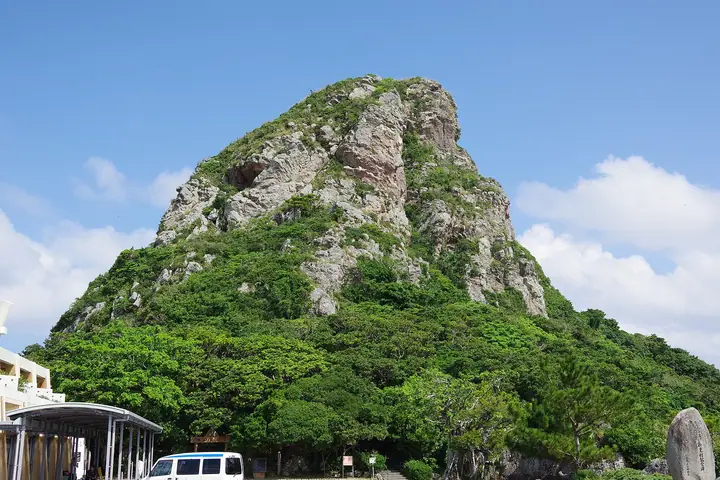
A 172-meter rock peak rising near the centre of Ie-jima, a small island off the Motobu Peninsula in Kunigami District, Okinawa Prefecture. Its distinctive eboshi-hat profile has made it the island's emblem, known popularly as "Iejima Tacchū". The peak preserves a rare surface exposure of "offscrape" geology in which a slab of bedrock some 70 million years older than the surrounding island sits atop younger formations — one of only a handful of such outcrops worldwide. The Gusuku-utaki shrine just below the summit is revered for prayers of safe sailing and bountiful harvest, and the peak is featured as No. 96 in the Japan Islands Centre's "100 Island Mountains" list and in the Bunken Tozan guide of Okinawa mountains.
Mt. Gusukuyama at a glance
- Weather: The most settled day in the next 7 days is Thu, November 5: clear, gusts up to 6 m/s. Sat, Nov 7: strong wind (gusts up to 18 m/s).
Mt. Gusukuyama weather (hourly, 14 days)
Sunrise today 06:39, sunset 17:46
| Tue, 11/3 | Wed, 11/4 | Thu, 11/5 | Fri, 11/6 | Sat, 11/7 | Sun, 11/8 | Mon, 11/9 | Tue, 11/10 | Wed, 11/11 | Thu, 11/12 | Fri, 11/13 | Sat, 11/14 | Sun, 11/15 | Mon, 11/16 | Tue, 11/17 | |||||||||||||||||||||||||||||||||||||||||||||||||||||||||||||||||||||||
|---|---|---|---|---|---|---|---|---|---|---|---|---|---|---|---|---|---|---|---|---|---|---|---|---|---|---|---|---|---|---|---|---|---|---|---|---|---|---|---|---|---|---|---|---|---|---|---|---|---|---|---|---|---|---|---|---|---|---|---|---|---|---|---|---|---|---|---|---|---|---|---|---|---|---|---|---|---|---|---|---|---|---|---|---|---|
| Japan time | 15 | 17 | 19 | 21 | 23 | 1 | 3 | 5 | 7 | 9 | 11 | 13 | 15 | 18 | 21 | 0 | 3 | 6 | 9 | 12 | 15 | 18 | 21 | 0 | 3 | 6 | 9 | 12 | 15 | 18 | 21 | 0 | 3 | 6 | 9 | 12 | 15 | 18 | 21 | 0 | 3 | 6 | 9 | 12 | 15 | 18 | 21 | 0 | 3 | 6 | 9 | 15 | 21 | 3 | 9 | 15 | 21 | 3 | 9 | 15 | 21 | 3 | 9 | 15 | 21 | 3 | 9 | 15 | 21 | 3 | 9 | 15 | 21 | 3 | 9 | 15 | 21 | 3 | 9 | 15 | 21 | 3 | 9 | 15 | |
  | |   | | | |  | |  | | | | |   |  | | | | | | |   | |   | | | | |   | | | | | | | | | |   | | | |   | | | | | | | | | | |   |   | |   | | | | | | | | | | | |  | | | | | |   | | | |   | | |  | | | ||
| Temperature | °C | 23° | 24° | 24° | 25° | 25° | 24° | 24° | 24° | 24° | 24° | 25° | 24° | 24° | 24° | 24° | 24° | 24° | 24° | 24° | 24° | 25° | 24° | 24° | 24° | 24° | 23° | 23° | 24° | 24° | 23° | 23° | 24° | 23° | 22° | 23° | 22° | 22° | 22° | 23° | 23° | 23° | 23° | 24° | 24° | 24° | 24° | 24° | 24° | 24° | 24° | 24° | 24° | 23° | 22° | 21° | 21° | 21° | 21° | 21° | 21° | 21° | 21° | 21° | 22° | 22° | 22° | 22° | 22° | 23° | 23° | 23° | 24° | 23° | 23° | 23° | 23° | 24° | 23° | 23° | 23° | 23° | 23° | 23° | 23° |
| Precipitation | mm | 0.2 | 0.6 | 0.8 | 0.4 | 0.2 | 1.0 | 0.6 | 1.4 | 4.9 | 0.7 | 0.4 | 0.6 | 4.7 | 11 | 10 | 0.1 | 0.2 | 0.5 | 0.2 | |||||||||||||||||||||||||||||||||||||||||||||||||||||||||||||||||
| New snow | cm | ||||||||||||||||||||||||||||||||||||||||||||||||||||||||||||||||||||||||||||||||||||
| Snow depth | cm | 0 | 0 | 0 | 0 | 0 | 0 | 0 | 0 | 0 | 0 | 0 | 0 | 0 | 0 | 0 | 0 | 0 | 0 | 0 | 0 | 0 | 0 | 0 | 0 | 0 | 0 | 0 | 0 | 0 | 0 | 0 | 0 | 0 | 0 | 0 | 0 | 0 | 0 | 0 | 0 | 0 | 0 | 0 | 0 | 0 | 0 | 0 | 0 | 0 | 0 | 0 | 0 | 0 | 0 | 0 | 0 | 0 | 0 | 0 | 0 | 0 | 0 | 0 | 0 | 0 | 0 | 0 | 0 | 0 | 0 | 0 | 0 | 0 | 0 | 0 | 0 | 0 | 0 | 0 | 0 | 0 | 0 | 0 | 0 |
| Wind | m/s | 9 | 10 | 10 | 8 | 8 | 8 | 8 | 9 | 9 | 8 | 7 | 7 | 6 | 7 | 5 | 2 | 1 | 2 | 4 | 3 | 3 | 6 | 6 | 6 | 8 | 8 | 7 | 7 | 7 | 10 | 12 | 11 | 13 | 13 | 13 | 13 | 13 | 12 | 11 | 9 | 9 | 9 | 7 | 6 | 4 | 5 | 5 | 5 | 5 | 6 | 6 | 5 | 5 | 3 | 13 | 13 | 13 | 11 | 10 | 8 | 7 | 5 | 6 | 6 | 5 | 7 | 8 | 6 | 7 | 5 | 7 | 6 | 7 | 7 | 8 | 11 | 5 | 4 | 7 | 6 | 5 | 4 | 6 | 6 |
| Wind gusts | m/s | 12 | 13 | 13 | 13 | 11 | 12 | 11 | 11 | 11 | 11 | 10 | 9 | 10 | 8 | 9 | 7 | 4 | 3 | 6 | 6 | 5 | 9 | 9 | 8 | 10 | 11 | 10 | 10 | 9 | 13 | 17 | 16 | 18 | 17 | 18 | 17 | 17 | 17 | 16 | 15 | 12 | 12 | 12 | 10 | 8 | 7 | 8 | 8 | 7 | 8 | 8 | 8 | 9 | 7 | 19 | 19 | 18 | 17 | 16 | 13 | 11 | 10 | 9 | 10 | 9 | 10 | 10 | 10 | 11 | 10 | 9 | 9 | 10 | 12 | 11 | 15 | 15 | 7 | 9 | 10 | 9 | 7 | 8 | 8 |
| Wind dir. | ↓ | ↓ | ↓ | ↓ | ↓ | ↓ | ↓ | ↓ | ↓ | ↓ | ↓ | ↓ | ↓ | ↓ | ↓ | ↓ | ↓ | ↓ | ↓ | ↓ | ↓ | ↓ | ↓ | ↓ | ↓ | ↓ | ↓ | ↓ | ↓ | ↓ | ↓ | ↓ | ↓ | ↓ | ↓ | ↓ | ↓ | ↓ | ↓ | ↓ | ↓ | ↓ | ↓ | ↓ | ↓ | ↓ | ↓ | ↓ | ↓ | ↓ | ↓ | ↓ | ↓ | ↓ | ↓ | ↓ | ↓ | ↓ | ↓ | ↓ | ↓ | ↓ | ↓ | ↓ | ↓ | ↓ | ↓ | ↓ | ↓ | ↓ | ↓ | ↓ | ↓ | ↓ | ↓ | ↓ | ↓ | ↓ | ↓ | ↓ | ↓ | ↓ | ↓ | ↓ | |
Huts, campsites and lodging near Mt. Gusukuyama
Lodging
- 伊江島ゲストハウス
- 民宿マルコポーロ
- 伊江島さんご荘
- 民宿かりゆし
- 民宿渚
Lists that include Mt. Gusukuyama
Mt. Gusukuyama facts
- Also known as
- 伊江島タッチュー
- Elevation
- 172 m
- Location
- Ie, Okinawa
26.719787, 127.807120 - Website
- www.iejima.org
- Wikipedia
- ja.wikipedia.org