
Mt. Futatsuyasan
二ツ箭山
Iwaki, Fukushima · Elevation 710 m
Mount Futatsuyasan (709.7 m) is a twin-peak crag in Ogawa-machi, Iwaki City, Fukushima, where the male-rock (Nantai) and female-rock (Nyotai) pinnacles stand like two arrows. Long worshipped as a guardian deity by seafarers, the climb passes the sacred Mitaki waterfall and chained scrambles, with red azaleas in spring and brilliant autumn foliage. Its position close to the Pacific keeps it accessible even in winter, and it is included in the Tohoku 100, Utsukushima 100 and Fukushima 30 selections.
Mt. Futatsuyasan at a glance
- Weather: The most settled day in the next 7 days is Mon, November 9: cloudy, gusts up to 5 m/s. Fri, Nov 6, Sat, Nov 7, Sun, Nov 8: strong wind (gusts up to 20 m/s).
- Route: The shortest is Mount Futatsuya Loop via the Stream Route, Nantai and Nyotai Peaks, and the Gassan New Trail: about 3 h 10 min, 5.5 km, about 580 m of climbing.
Mt. Futatsuyasan weather (hourly, 14 days)
Sunrise today 06:02, sunset 16:38
| Tue, 11/3 | Wed, 11/4 | Thu, 11/5 | Fri, 11/6 | Sat, 11/7 | Sun, 11/8 | Mon, 11/9 | Tue, 11/10 | Wed, 11/11 | Thu, 11/12 | Fri, 11/13 | Sat, 11/14 | Sun, 11/15 | Mon, 11/16 | Tue, 11/17 | |||||||||||||||||||||||||||||||||||||||||||||||||||||||||||||||||||||||
|---|---|---|---|---|---|---|---|---|---|---|---|---|---|---|---|---|---|---|---|---|---|---|---|---|---|---|---|---|---|---|---|---|---|---|---|---|---|---|---|---|---|---|---|---|---|---|---|---|---|---|---|---|---|---|---|---|---|---|---|---|---|---|---|---|---|---|---|---|---|---|---|---|---|---|---|---|---|---|---|---|---|---|---|---|---|
| Japan time | 15 | 17 | 19 | 21 | 23 | 1 | 3 | 5 | 7 | 9 | 11 | 13 | 15 | 18 | 21 | 0 | 3 | 6 | 9 | 12 | 15 | 18 | 21 | 0 | 3 | 6 | 9 | 12 | 15 | 18 | 21 | 0 | 3 | 6 | 9 | 12 | 15 | 18 | 21 | 0 | 3 | 6 | 9 | 12 | 15 | 18 | 21 | 0 | 3 | 6 | 9 | 15 | 21 | 3 | 9 | 15 | 21 | 3 | 9 | 15 | 21 | 3 | 9 | 15 | 21 | 3 | 9 | 15 | 21 | 3 | 9 | 15 | 21 | 3 | 9 | 15 | 21 | 3 | 9 | 15 | 21 | 3 | 9 | 15 | |
  |   | | |   | | |  | |  | | |   | |   | | | |   | | |   |   | |  | | | | | |   | | | | | | | | | | | | | | | | | | | |   | | | | | |   | |   | | | | |   |  | | | | | | | | | | | | | | | | | | | | ||
| Temperature | °C | 11° | 8° | 6° | 5° | 5° | 6° | 5° | 3° | 5° | 10° | 11° | 11° | 10° | 9° | 8° | 7° | 8° | 9° | 10° | 10° | 12° | 10° | 9° | 8° | 8° | 9° | 15° | 18° | 15° | 12° | 11° | 8° | 6° | 5° | 6° | 8° | 6° | 4° | 3° | 4° | 4° | 4° | 6° | 9° | 7° | 5° | 5° | 4° | 5° | 4° | 4° | 6° | 3° | 4° | 6° | 6° | 2° | 3° | 5° | 9° | 4° | 1° | 7° | 9° | 2° | 4° | 8° | 8° | 0° | -2° | 5° | 6° | 0° | 1° | 10° | 12° | 8° | 8° | 13° | 13° | 5° | 1° | 5° | 5° |
| Precipitation | mm | 0.9 | 4.0 | 8 | 8 | 9 | 16 | 0.2 | 0.8 | 1.2 | 0.6 | 0.4 | 0.1 | 0.1 | 1.2 | 0.4 | 3.9 | 21 | 0.2 | ||||||||||||||||||||||||||||||||||||||||||||||||||||||||||||||||||
| New snow | cm | ||||||||||||||||||||||||||||||||||||||||||||||||||||||||||||||||||||||||||||||||||||
| Snow depth | cm | 0 | 0 | 0 | 0 | 0 | 0 | 0 | 0 | 0 | 0 | 0 | 0 | 0 | 0 | 0 | 0 | 0 | 0 | 0 | 0 | 0 | 0 | 0 | 0 | 0 | 0 | 0 | 0 | 0 | 0 | 0 | 0 | 0 | 0 | 0 | 0 | 0 | 0 | 0 | 0 | 0 | 0 | 0 | 0 | 0 | 0 | 0 | 0 | 0 | 0 | 0 | 0 | 0 | 0 | 0 | 0 | 0 | 0 | 0 | 0 | 0 | 0 | 0 | 0 | 0 | 0 | 0 | 0 | 0 | 0 | 0 | 0 | 0 | 0 | 0 | 0 | 0 | 0 | 0 | 0 | 0 | 0 | 0 | 0 |
| Wind | m/s | 5 | 4 | 3 | 3 | 3 | 2 | 2 | 2 | 2 | 1 | 2 | 3 | 2 | 1 | 1 | 1 | 1 | 3 | 4 | 5 | 4 | 2 | 2 | 2 | 3 | 4 | 5 | 6 | 7 | 7 | 8 | 8 | 8 | 7 | 7 | 8 | 6 | 6 | 7 | 8 | 9 | 7 | 6 | 7 | 6 | 4 | 5 | 2 | 2 | 1 | 2 | 2 | 2 | 2 | 3 | 2 | 1 | 4 | 7 | 6 | 4 | 3 | 2 | 1 | 3 | 3 | 4 | 4 | 1 | 3 | 0 | 3 | 1 | 3 | 2 | 3 | 0 | 1 | 3 | 6 | 1 | 1 | 1 | 3 |
| Wind gusts | m/s | 14 | 12 | 10 | 8 | 9 | 8 | 6 | 5 | 6 | 5 | 7 | 8 | 7 | 5 | 5 | 4 | 3 | 6 | 9 | 10 | 12 | 8 | 6 | 5 | 7 | 9 | 12 | 15 | 16 | 17 | 19 | 19 | 20 | 20 | 19 | 20 | 19 | 16 | 17 | 20 | 21 | 22 | 18 | 17 | 17 | 15 | 12 | 11 | 6 | 5 | 5 | 5 | 5 | 6 | 8 | 9 | 6 | 9 | 20 | 20 | 16 | 11 | 8 | 9 | 7 | 7 | 12 | 10 | 9 | 7 | 7 | 8 | 6 | 8 | 8 | 9 | 8 | 7 | 7 | 16 | 15 | 6 | 5 | 9 |
| Wind dir. | ↓ | ↓ | ↓ | ↓ | ↓ | ↓ | ↓ | ↓ | ↓ | ↓ | ↓ | ↓ | ↓ | ↓ | ↓ | ↓ | ↓ | ↓ | ↓ | ↓ | ↓ | ↓ | ↓ | ↓ | ↓ | ↓ | ↓ | ↓ | ↓ | ↓ | ↓ | ↓ | ↓ | ↓ | ↓ | ↓ | ↓ | ↓ | ↓ | ↓ | ↓ | ↓ | ↓ | ↓ | ↓ | ↓ | ↓ | ↓ | ↓ | ↓ | ↓ | ↓ | ↓ | ↓ | ↓ | ↓ | ↓ | ↓ | ↓ | ↓ | ↓ | ↓ | ↓ | ↓ | ↓ | ↓ | ↓ | ↓ | ↓ | ↓ | ↓ | ↓ | ↓ | ↓ | ↓ | ↓ | ↓ | ↓ | ↓ | ↓ | ↓ | ↓ | ↓ | ↓ | |
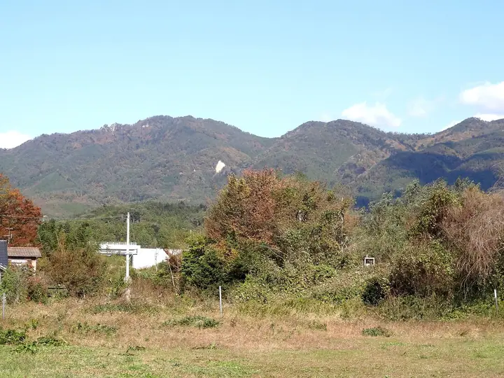
Mt. Futatsuyasan hiking routes
- Mount Futatsuya Loop via the Stream Route, Nantai and Nyotai Peaks, and the Gassan New Trail 5.5 km · Ascent 575 m parking
- Iwaki Futatsuya Grand Loop from the Twin Rock Peaks over the High Point and Gassan down to Kirigaoka 6.6 km · Ascent 605 m parking
Hiking times are estimates calculated from the terrain.
Lists that include Mt. Futatsuyasan
Tohoku 100 Famous Mountains · Utsukushima 100 Famous Mountains (Fukushima Prefecture) · 30 Peaks of Fukushima
Mt. Futatsuyasan facts
- Elevation
- 710 m
- Location
- Iwaki, Fukushima
37.173030, 140.870444 - Website
- www.tif.ne.jp
- Wikipedia
- ja.wikipedia.org