
Mt. Dodogamine
百々ヶ峰
Gifu, Gifu · Elevation 418 m
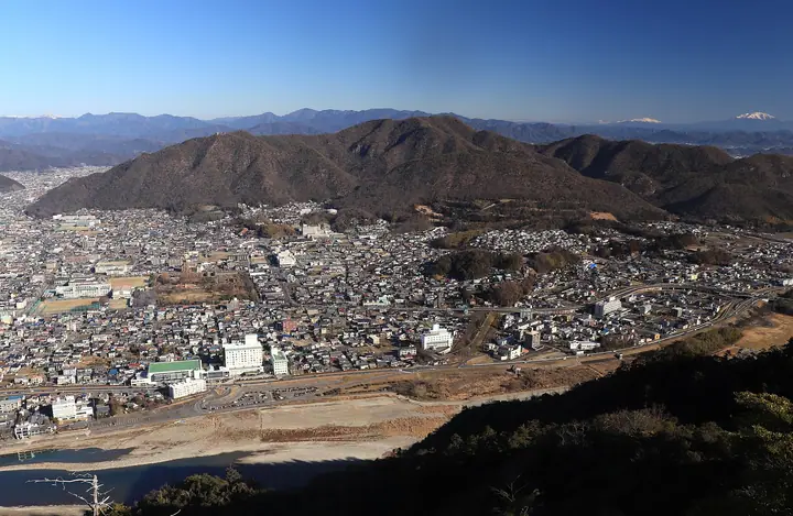
Mt. Dodogamine is the highest peak in Gifu City, Gifu Prefecture, rising 418 m on the north bank of the Nagara River opposite Mt. Kinkazan. The city manages the ~233-hectare Nagara-gawa Fureai-no-Mori park around its slopes, with the Shiki-no-Mori Center as the main trailhead and a network of routes — the Management Road, Campground, and Gongen-yama courses among them. A wooden observation deck on the summit overlooks the Nagara River, Mt. Kinkazan, and the Nōbi Plain. The peak is featured in Zoku Gifu Hyakuzan and the Tōkai Weekend Climbing Best 120 lists.
Mt. Dodogamine at a glance
- Weather: The most settled day in the next 7 days is Wed, November 4: clear, gusts up to 5 m/s.
- Route: The shortest is Dodogamine from Nagaragawa Fureai-no-Mori: about 2 h 40 min, 7.9 km, about 340 m of climbing.
Mt. Dodogamine weather (hourly, 14 days)
Sunrise today 06:16, sunset 16:57
| Tue, 11/3 | Wed, 11/4 | Thu, 11/5 | Fri, 11/6 | Sat, 11/7 | Sun, 11/8 | Mon, 11/9 | Tue, 11/10 | Wed, 11/11 | Thu, 11/12 | Fri, 11/13 | Sat, 11/14 | Sun, 11/15 | Mon, 11/16 | Tue, 11/17 | |||||||||||||||||||||||||||||||||||||||||||||||||||||||||||||||||||||||
|---|---|---|---|---|---|---|---|---|---|---|---|---|---|---|---|---|---|---|---|---|---|---|---|---|---|---|---|---|---|---|---|---|---|---|---|---|---|---|---|---|---|---|---|---|---|---|---|---|---|---|---|---|---|---|---|---|---|---|---|---|---|---|---|---|---|---|---|---|---|---|---|---|---|---|---|---|---|---|---|---|---|---|---|---|---|
| Japan time | 15 | 17 | 19 | 21 | 23 | 1 | 3 | 5 | 7 | 9 | 11 | 13 | 15 | 18 | 21 | 0 | 3 | 6 | 9 | 12 | 15 | 18 | 21 | 0 | 3 | 6 | 9 | 12 | 15 | 18 | 21 | 0 | 3 | 6 | 9 | 12 | 15 | 18 | 21 | 0 | 3 | 6 | 9 | 12 | 15 | 18 | 21 | 0 | 3 | 6 | 9 | 15 | 21 | 3 | 9 | 15 | 21 | 3 | 9 | 15 | 21 | 3 | 9 | 15 | 21 | 3 | 9 | 15 | 21 | 3 | 9 | 15 | 21 | 3 | 9 | 15 | 21 | 3 | 9 | 15 | 21 | 3 | 9 | 15 | |
 |  |   | | | | | |   | | |   | |   |   |   | | |   | | | | | | |   | |   | |  | | | | | | | | | | | | | | | | | | | | | | |   | | | | | | | | |  | | | | | | | | | |   | | | |   | | | | | | | | | ||
| Temperature | °C | 19° | 15° | 11° | 10° | 8° | 6° | 5° | 5° | 6° | 12° | 16° | 18° | 17° | 15° | 13° | 11° | 11° | 12° | 14° | 16° | 17° | 14° | 13° | 12° | 12° | 12° | 16° | 19° | 17° | 14° | 11° | 10° | 9° | 8° | 11° | 12° | 12° | 9° | 7° | 6° | 5° | 5° | 11° | 15° | 14° | 9° | 9° | 8° | 8° | 7° | 10° | 16° | 7° | 4° | 9° | 14° | 8° | 6° | 9° | 12° | 5° | 1° | 7° | 14° | 5° | 5° | 12° | 14° | 6° | 2° | 9° | 14° | 9° | 10° | 12° | 13° | 12° | 12° | 14° | 18° | 9° | 4° | 7° | 12° |
| Precipitation | mm | 7 | 7 | 2.0 | 0.5 | 0.2 | 2.7 | 2.9 | 0.3 | 0.7 | 0.2 | 0.1 | 0.4 | 6 | 10 | 0.2 | |||||||||||||||||||||||||||||||||||||||||||||||||||||||||||||||||||||
| New snow | cm | ||||||||||||||||||||||||||||||||||||||||||||||||||||||||||||||||||||||||||||||||||||
| Snow depth | cm | 0 | 0 | 0 | 0 | 0 | 0 | 0 | 0 | 0 | 0 | 0 | 0 | 0 | 0 | 0 | 0 | 0 | 0 | 0 | 0 | 0 | 0 | 0 | 0 | 0 | 0 | 0 | 0 | 0 | 0 | 0 | 0 | 0 | 0 | 0 | 0 | 0 | 0 | 0 | 0 | 0 | 0 | 0 | 0 | 0 | 0 | 0 | 0 | 0 | 0 | 0 | 0 | 0 | 0 | 0 | 0 | 0 | 0 | 0 | 0 | 0 | 0 | 0 | 0 | 0 | 0 | 0 | 0 | 0 | 0 | 0 | 0 | 0 | 0 | 0 | 0 | 0 | 0 | 0 | 0 | 0 | 0 | 0 | 0 |
| Wind | m/s | 3 | 4 | 2 | 1 | 1 | 1 | 1 | 1 | 1 | 0 | 1 | 2 | 1 | 0 | 0 | 1 | 1 | 0 | 0 | 1 | 1 | 0 | 1 | 1 | 1 | 1 | 2 | 5 | 6 | 5 | 3 | 4 | 3 | 2 | 4 | 5 | 6 | 4 | 3 | 3 | 3 | 3 | 3 | 4 | 3 | 1 | 1 | 1 | 1 | 0 | 1 | 4 | 1 | 2 | 0 | 1 | 1 | 2 | 4 | 5 | 3 | 1 | 1 | 2 | 1 | 0 | 2 | 5 | 3 | 1 | 1 | 2 | 2 | 2 | 0 | 2 | 2 | 1 | 1 | 6 | 2 | 2 | 0 | 2 |
| Wind gusts | m/s | 6 | 9 | 8 | 3 | 1 | 2 | 3 | 3 | 2 | 3 | 4 | 5 | 5 | 3 | 2 | 7 | 7 | 2 | 3 | 3 | 3 | 3 | 2 | 2 | 6 | 4 | 5 | 10 | 13 | 12 | 10 | 8 | 8 | 5 | 9 | 13 | 13 | 12 | 7 | 5 | 6 | 6 | 7 | 8 | 9 | 7 | 3 | 2 | 2 | 1 | 2 | 9 | 7 | 4 | 4 | 5 | 4 | 8 | 8 | 14 | 11 | 5 | 3 | 5 | 8 | 3 | 5 | 10 | 10 | 5 | 3 | 5 | 4 | 4 | 3 | 3 | 4 | 4 | 4 | 13 | 12 | 5 | 3 | 6 |
| Wind dir. | ↓ | ↓ | ↓ | ↓ | ↓ | ↓ | ↓ | ↓ | ↓ | ↓ | ↓ | ↓ | ↓ | ↓ | ↓ | ↓ | ↓ | ↓ | ↓ | ↓ | ↓ | ↓ | ↓ | ↓ | ↓ | ↓ | ↓ | ↓ | ↓ | ↓ | ↓ | ↓ | ↓ | ↓ | ↓ | ↓ | ↓ | ↓ | ↓ | ↓ | ↓ | ↓ | ↓ | ↓ | ↓ | ↓ | ↓ | ↓ | ↓ | ↓ | ↓ | ↓ | ↓ | ↓ | ↓ | ↓ | ↓ | ↓ | ↓ | ↓ | ↓ | ↓ | ↓ | ↓ | ↓ | ↓ | ↓ | ↓ | ↓ | ↓ | ↓ | ↓ | ↓ | ↓ | ↓ | ↓ | ↓ | ↓ | ↓ | ↓ | ↓ | ↓ | ↓ | ↓ | |
Mt. Dodogamine hiking routes
Hiking times are estimates calculated from the terrain.
Huts, campsites and lodging near Mt. Dodogamine
Lodging
- アルモニーテラッセ ウエディングホテル
- アルモニーテラッセ
- 岐阜グランドホテル
- 鵜匠の家 すぎ山
- 長良川観光ホテル石金
Mt. Dodogamine facts
- Elevation
- 418 m
- Location
- Gifu, Gifu
35.463243, 136.800202 - Website
- www.city.gifu.lg.jp
- Trail Map
- www.city.gifu.lg.jp (PDF)
- Wikipedia
- ja.wikipedia.org