
Mt. Chibusa
乳房山
Ogasawara Village, Tokyo · Elevation 462 m
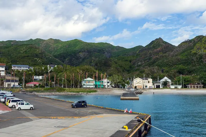
Mt. Chibusa rises 462.6 m at the center of Hahajima Island in Ogasawara Village, Tokyo, and is the highest peak among the inhabited islands of the Ogasawara archipelago. It lies within Ogasawara National Park and forms part of the UNESCO World Natural Heritage Site "Ogasawara Islands" inscribed in 2011, harboring numerous endemic plants and the endangered Hahajima meguro. Climbers must sanitize their boots at the trailhead to prevent invasive species. The peak is listed among the Shimayama 100, the 100 Famous Low Mountains of Japan, and the Tokyo 100.
Mt. Chibusa at a glance
- Weather: The most settled day in the next 7 days is Fri, November 6: clear, gusts up to 11 m/s. Thu, Nov 5: strong wind (gusts up to 20 m/s).
Mt. Chibusa weather (hourly, 14 days)
Sunrise today 05:42, sunset 16:48
| Tue, 11/3 | Wed, 11/4 | Thu, 11/5 | Fri, 11/6 | Sat, 11/7 | Sun, 11/8 | Mon, 11/9 | Tue, 11/10 | Wed, 11/11 | Thu, 11/12 | Fri, 11/13 | Sat, 11/14 | Sun, 11/15 | Mon, 11/16 | Tue, 11/17 | |||||||||||||||||||||||||||||||||||||||||||||||||||||||||||||||||||||||
|---|---|---|---|---|---|---|---|---|---|---|---|---|---|---|---|---|---|---|---|---|---|---|---|---|---|---|---|---|---|---|---|---|---|---|---|---|---|---|---|---|---|---|---|---|---|---|---|---|---|---|---|---|---|---|---|---|---|---|---|---|---|---|---|---|---|---|---|---|---|---|---|---|---|---|---|---|---|---|---|---|---|---|---|---|---|
| Japan time | 15 | 17 | 19 | 21 | 23 | 1 | 3 | 5 | 7 | 9 | 11 | 13 | 15 | 18 | 21 | 0 | 3 | 6 | 9 | 12 | 15 | 18 | 21 | 0 | 3 | 6 | 9 | 12 | 15 | 18 | 21 | 0 | 3 | 6 | 9 | 12 | 15 | 18 | 21 | 0 | 3 | 6 | 9 | 12 | 15 | 18 | 21 | 0 | 3 | 6 | 9 | 15 | 21 | 3 | 9 | 15 | 21 | 3 | 9 | 15 | 21 | 3 | 9 | 15 | 21 | 3 | 9 | 15 | 21 | 3 | 9 | 15 | 21 | 3 | 9 | 15 | 21 | 3 | 9 | 15 | 21 | 3 | 9 | 15 | |
  |   |   |   | | | | | |   |   | | |   | |   | |   |   | | | | | | | | |  | |  | | | | | |   | | |   | | | | | | | | | | | | | | | | | | | | | |   | | | | | | | | | | | | |  | | | | | | | | | | | ||
| Temperature | °C | 22° | 23° | 24° | 22° | 23° | 23° | 24° | 23° | 24° | 24° | 24° | 24° | 24° | 24° | 24° | 23° | 24° | 24° | 24° | 24° | 23° | 24° | 23° | 24° | 23° | 23° | 23° | 23° | 23° | 23° | 23° | 23° | 23° | 23° | 23° | 23° | 23° | 23° | 22° | 22° | 22° | 22° | 22° | 22° | 21° | 23° | 23° | 23° | 22° | 23° | 23° | 22° | 22° | 21° | 23° | 23° | 22° | 21° | 22° | 21° | 21° | 20° | 20° | 20° | 21° | 20° | 20° | 20° | 19° | 20° | 21° | 20° | 20° | 20° | 20° | 20° | 21° | 22° | 22° | 23° | 23° | 22° | 22° | 22° |
| Precipitation | mm | 0.3 | 2.0 | 1.4 | 0.1 | 0.3 | 0.2 | 0.1 | 0.3 | 0.3 | 0.3 | 0.4 | 0.7 | 0.3 | 0.6 | 1.1 | 0.4 | 0.3 | 0.1 | 0.1 | 0.2 | 0.1 | 8 | 6 | 0.9 | 1.6 | 0.6 | 0.1 | 2.9 | 1.1 | 2.5 | 2.4 | 1.0 | 14 | 44 | 0.2 | 0.4 | 0.4 | 0.1 | 0.7 | 0.6 | 0.6 | 0.3 | 1.3 | 0.7 | 0.4 | 0.1 | ||||||||||||||||||||||||||||||||||||||
| New snow | cm | ||||||||||||||||||||||||||||||||||||||||||||||||||||||||||||||||||||||||||||||||||||
| Snow depth | cm | 0 | 0 | 0 | 0 | 0 | 0 | 0 | 0 | 0 | 0 | 0 | 0 | 0 | 0 | 0 | 0 | 0 | 0 | 0 | 0 | 0 | 0 | 0 | 0 | 0 | 0 | 0 | 0 | 0 | 0 | 0 | 0 | 0 | 0 | 0 | 0 | 0 | 0 | 0 | 0 | 0 | 0 | 0 | 0 | 0 | 0 | 0 | 0 | 0 | 0 | 0 | 0 | 0 | 0 | 0 | 0 | 0 | 0 | 0 | 0 | 0 | 0 | 0 | 0 | 0 | 0 | 0 | 0 | 0 | 0 | 0 | 0 | 0 | 0 | 0 | 0 | 0 | 0 | 0 | 0 | 0 | 0 | 0 | 0 |
| Wind | m/s | 7 | 7 | 7 | 8 | 6 | 8 | 8 | 9 | 10 | 10 | 10 | 9 | 10 | 11 | 12 | 13 | 13 | 13 | 14 | 14 | 14 | 14 | 12 | 11 | 8 | 7 | 4 | 4 | 3 | 3 | 3 | 3 | 3 | 4 | 4 | 6 | 9 | 11 | 11 | 10 | 11 | 11 | 11 | 11 | 9 | 11 | 10 | 7 | 5 | 4 | 4 | 1 | 3 | 4 | 5 | 8 | 12 | 21 | 12 | 12 | 9 | 7 | 8 | 6 | 5 | 4 | 5 | 4 | 6 | 7 | 9 | 9 | 12 | 9 | 9 | 8 | 8 | 8 | 8 | 8 | 7 | 7 | 4 | 3 |
| Wind gusts | m/s | 10 | 9 | 9 | 12 | 12 | 11 | 10 | 11 | 12 | 13 | 13 | 12 | 13 | 14 | 15 | 16 | 16 | 17 | 19 | 19 | 20 | 18 | 18 | 16 | 14 | 11 | 9 | 6 | 5 | 5 | 4 | 4 | 4 | 5 | 5 | 8 | 11 | 14 | 14 | 14 | 14 | 14 | 14 | 15 | 14 | 14 | 14 | 13 | 9 | 7 | 6 | 6 | 6 | 7 | 9 | 11 | 16 | 54 | 29 | 16 | 15 | 12 | 11 | 10 | 10 | 7 | 7 | 7 | 11 | 10 | 14 | 12 | 16 | 16 | 13 | 12 | 11 | 11 | 11 | 11 | 11 | 11 | 9 | 6 |
| Wind dir. | ↓ | ↓ | ↓ | ↓ | ↓ | ↓ | ↓ | ↓ | ↓ | ↓ | ↓ | ↓ | ↓ | ↓ | ↓ | ↓ | ↓ | ↓ | ↓ | ↓ | ↓ | ↓ | ↓ | ↓ | ↓ | ↓ | ↓ | ↓ | ↓ | ↓ | ↓ | ↓ | ↓ | ↓ | ↓ | ↓ | ↓ | ↓ | ↓ | ↓ | ↓ | ↓ | ↓ | ↓ | ↓ | ↓ | ↓ | ↓ | ↓ | ↓ | ↓ | ↓ | ↓ | ↓ | ↓ | ↓ | ↓ | ↓ | ↓ | ↓ | ↓ | ↓ | ↓ | ↓ | ↓ | ↓ | ↓ | ↓ | ↓ | ↓ | ↓ | ↓ | ↓ | ↓ | ↓ | ↓ | ↓ | ↓ | ↓ | ↓ | ↓ | ↓ | ↓ | ↓ | |
Lists that include Mt. Chibusa
100 Low Mountains of Japan · 100 Selected Island Mountains · Elevations of 1003 Mountains of Japan
Mt. Chibusa facts
- Elevation
- 462 m
- Location
- Ogasawara Village, Tokyo
26.659512, 142.161444 - National Park
- 小笠原国立公園
- Website
- hahajima.com
- Wikipedia
- ja.wikipedia.org