
Mt. Boroishiyama
双石山
Miyazaki, Miyazaki · Elevation 509 m
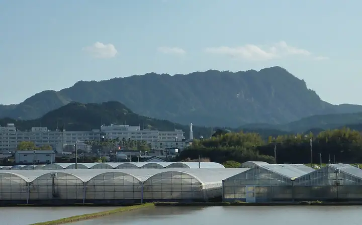
Mt. Boroishi-yama (509.4 m) rises in Kagami-su, Miyazaki City, Miyazaki Prefecture, cloaked in old-growth chinquapin, machilus and oak laurel forest and famed for grotesque sandstone rock formations registered as a national natural monument. The mountain forms the Miyazaki National Recreation Forest under the Forestry Agency; the standard route climbs from the Otani trailhead past Iwaya Shrine, Tengu-iwa and "Elephant's Graveyard" to the summit before descending the Kokonohira trailhead. It is included in the Kyūshū Hyakumeizan and Miyazaki Hyakuzan lists.
Mt. Boroishiyama at a glance
- Weather: The most settled day in the next 7 days is Sat, November 7: clear, gusts up to 6 m/s.
- Route: The shortest is Mount Boroishi Out-and-Back from Kotani Trailhead: about 3 h 28 min, 4.9 km, about 600 m of climbing.
Mt. Boroishiyama weather (hourly, 14 days)
Sunrise today 06:32, sunset 17:24
| Tue, 11/3 | Wed, 11/4 | Thu, 11/5 | Fri, 11/6 | Sat, 11/7 | Sun, 11/8 | Mon, 11/9 | Tue, 11/10 | Wed, 11/11 | Thu, 11/12 | Fri, 11/13 | Sat, 11/14 | Sun, 11/15 | Mon, 11/16 | Tue, 11/17 | |||||||||||||||||||||||||||||||||||||||||||||||||||||||||||||||||||||||
|---|---|---|---|---|---|---|---|---|---|---|---|---|---|---|---|---|---|---|---|---|---|---|---|---|---|---|---|---|---|---|---|---|---|---|---|---|---|---|---|---|---|---|---|---|---|---|---|---|---|---|---|---|---|---|---|---|---|---|---|---|---|---|---|---|---|---|---|---|---|---|---|---|---|---|---|---|---|---|---|---|---|---|---|---|---|
| Japan time | 15 | 17 | 19 | 21 | 23 | 1 | 3 | 5 | 7 | 9 | 11 | 13 | 15 | 18 | 21 | 0 | 3 | 6 | 9 | 12 | 15 | 18 | 21 | 0 | 3 | 6 | 9 | 12 | 15 | 18 | 21 | 0 | 3 | 6 | 9 | 12 | 15 | 18 | 21 | 0 | 3 | 6 | 9 | 12 | 15 | 18 | 21 | 0 | 3 | 6 | 9 | 15 | 21 | 3 | 9 | 15 | 21 | 3 | 9 | 15 | 21 | 3 | 9 | 15 | 21 | 3 | 9 | 15 | 21 | 3 | 9 | 15 | 21 | 3 | 9 | 15 | 21 | 3 | 9 | 15 | 21 | 3 | 9 | 15 | |
  |  |   |  |   | | | |   | |   |   |   |   | |   | | | | | | | | | | | | | | | |  | | | | | | | | | | | | | | |   | | | | | | | | | | | | | | | | | | | | | | | | | | | | | | |  | | |   | | | | ||
| Temperature | °C | 18° | 16° | 15° | 14° | 14° | 14° | 13° | 14° | 14° | 15° | 17° | 18° | 18° | 16° | 16° | 16° | 15° | 15° | 17° | 21° | 19° | 17° | 17° | 16° | 15° | 14° | 17° | 20° | 18° | 16° | 13° | 10° | 8° | 7° | 11° | 15° | 15° | 11° | 10° | 9° | 8° | 8° | 12° | 14° | 14° | 12° | 11° | 11° | 11° | 12° | 15° | 16° | 13° | 10° | 13° | 16° | 9° | 6° | 11° | 14° | 10° | 8° | 13° | 15° | 10° | 9° | 12° | 15° | 11° | 10° | 14° | 16° | 13° | 14° | 16° | 16° | 16° | 14° | 17° | 20° | 15° | 13° | 14° | 15° |
| Precipitation | mm | 0.4 | 0.4 | 0.2 | 0.2 | 0.9 | 0.1 | 1.0 | 0.2 | 0.1 | 1.7 | 10 | 16 | 0.1 | |||||||||||||||||||||||||||||||||||||||||||||||||||||||||||||||||||||||
| New snow | cm | ||||||||||||||||||||||||||||||||||||||||||||||||||||||||||||||||||||||||||||||||||||
| Snow depth | cm | 0 | 0 | 0 | 0 | 0 | 0 | 0 | 0 | 0 | 0 | 0 | 0 | 0 | 0 | 0 | 0 | 0 | 0 | 0 | 0 | 0 | 0 | 0 | 0 | 0 | 0 | 0 | 0 | 0 | 0 | 0 | 0 | 0 | 0 | 0 | 0 | 0 | 0 | 0 | 0 | 0 | 0 | 0 | 0 | 0 | 0 | 0 | 0 | 0 | 0 | 0 | 0 | 0 | 0 | 0 | 0 | 0 | 0 | 0 | 0 | 0 | 0 | 0 | 0 | 0 | 0 | 0 | 0 | 0 | 0 | 0 | 0 | 0 | 0 | 0 | 0 | 0 | 0 | 0 | 0 | 0 | 0 | 0 | 0 |
| Wind | m/s | 3 | 3 | 3 | 3 | 3 | 2 | 3 | 2 | 3 | 4 | 5 | 4 | 4 | 2 | 3 | 2 | 2 | 1 | 1 | 1 | 1 | 2 | 3 | 2 | 4 | 3 | 3 | 4 | 4 | 4 | 4 | 3 | 3 | 2 | 2 | 1 | 2 | 1 | 2 | 2 | 2 | 2 | 2 | 3 | 2 | 1 | 1 | 1 | 1 | 1 | 1 | 2 | 1 | 2 | 2 | 2 | 3 | 2 | 3 | 1 | 1 | 1 | 0 | 1 | 1 | 1 | 3 | 3 | 2 | 2 | 2 | 2 | 1 | 1 | 3 | 4 | 1 | 4 | 3 | 1 | 2 | 3 | 3 | 3 |
| Wind gusts | m/s | 8 | 8 | 8 | 8 | 7 | 7 | 7 | 8 | 8 | 10 | 12 | 12 | 10 | 9 | 7 | 7 | 7 | 6 | 4 | 5 | 5 | 7 | 8 | 8 | 9 | 10 | 9 | 10 | 12 | 11 | 10 | 9 | 8 | 7 | 6 | 5 | 6 | 6 | 5 | 6 | 5 | 5 | 7 | 8 | 7 | 4 | 3 | 3 | 3 | 3 | 4 | 7 | 5 | 5 | 6 | 8 | 8 | 7 | 7 | 8 | 6 | 3 | 3 | 5 | 5 | 3 | 8 | 10 | 8 | 6 | 5 | 6 | 6 | 4 | 9 | 10 | 12 | 9 | 9 | 8 | 6 | 7 | 8 | 8 |
| Wind dir. | ↓ | ↓ | ↓ | ↓ | ↓ | ↓ | ↓ | ↓ | ↓ | ↓ | ↓ | ↓ | ↓ | ↓ | ↓ | ↓ | ↓ | ↓ | ↓ | ↓ | ↓ | ↓ | ↓ | ↓ | ↓ | ↓ | ↓ | ↓ | ↓ | ↓ | ↓ | ↓ | ↓ | ↓ | ↓ | ↓ | ↓ | ↓ | ↓ | ↓ | ↓ | ↓ | ↓ | ↓ | ↓ | ↓ | ↓ | ↓ | ↓ | ↓ | ↓ | ↓ | ↓ | ↓ | ↓ | ↓ | ↓ | ↓ | ↓ | ↓ | ↓ | ↓ | ↓ | ↓ | ↓ | ↓ | ↓ | ↓ | ↓ | ↓ | ↓ | ↓ | ↓ | ↓ | ↓ | ↓ | ↓ | ↓ | ↓ | ↓ | ↓ | ↓ | ↓ | ↓ | |
Mt. Boroishiyama hiking routes
Hiking times are estimates calculated from the terrain.
Huts, campsites and lodging near Mt. Boroishiyama
Mountain huts
Lists that include Mt. Boroishiyama
Kyushu 100 Famous Mountains · 100 Mountains of Miyazaki · 1000 Mountains of Japan
Mt. Boroishiyama facts
- Elevation
- 509 m
- Location
- Miyazaki, Miyazaki
31.798188, 131.375890 - Website
- www.city.miyazaki.miyazaki.jp
- Trail Map
- www.city.miyazaki.miyazaki.jp (PDF)