
Mt. Atagoyama
愛宕山
Minato, Tokyo · Elevation 26 m
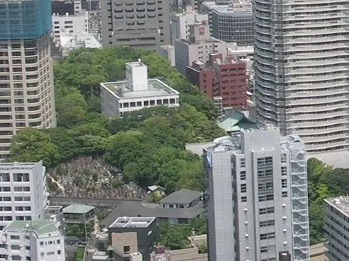
Atagoyama is a 25.7 m natural hill in Minato Ward, Tokyo, claimed as the highest natural rise in the city's twenty-three wards. The summit is crowned by Atago Shrine, founded in 1603 by order of Tokugawa Ieyasu as a fire-protection deity for Edo, and the 86-step, 40-degree staircase that climbs to it—made famous in 1634 when the samurai Magaki Heikurō rode his horse up to fetch plum blossoms for the Shogun—is celebrated as the 'Stone Steps of Success.' A third-class triangulation marker stands at the top, and the peak is included in the Tokyo Hyakumeizan and the 'Half-Day Tokyo Easy Climbs' list.
Mt. Atagoyama at a glance
- Weather: The most settled day in the next 7 days is Fri, November 6: clear, gusts up to 6 m/s.
Mt. Atagoyama weather (hourly, 14 days)
Sunrise today 06:04, sunset 16:45
| Tue, 11/3 | Wed, 11/4 | Thu, 11/5 | Fri, 11/6 | Sat, 11/7 | Sun, 11/8 | Mon, 11/9 | Tue, 11/10 | Wed, 11/11 | Thu, 11/12 | Fri, 11/13 | Sat, 11/14 | Sun, 11/15 | Mon, 11/16 | Tue, 11/17 | |||||||||||||||||||||||||||||||||||||||||||||||||||||||||||||||||||||||
|---|---|---|---|---|---|---|---|---|---|---|---|---|---|---|---|---|---|---|---|---|---|---|---|---|---|---|---|---|---|---|---|---|---|---|---|---|---|---|---|---|---|---|---|---|---|---|---|---|---|---|---|---|---|---|---|---|---|---|---|---|---|---|---|---|---|---|---|---|---|---|---|---|---|---|---|---|---|---|---|---|---|---|---|---|---|
| Japan time | 21 | 23 | 1 | 3 | 5 | 7 | 9 | 11 | 13 | 15 | 17 | 19 | 21 | 0 | 3 | 6 | 9 | 12 | 15 | 18 | 21 | 0 | 3 | 6 | 9 | 12 | 15 | 18 | 21 | 0 | 3 | 6 | 9 | 12 | 15 | 18 | 21 | 0 | 3 | 6 | 9 | 12 | 15 | 18 | 21 | 0 | 3 | 6 | 9 | 12 | 15 | 21 | 3 | 9 | 15 | 21 | 3 | 9 | 15 | 21 | 3 | 9 | 15 | 21 | 3 | 9 | 15 | 21 | 3 | 9 | 15 | 21 | 3 | 9 | 15 | 21 | 3 | 9 | 15 | 21 | 3 | 9 | 15 | 21 | |
  |   |   | | |   | |   | | | | | | | | | | |   | | |   |  | |  | | | | | | | | |   | | | | | | | | | | | | | | | | | | | |   |   | | | | |   |  | | | | | | | | | | | | | | | | | | | | | | | | ||
| Temperature | °C | 15° | 15° | 14° | 13° | 13° | 13° | 14° | 14° | 14° | 14° | 13° | 12° | 12° | 12° | 12° | 13° | 15° | 17° | 18° | 17° | 16° | 15° | 14° | 14° | 17° | 21° | 21° | 19° | 17° | 15° | 14° | 13° | 14° | 17° | 17° | 13° | 11° | 10° | 9° | 9° | 11° | 14° | 15° | 13° | 12° | 10° | 9° | 8° | 9° | 10° | 11° | 11° | 10° | 11° | 13° | 9° | 8° | 13° | 14° | 11° | 8° | 11° | 14° | 12° | 9° | 13° | 15° | 9° | 6° | 9° | 13° | 11° | 8° | 10° | 18° | 17° | 11° | 14° | 21° | 13° | 11° | 10° | 12° | 10° |
| Precipitation | mm | 0.1 | 0.2 | 0.4 | 0.1 | 0.9 | 1.8 | 3.3 | 4.3 | 8 | 12 | 8 | 0.3 | 2.5 | 2.5 | 0.8 | 0.3 | 0.2 | 0.3 | 0.2 | 3.4 | 1.8 | 15 | 0.4 | |||||||||||||||||||||||||||||||||||||||||||||||||||||||||||||
| New snow | cm | ||||||||||||||||||||||||||||||||||||||||||||||||||||||||||||||||||||||||||||||||||||
| Snow depth | cm | 0 | 0 | 0 | 0 | 0 | 0 | 0 | 0 | 0 | 0 | 0 | 0 | 0 | 0 | 0 | 0 | 0 | 0 | 0 | 0 | 0 | 0 | 0 | 0 | 0 | 0 | 0 | 0 | 0 | 0 | 0 | 0 | 0 | 0 | 0 | 0 | 0 | 0 | 0 | 0 | 0 | 0 | 0 | 0 | 0 | 0 | 0 | 0 | 0 | 0 | 0 | 0 | 0 | 0 | 0 | 0 | 0 | 0 | 0 | 0 | 0 | 0 | 0 | 0 | 0 | 0 | 0 | 0 | 0 | 0 | 0 | 0 | 0 | 0 | 0 | 0 | 0 | 0 | 0 | 0 | 0 | 0 | 0 | 0 |
| Wind | m/s | 1 | 2 | 3 | 3 | 3 | 2 | 2 | 2 | 2 | 2 | 3 | 4 | 4 | 5 | 5 | 6 | 6 | 3 | 2 | 1 | 1 | 1 | 1 | 1 | 1 | 1 | 2 | 1 | 3 | 3 | 3 | 3 | 2 | 2 | 3 | 4 | 3 | 4 | 4 | 4 | 3 | 2 | 1 | 1 | 2 | 2 | 3 | 3 | 3 | 3 | 2 | 2 | 3 | 2 | 3 | 1 | 2 | 5 | 6 | 4 | 2 | 2 | 1 | 2 | 1 | 3 | 6 | 2 | 2 | 1 | 1 | 1 | 2 | 1 | 2 | 4 | 2 | 1 | 4 | 5 | 2 | 2 | 2 | 1 |
| Wind gusts | m/s | 3 | 5 | 6 | 6 | 6 | 6 | 5 | 6 | 6 | 6 | 7 | 7 | 9 | 10 | 12 | 13 | 13 | 13 | 8 | 4 | 3 | 2 | 2 | 5 | 4 | 5 | 6 | 5 | 5 | 8 | 7 | 9 | 7 | 7 | 7 | 8 | 8 | 8 | 9 | 9 | 8 | 8 | 6 | 4 | 5 | 6 | 6 | 8 | 8 | 8 | 7 | 6 | 7 | 7 | 9 | 7 | 4 | 13 | 16 | 13 | 8 | 5 | 5 | 4 | 5 | 6 | 13 | 14 | 5 | 4 | 5 | 4 | 5 | 5 | 6 | 10 | 13 | 6 | 9 | 17 | 12 | 6 | 7 | 5 |
| Wind dir. | ↓ | ↓ | ↓ | ↓ | ↓ | ↓ | ↓ | ↓ | ↓ | ↓ | ↓ | ↓ | ↓ | ↓ | ↓ | ↓ | ↓ | ↓ | ↓ | ↓ | ↓ | ↓ | ↓ | ↓ | ↓ | ↓ | ↓ | ↓ | ↓ | ↓ | ↓ | ↓ | ↓ | ↓ | ↓ | ↓ | ↓ | ↓ | ↓ | ↓ | ↓ | ↓ | ↓ | ↓ | ↓ | ↓ | ↓ | ↓ | ↓ | ↓ | ↓ | ↓ | ↓ | ↓ | ↓ | ↓ | ↓ | ↓ | ↓ | ↓ | ↓ | ↓ | ↓ | ↓ | ↓ | ↓ | ↓ | ↓ | ↓ | ↓ | ↓ | ↓ | ↓ | ↓ | ↓ | ↓ | ↓ | ↓ | ↓ | ↓ | ↓ | ↓ | ↓ | ↓ | |
Huts, campsites and lodging near Mt. Atagoyama
Lodging
- ANdAZ
- The Edition Toranomon Tokyo
- ファーストキャビン愛宕山
- The Okura Tokyo
- Hotel the b shimbashi
Mt. Atagoyama facts
- Also known as
- 愛宕神社
- Elevation
- 26 m
- Location
- Minato, Tokyo
35.664767, 139.748744 - Website
- www.atago-jinja.com
- Access Information
- www.atago-jinja.com
- Wikipedia
- ja.wikipedia.org