
Mount Ryūmon
龍門山
Kinokawa, Wakayama · Elevation 756 m
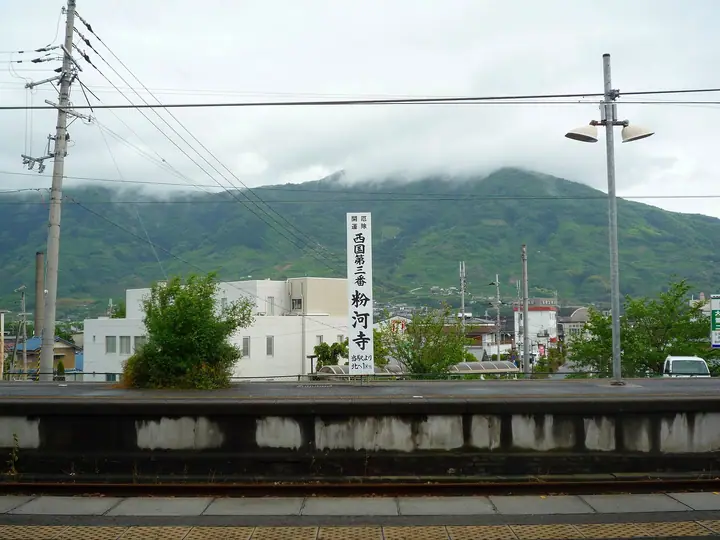
Mount Ryūmon is a 755.9 m peak in Kinokawa City, Wakayama Prefecture, and the highest of the Ryūmon mountain range. Its conical, Fuji-like profile has earned it the affectionate nickname 'Kishū Fuji'. The summit overlooks the Kinokawa basin and on clear days reaches as far as Awaji Island, while the trails pass landmarks such as the prefecturally designated Jishaku-iwa (Magnet Rock), Myōjin-iwa, a wind cave, and a small shrine to the dragon-king Zen'nyo. It is a habitat for Kii-shimotsuke (a Wakayama endemic) and the endangered Luehdorfia Gifu butterfly, and is counted among the Kansai Hyakumeizan, Kinki Hyakumeizan, and 100 Local Fujis.
Mount Ryūmon at a glance
- Weather: The most settled day in the next 7 days is Mon, November 9: clear, gusts up to 7 m/s.
- Route: The shortest is Mount Ryūmon Tashiro and Central Course Circuit: about 4 h 25 min, 9.1 km, about 730 m of climbing.
Mount Ryūmon weather (hourly, 14 days)
Sunrise today 06:19, sunset 17:05
| Tue, 11/3 | Wed, 11/4 | Thu, 11/5 | Fri, 11/6 | Sat, 11/7 | Sun, 11/8 | Mon, 11/9 | Tue, 11/10 | Wed, 11/11 | Thu, 11/12 | Fri, 11/13 | Sat, 11/14 | Sun, 11/15 | Mon, 11/16 | Tue, 11/17 | |||||||||||||||||||||||||||||||||||||||||||||||||||||||||||||||||||||||
|---|---|---|---|---|---|---|---|---|---|---|---|---|---|---|---|---|---|---|---|---|---|---|---|---|---|---|---|---|---|---|---|---|---|---|---|---|---|---|---|---|---|---|---|---|---|---|---|---|---|---|---|---|---|---|---|---|---|---|---|---|---|---|---|---|---|---|---|---|---|---|---|---|---|---|---|---|---|---|---|---|---|---|---|---|---|
| Japan time | 15 | 17 | 19 | 21 | 23 | 1 | 3 | 5 | 7 | 9 | 11 | 13 | 15 | 18 | 21 | 0 | 3 | 6 | 9 | 12 | 15 | 18 | 21 | 0 | 3 | 6 | 9 | 12 | 15 | 18 | 21 | 0 | 3 | 6 | 9 | 12 | 15 | 18 | 21 | 0 | 3 | 6 | 9 | 12 | 15 | 18 | 21 | 0 | 3 | 6 | 9 | 15 | 21 | 3 | 9 | 15 | 21 | 3 | 9 | 15 | 21 | 3 | 9 | 15 | 21 | 3 | 9 | 15 | 21 | 3 | 9 | 15 | 21 | 3 | 9 | 15 | 21 | 3 | 9 | 15 | 21 | 3 | 9 | 15 | |
  |   |   | | | | | | | | | | |   |   |   | | |   | | |  | | | | |   | | | | |   | | | |   | | | | | | | | | | | | | | |  | | | | | |   | | | |   |  | | | | | | | | | | | | | | | | |   | | |  | | | ||
| Temperature | °C | 14° | 11° | 9° | 9° | 8° | 7° | 7° | 7° | 8° | 11° | 13° | 15° | 14° | 11° | 11° | 11° | 11° | 11° | 14° | 15° | 17° | 13° | 12° | 14° | 13° | 12° | 13° | 15° | 15° | 12° | 10° | 8° | 6° | 7° | 8° | 9° | 10° | 7° | 4° | 3° | 4° | 3° | 8° | 11° | 10° | 6° | 7° | 6° | 6° | 6° | 11° | 12° | 7° | 4° | 10° | 11° | 7° | 5° | 7° | 9° | 3° | 2° | 7° | 9° | 4° | 4° | 8° | 10° | 3° | 2° | 8° | 13° | 4° | 5° | 13° | 15° | 12° | 12° | 12° | 13° | 7° | 3° | 7° | 9° |
| Precipitation | mm | 0.4 | 0.1 | 1.1 | 1.0 | 0.6 | 0.5 | 0.2 | 0.2 | 0.2 | 0.9 | 0.3 | 0.1 | 2.9 | 14 | 1.5 | 2.0 | 0.1 | |||||||||||||||||||||||||||||||||||||||||||||||||||||||||||||||||||
| New snow | cm | ||||||||||||||||||||||||||||||||||||||||||||||||||||||||||||||||||||||||||||||||||||
| Snow depth | cm | 0 | 0 | 0 | 0 | 0 | 0 | 0 | 0 | 0 | 0 | 0 | 0 | 0 | 0 | 0 | 0 | 0 | 0 | 0 | 0 | 0 | 0 | 0 | 0 | 0 | 0 | 0 | 0 | 0 | 0 | 0 | 0 | 0 | 0 | 0 | 0 | 0 | 0 | 0 | 0 | 0 | 0 | 0 | 0 | 0 | 0 | 0 | 0 | 0 | 0 | 0 | 0 | 0 | 0 | 0 | 0 | 0 | 0 | 0 | 0 | 0 | 0 | 0 | 0 | 0 | 0 | 0 | 0 | 0 | 0 | 0 | 0 | 0 | 0 | 0 | 0 | 0 | 0 | 0 | 0 | 0 | 0 | 0 | 0 |
| Wind | m/s | 3 | 1 | 2 | 2 | 2 | 3 | 3 | 3 | 3 | 3 | 3 | 3 | 2 | 1 | 2 | 0 | 2 | 2 | 1 | 1 | 2 | 0 | 1 | 3 | 3 | 2 | 3 | 4 | 5 | 2 | 4 | 4 | 3 | 3 | 5 | 4 | 5 | 3 | 2 | 1 | 1 | 2 | 3 | 4 | 3 | 2 | 2 | 1 | 1 | 2 | 1 | 3 | 1 | 1 | 2 | 3 | 3 | 4 | 5 | 5 | 2 | 1 | 1 | 2 | 0 | 1 | 4 | 5 | 2 | 2 | 1 | 2 | 1 | 2 | 2 | 3 | 3 | 2 | 3 | 4 | 3 | 2 | 3 | 3 |
| Wind gusts | m/s | 8 | 8 | 4 | 6 | 6 | 6 | 7 | 7 | 8 | 8 | 9 | 8 | 7 | 5 | 4 | 4 | 4 | 4 | 4 | 4 | 5 | 5 | 5 | 8 | 9 | 8 | 9 | 11 | 12 | 11 | 9 | 10 | 10 | 7 | 12 | 13 | 12 | 11 | 8 | 5 | 4 | 5 | 8 | 10 | 10 | 9 | 6 | 4 | 3 | 3 | 4 | 7 | 7 | 4 | 5 | 8 | 8 | 10 | 13 | 15 | 13 | 5 | 4 | 7 | 5 | 4 | 9 | 12 | 11 | 6 | 6 | 6 | 6 | 5 | 6 | 8 | 9 | 8 | 8 | 11 | 11 | 9 | 7 | 9 |
| Wind dir. | ↓ | ↓ | ↓ | ↓ | ↓ | ↓ | ↓ | ↓ | ↓ | ↓ | ↓ | ↓ | ↓ | ↓ | ↓ | ↓ | ↓ | ↓ | ↓ | ↓ | ↓ | ↓ | ↓ | ↓ | ↓ | ↓ | ↓ | ↓ | ↓ | ↓ | ↓ | ↓ | ↓ | ↓ | ↓ | ↓ | ↓ | ↓ | ↓ | ↓ | ↓ | ↓ | ↓ | ↓ | ↓ | ↓ | ↓ | ↓ | ↓ | ↓ | ↓ | ↓ | ↓ | ↓ | ↓ | ↓ | ↓ | ↓ | ↓ | ↓ | ↓ | ↓ | ↓ | ↓ | ↓ | ↓ | ↓ | ↓ | ↓ | ↓ | ↓ | ↓ | ↓ | ↓ | ↓ | ↓ | ↓ | ↓ | ↓ | ↓ | ↓ | ↓ | ↓ | ↓ | |
Mount Ryūmon hiking routes
Hiking times are estimates calculated from the terrain.
Lists that include Mount Ryūmon
100 Fujis of Japan · Kansai 100 Famous Mountains · Kinki 100 Famous Mountains · Elevations of 1003 Mountains of Japan · 1000 Mountains of Japan
Mount Ryūmon facts
- Also known as
- 紀州富士
- Elevation
- 756 m
- Location
- Kinokawa, Wakayama
34.237998, 135.411333 - Website
- www.city.kinokawa.lg.jp
- Trail Map
- www.city.kinokawa.lg.jp (PDF)
- Access Information
- www.pref.wakayama.lg.jp
- Wikipedia
- ja.wikipedia.org