
Mount Noro
野呂山
Kure, Hiroshima · Elevation 839 m
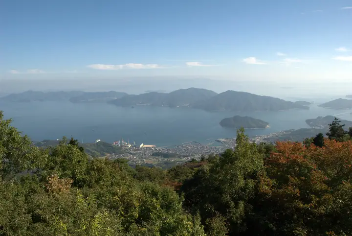
The Sazanami Skyline road reaches near the summit. Kabutoiwa Observatory overlooks the islands of the Seto Inland Sea and, on clear days, the Ishizuchi mountains of Shikoku. Large rock formations include Ogasaneiwa and Gankai. Cherry blossoms and azaleas in spring and autumn foliage add seasonal colour.
Mount Noro at a glance
- Weather: The most settled day in the next 7 days is Mon, November 9: clear, gusts up to 7 m/s.
Mount Noro weather (hourly, 14 days)
Sunrise today 06:30, sunset 17:16
| Tue, 11/3 | Wed, 11/4 | Thu, 11/5 | Fri, 11/6 | Sat, 11/7 | Sun, 11/8 | Mon, 11/9 | Tue, 11/10 | Wed, 11/11 | Thu, 11/12 | Fri, 11/13 | Sat, 11/14 | Sun, 11/15 | Mon, 11/16 | Tue, 11/17 | |||||||||||||||||||||||||||||||||||||||||||||||||||||||||||||||||||||||
|---|---|---|---|---|---|---|---|---|---|---|---|---|---|---|---|---|---|---|---|---|---|---|---|---|---|---|---|---|---|---|---|---|---|---|---|---|---|---|---|---|---|---|---|---|---|---|---|---|---|---|---|---|---|---|---|---|---|---|---|---|---|---|---|---|---|---|---|---|---|---|---|---|---|---|---|---|---|---|---|---|---|---|---|---|---|
| Japan time | 15 | 17 | 19 | 21 | 23 | 1 | 3 | 5 | 7 | 9 | 11 | 13 | 15 | 18 | 21 | 0 | 3 | 6 | 9 | 12 | 15 | 18 | 21 | 0 | 3 | 6 | 9 | 12 | 15 | 18 | 21 | 0 | 3 | 6 | 9 | 12 | 15 | 18 | 21 | 0 | 3 | 6 | 9 | 12 | 15 | 18 | 21 | 0 | 3 | 6 | 9 | 15 | 21 | 3 | 9 | 15 | 21 | 3 | 9 | 15 | 21 | 3 | 9 | 15 | 21 | 3 | 9 | 15 | 21 | 3 | 9 | 15 | 21 | 3 | 9 | 15 | 21 | 3 | 9 | 15 | 21 | 3 | 9 | 15 | |
  |   |   |  | | |   | |   | | | | | |   | | | |   |   | |   | |   | |  |  | | | | | | | | | | | | | | | | | | | | | | | | | |   | | | | |   | | | | | | |  | | | | | | | | | | |   | | | | | |  | | | ||
| Temperature | °C | 15° | 12° | 10° | 9° | 9° | 8° | 8° | 9° | 9° | 11° | 12° | 13° | 13° | 12° | 11° | 10° | 10° | 10° | 12° | 15° | 15° | 13° | 13° | 14° | 11° | 11° | 13° | 15° | 14° | 9° | 8° | 7° | 6° | 5° | 7° | 10° | 10° | 7° | 4° | 4° | 3° | 4° | 8° | 10° | 11° | 10° | 8° | 8° | 7° | 7° | 10° | 13° | 7° | 5° | 10° | 11° | 7° | 5° | 6° | 10° | 4° | 3° | 8° | 11° | 7° | 5° | 9° | 12° | 6° | 4° | 8° | 12° | 8° | 8° | 11° | 11° | 11° | 11° | 12° | 15° | 8° | 5° | 6° | 9° |
| Precipitation | mm | 0.5 | 0.1 | 1.1 | 1.2 | 0.4 | 0.7 | 1.5 | 5.0 | 2.4 | 2.1 | 0.3 | 0.6 | 0.1 | 3.1 | 14 | 0.7 | ||||||||||||||||||||||||||||||||||||||||||||||||||||||||||||||||||||
| New snow | cm | ||||||||||||||||||||||||||||||||||||||||||||||||||||||||||||||||||||||||||||||||||||
| Snow depth | cm | 0 | 0 | 0 | 0 | 0 | 0 | 0 | 0 | 0 | 0 | 0 | 0 | 0 | 0 | 0 | 0 | 0 | 0 | 0 | 0 | 0 | 0 | 0 | 0 | 0 | 0 | 0 | 0 | 0 | 0 | 0 | 0 | 0 | 0 | 0 | 0 | 0 | 0 | 0 | 0 | 0 | 0 | 0 | 0 | 0 | 0 | 0 | 0 | 0 | 0 | 0 | 0 | 0 | 0 | 0 | 0 | 0 | 0 | 0 | 0 | 0 | 0 | 0 | 0 | 0 | 0 | 0 | 0 | 0 | 0 | 0 | 0 | 0 | 0 | 0 | 0 | 0 | 0 | 0 | 0 | 0 | 0 | 0 | 0 |
| Wind | m/s | 2 | 4 | 5 | 4 | 3 | 3 | 3 | 3 | 4 | 5 | 6 | 5 | 5 | 4 | 5 | 3 | 2 | 3 | 2 | 2 | 3 | 1 | 2 | 4 | 3 | 3 | 2 | 5 | 5 | 4 | 3 | 4 | 4 | 3 | 4 | 3 | 3 | 3 | 3 | 2 | 3 | 2 | 3 | 3 | 3 | 2 | 2 | 2 | 2 | 2 | 2 | 2 | 3 | 2 | 2 | 5 | 3 | 4 | 1 | 4 | 3 | 1 | 1 | 3 | 4 | 1 | 3 | 3 | 4 | 4 | 4 | 3 | 3 | 3 | 4 | 3 | 1 | 2 | 2 | 4 | 4 | 3 | 4 | 3 |
| Wind gusts | m/s | 6 | 9 | 9 | 10 | 9 | 7 | 6 | 7 | 9 | 11 | 12 | 12 | 10 | 10 | 8 | 10 | 6 | 7 | 6 | 7 | 7 | 7 | 7 | 11 | 10 | 8 | 7 | 10 | 11 | 11 | 10 | 9 | 10 | 10 | 9 | 9 | 8 | 8 | 7 | 6 | 6 | 6 | 7 | 8 | 7 | 6 | 5 | 4 | 5 | 4 | 6 | 7 | 9 | 7 | 6 | 12 | 12 | 10 | 10 | 9 | 9 | 7 | 4 | 8 | 10 | 8 | 7 | 9 | 9 | 9 | 9 | 10 | 7 | 7 | 8 | 9 | 8 | 7 | 6 | 11 | 13 | 8 | 8 | 8 |
| Wind dir. | ↓ | ↓ | ↓ | ↓ | ↓ | ↓ | ↓ | ↓ | ↓ | ↓ | ↓ | ↓ | ↓ | ↓ | ↓ | ↓ | ↓ | ↓ | ↓ | ↓ | ↓ | ↓ | ↓ | ↓ | ↓ | ↓ | ↓ | ↓ | ↓ | ↓ | ↓ | ↓ | ↓ | ↓ | ↓ | ↓ | ↓ | ↓ | ↓ | ↓ | ↓ | ↓ | ↓ | ↓ | ↓ | ↓ | ↓ | ↓ | ↓ | ↓ | ↓ | ↓ | ↓ | ↓ | ↓ | ↓ | ↓ | ↓ | ↓ | ↓ | ↓ | ↓ | ↓ | ↓ | ↓ | ↓ | ↓ | ↓ | ↓ | ↓ | ↓ | ↓ | ↓ | ↓ | ↓ | ↓ | ↓ | ↓ | ↓ | ↓ | ↓ | ↓ | ↓ | ↓ | |
Huts, campsites and lodging near Mount Noro
Campsites
- Norogawa Dam Camping Ground
Mount Noro facts
- Also known as
- Noroyama
- Elevation
- 839 m
- Location
- Kure, Hiroshima
34.264288, 132.674906 - Website
- dive-hiroshima.com
- Wikipedia
- ja.wikipedia.org