
Mount Misao
操山
Okayama, Okayama · Elevation 169 m
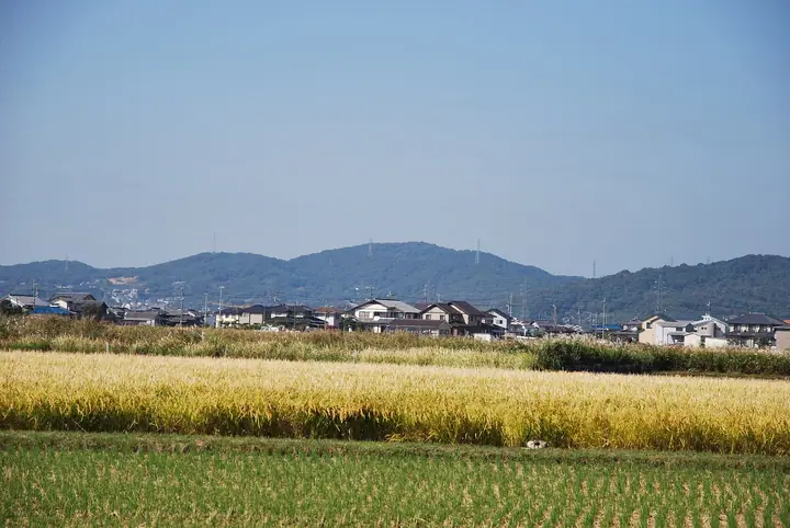
A 169-meter wooded hill stretching across the eastern part of Naka Ward in Okayama City, with about 258 hectares set aside as Misaoyama Park. Once the woodland reserve of the Edo-period Ikeda lords of Okayama Domain, the hill still serves as the borrowed scenery (shakkei) for the celebrated Korakuen garden below. Its western half is national forest designated as a natural recreation area, and the Misaoyama Park Satoyama Center at the northern foot, run by the Okayama City Parks Association, anchors a network of paths that wind among ancient burial mounds and secondary forest. The peak is included in the 100 Famous Mountains of Okayama Prefecture.
Mount Misao at a glance
- Weather: The most settled day in the next 7 days is Sun, November 8: clear, gusts up to 4 m/s.
Mount Misao weather (hourly, 14 days)
Sunrise today 06:26, sunset 17:10
| Tue, 11/3 | Wed, 11/4 | Thu, 11/5 | Fri, 11/6 | Sat, 11/7 | Sun, 11/8 | Mon, 11/9 | Tue, 11/10 | Wed, 11/11 | Thu, 11/12 | Fri, 11/13 | Sat, 11/14 | Sun, 11/15 | Mon, 11/16 | Tue, 11/17 | |||||||||||||||||||||||||||||||||||||||||||||||||||||||||||||||||||||||
|---|---|---|---|---|---|---|---|---|---|---|---|---|---|---|---|---|---|---|---|---|---|---|---|---|---|---|---|---|---|---|---|---|---|---|---|---|---|---|---|---|---|---|---|---|---|---|---|---|---|---|---|---|---|---|---|---|---|---|---|---|---|---|---|---|---|---|---|---|---|---|---|---|---|---|---|---|---|---|---|---|---|---|---|---|---|
| Japan time | 15 | 17 | 19 | 21 | 23 | 1 | 3 | 5 | 7 | 9 | 11 | 13 | 15 | 18 | 21 | 0 | 3 | 6 | 9 | 12 | 15 | 18 | 21 | 0 | 3 | 6 | 9 | 12 | 15 | 18 | 21 | 0 | 3 | 6 | 9 | 12 | 15 | 18 | 21 | 0 | 3 | 6 | 9 | 12 | 15 | 18 | 21 | 0 | 3 | 6 | 9 | 15 | 21 | 3 | 9 | 15 | 21 | 3 | 9 | 15 | 21 | 3 | 9 | 15 | 21 | 3 | 9 | 15 | 21 | 3 | 9 | 15 | 21 | 3 | 9 | 15 | 21 | 3 | 9 | 15 | 21 | 3 | 9 | 15 | |
  | |   | | | | | |   | |  | | |   |   |   |   | | |   |   | | | |   |  | | | | | | | | | | | | | | | | | | | | | | | | | | | |   | | | | | | | | | | |  | | | | | | | | | |   | | | | | | |  | | | ||
| Temperature | °C | 20° | 17° | 14° | 13° | 11° | 10° | 10° | 9° | 9° | 14° | 17° | 18° | 18° | 14° | 14° | 14° | 13° | 13° | 14° | 18° | 19° | 17° | 16° | 15° | 14° | 13° | 16° | 20° | 19° | 14° | 11° | 8° | 8° | 7° | 11° | 14° | 14° | 10° | 7° | 6° | 4° | 4° | 10° | 15° | 16° | 12° | 11° | 10° | 9° | 9° | 14° | 17° | 10° | 7° | 12° | 17° | 9° | 8° | 10° | 14° | 7° | 4° | 9° | 15° | 9° | 7° | 13° | 14° | 6° | 3° | 9° | 15° | 9° | 8° | 15° | 17° | 14° | 12° | 17° | 18° | 11° | 7° | 10° | 14° |
| Precipitation | mm | 0.7 | 0.7 | 3.2 | 1.1 | 0.2 | 1.7 | 0.8 | 0.6 | 0.2 | 0.5 | 4.5 | 2.1 | 0.3 | |||||||||||||||||||||||||||||||||||||||||||||||||||||||||||||||||||||||
| New snow | cm | ||||||||||||||||||||||||||||||||||||||||||||||||||||||||||||||||||||||||||||||||||||
| Snow depth | cm | 0 | 0 | 0 | 0 | 0 | 0 | 0 | 0 | 0 | 0 | 0 | 0 | 0 | 0 | 0 | 0 | 0 | 0 | 0 | 0 | 0 | 0 | 0 | 0 | 0 | 0 | 0 | 0 | 0 | 0 | 0 | 0 | 0 | 0 | 0 | 0 | 0 | 0 | 0 | 0 | 0 | 0 | 0 | 0 | 0 | 0 | 0 | 0 | 0 | 0 | 0 | 0 | 0 | 0 | 0 | 0 | 0 | 0 | 0 | 0 | 0 | 0 | 0 | 0 | 0 | 0 | 0 | 0 | 0 | 0 | 0 | 0 | 0 | 0 | 0 | 0 | 0 | 0 | 0 | 0 | 0 | 0 | 0 | 0 |
| Wind | m/s | 2 | 1 | 2 | 1 | 1 | 1 | 1 | 1 | 1 | 1 | 1 | 2 | 1 | 1 | 1 | 1 | 2 | 1 | 0 | 1 | 1 | 1 | 1 | 3 | 3 | 3 | 3 | 4 | 5 | 4 | 3 | 2 | 3 | 2 | 3 | 4 | 4 | 2 | 2 | 1 | 1 | 0 | 0 | 1 | 1 | 2 | 1 | 1 | 1 | 1 | 2 | 2 | 1 | 2 | 2 | 4 | 3 | 3 | 2 | 4 | 1 | 1 | 0 | 4 | 2 | 2 | 3 | 4 | 1 | 1 | 1 | 2 | 1 | 1 | 2 | 2 | 1 | 2 | 2 | 5 | 3 | 0 | 1 | 1 |
| Wind gusts | m/s | 6 | 6 | 4 | 5 | 3 | 2 | 2 | 2 | 2 | 3 | 5 | 6 | 4 | 4 | 3 | 5 | 4 | 4 | 3 | 4 | 4 | 3 | 3 | 6 | 6 | 6 | 7 | 10 | 12 | 11 | 8 | 6 | 5 | 6 | 7 | 11 | 10 | 8 | 4 | 3 | 3 | 2 | 3 | 4 | 4 | 4 | 3 | 2 | 3 | 2 | 5 | 7 | 6 | 4 | 6 | 9 | 10 | 7 | 6 | 9 | 8 | 2 | 3 | 8 | 10 | 5 | 6 | 10 | 9 | 3 | 3 | 5 | 5 | 4 | 5 | 6 | 4 | 6 | 7 | 10 | 11 | 5 | 4 | 5 |
| Wind dir. | ↓ | ↓ | ↓ | ↓ | ↓ | ↓ | ↓ | ↓ | ↓ | ↓ | ↓ | ↓ | ↓ | ↓ | ↓ | ↓ | ↓ | ↓ | ↓ | ↓ | ↓ | ↓ | ↓ | ↓ | ↓ | ↓ | ↓ | ↓ | ↓ | ↓ | ↓ | ↓ | ↓ | ↓ | ↓ | ↓ | ↓ | ↓ | ↓ | ↓ | ↓ | ↓ | ↓ | ↓ | ↓ | ↓ | ↓ | ↓ | ↓ | ↓ | ↓ | ↓ | ↓ | ↓ | ↓ | ↓ | ↓ | ↓ | ↓ | ↓ | ↓ | ↓ | ↓ | ↓ | ↓ | ↓ | ↓ | ↓ | ↓ | ↓ | ↓ | ↓ | ↓ | ↓ | ↓ | ↓ | ↓ | ↓ | ↓ | ↓ | ↓ | ↓ | ↓ | ↓ | |
Huts, campsites and lodging near Mount Misao
Lodging
- Okayama International Hotel
- SANKO-SO
- 岡山プラザホテル
- The OneFive Okayama
- ホテルエクセル岡山
Lists that include Mount Misao
Mount Misao facts
- Elevation
- 169 m
- Location
- Okayama, Okayama
34.661249, 133.955677 - Website
- www.okayama-park.or.jp
- Trail Map
- www.okayama-park.or.jp (PDF)
- Wikipedia
- ja.wikipedia.org