
Mount Mikuma
三熊山
Sumoto, Hyogo · Elevation 125 m
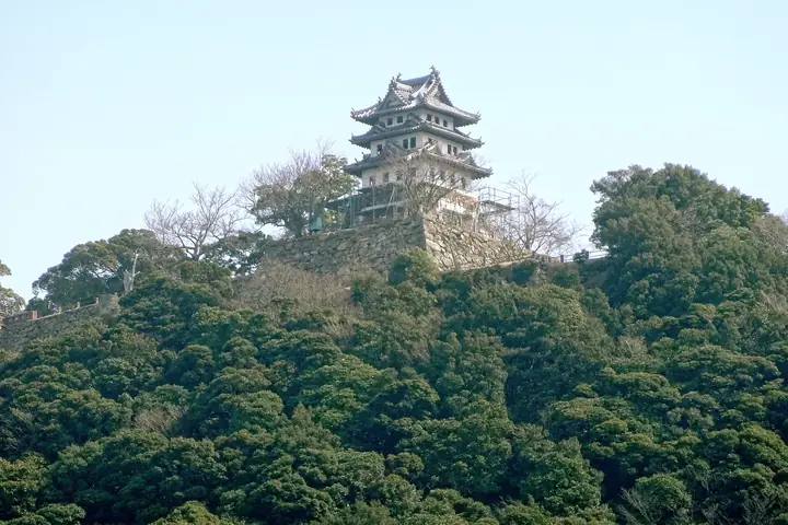
Mount Mikuma rises south of the city centre on the eastern coast of Awaji Island in Sumoto, Hyōgo Prefecture. Its summit holds the ruins of Sumoto Castle, seat of Awaji's rulers from the Sengoku through Edo periods, with stone walls still standing; the mock keep built as a lookout in 1928 is said to be Japan's oldest (currently closed to entry). The hill lies within Setonaikai National Park and overlooks the Kitan Strait. Its slopes retain primary forest with a variety of evergreen broadleaf trees.
Mount Mikuma at a glance
- Weather: The most settled day in the next 7 days is Mon, November 9: clear, gusts up to 7 m/s.
Mount Mikuma weather (hourly, 14 days)
Sunrise today 06:21, sunset 17:07
| Tue, 11/3 | Wed, 11/4 | Thu, 11/5 | Fri, 11/6 | Sat, 11/7 | Sun, 11/8 | Mon, 11/9 | Tue, 11/10 | Wed, 11/11 | Thu, 11/12 | Fri, 11/13 | Sat, 11/14 | Sun, 11/15 | Mon, 11/16 | Tue, 11/17 | |||||||||||||||||||||||||||||||||||||||||||||||||||||||||||||||||||||||
|---|---|---|---|---|---|---|---|---|---|---|---|---|---|---|---|---|---|---|---|---|---|---|---|---|---|---|---|---|---|---|---|---|---|---|---|---|---|---|---|---|---|---|---|---|---|---|---|---|---|---|---|---|---|---|---|---|---|---|---|---|---|---|---|---|---|---|---|---|---|---|---|---|---|---|---|---|---|---|---|---|---|---|---|---|---|
| Japan time | 15 | 17 | 19 | 21 | 23 | 1 | 3 | 5 | 7 | 9 | 11 | 13 | 15 | 18 | 21 | 0 | 3 | 6 | 9 | 12 | 15 | 18 | 21 | 0 | 3 | 6 | 9 | 12 | 15 | 18 | 21 | 0 | 3 | 6 | 9 | 12 | 15 | 18 | 21 | 0 | 3 | 6 | 9 | 12 | 15 | 18 | 21 | 0 | 3 | 6 | 9 | 15 | 21 | 3 | 9 | 15 | 21 | 3 | 9 | 15 | 21 | 3 | 9 | 15 | 21 | 3 | 9 | 15 | 21 | 3 | 9 | 15 | 21 | 3 | 9 | 15 | 21 | 3 | 9 | 15 | 21 | 3 | 9 | 15 | |
  |   |   | |   |  | | | | | | |   | |   |   | | |   |   |  |  |   |   | | | | | | | | | | | | | | | | | | | | | | | | | | | | | | | | | | | | |   |  | | | | |   | | | | | | | | | | | | | | |  | | | ||
| Temperature | °C | 19° | 18° | 16° | 16° | 16° | 16° | 15° | 15° | 15° | 16° | 16° | 17° | 18° | 18° | 18° | 16° | 16° | 16° | 17° | 19° | 20° | 18° | 19° | 19° | 18° | 17° | 18° | 19° | 20° | 18° | 15° | 14° | 13° | 13° | 13° | 15° | 16° | 14° | 12° | 11° | 11° | 11° | 13° | 15° | 15° | 15° | 14° | 13° | 13° | 13° | 15° | 16° | 14° | 12° | 14° | 17° | 13° | 11° | 12° | 14° | 11° | 10° | 12° | 14° | 12° | 12° | 13° | 15° | 11° | 10° | 13° | 15° | 14° | 14° | 17° | 19° | 18° | 16° | 18° | 18° | 13° | 10° | 11° | 14° |
| Precipitation | mm | 5 | 0.9 | 0.3 | 1.3 | 0.1 | 1.0 | 0.4 | 1.0 | 0.5 | 0.3 | 0.2 | 0.1 | 2.0 | 5 | 8 | 0.9 | ||||||||||||||||||||||||||||||||||||||||||||||||||||||||||||||||||||
| New snow | cm | ||||||||||||||||||||||||||||||||||||||||||||||||||||||||||||||||||||||||||||||||||||
| Snow depth | cm | 0 | 0 | 0 | 0 | 0 | 0 | 0 | 0 | 0 | 0 | 0 | 0 | 0 | 0 | 0 | 0 | 0 | 0 | 0 | 0 | 0 | 0 | 0 | 0 | 0 | 0 | 0 | 0 | 0 | 0 | 0 | 0 | 0 | 0 | 0 | 0 | 0 | 0 | 0 | 0 | 0 | 0 | 0 | 0 | 0 | 0 | 0 | 0 | 0 | 0 | 0 | 0 | 0 | 0 | 0 | 0 | 0 | 0 | 0 | 0 | 0 | 0 | 0 | 0 | 0 | 0 | 0 | 0 | 0 | 0 | 0 | 0 | 0 | 0 | 0 | 0 | 0 | 0 | 0 | 0 | 0 | 0 | 0 | 0 |
| Wind | m/s | 4 | 4 | 5 | 5 | 5 | 5 | 6 | 5 | 6 | 6 | 5 | 5 | 5 | 5 | 4 | 5 | 4 | 4 | 3 | 4 | 2 | 1 | 2 | 4 | 5 | 5 | 7 | 8 | 6 | 6 | 7 | 7 | 6 | 7 | 7 | 7 | 7 | 6 | 4 | 3 | 4 | 3 | 4 | 4 | 3 | 4 | 4 | 3 | 2 | 3 | 3 | 3 | 2 | 3 | 5 | 5 | 7 | 9 | 8 | 7 | 5 | 3 | 2 | 3 | 1 | 4 | 6 | 6 | 5 | 4 | 4 | 1 | 1 | 2 | 4 | 6 | 4 | 2 | 6 | 8 | 7 | 6 | 5 | 4 |
| Wind gusts | m/s | 8 | 8 | 8 | 8 | 8 | 8 | 9 | 9 | 9 | 10 | 10 | 9 | 8 | 8 | 8 | 7 | 8 | 7 | 6 | 7 | 6 | 4 | 4 | 8 | 8 | 10 | 12 | 13 | 13 | 11 | 12 | 13 | 12 | 11 | 13 | 13 | 12 | 11 | 10 | 7 | 6 | 6 | 7 | 9 | 8 | 7 | 7 | 6 | 5 | 5 | 6 | 7 | 6 | 5 | 9 | 10 | 12 | 14 | 14 | 14 | 12 | 9 | 6 | 7 | 6 | 8 | 10 | 13 | 11 | 9 | 8 | 8 | 5 | 4 | 6 | 10 | 11 | 9 | 11 | 12 | 13 | 11 | 9 | 9 |
| Wind dir. | ↓ | ↓ | ↓ | ↓ | ↓ | ↓ | ↓ | ↓ | ↓ | ↓ | ↓ | ↓ | ↓ | ↓ | ↓ | ↓ | ↓ | ↓ | ↓ | ↓ | ↓ | ↓ | ↓ | ↓ | ↓ | ↓ | ↓ | ↓ | ↓ | ↓ | ↓ | ↓ | ↓ | ↓ | ↓ | ↓ | ↓ | ↓ | ↓ | ↓ | ↓ | ↓ | ↓ | ↓ | ↓ | ↓ | ↓ | ↓ | ↓ | ↓ | ↓ | ↓ | ↓ | ↓ | ↓ | ↓ | ↓ | ↓ | ↓ | ↓ | ↓ | ↓ | ↓ | ↓ | ↓ | ↓ | ↓ | ↓ | ↓ | ↓ | ↓ | ↓ | ↓ | ↓ | ↓ | ↓ | ↓ | ↓ | ↓ | ↓ | ↓ | ↓ | ↓ | ↓ | |
Huts, campsites and lodging near Mount Mikuma
Lodging
- 島花
Mount Mikuma facts
- Elevation
- 125 m
- Location
- Sumoto, Hyogo
34.337718, 134.903274 - National Park
- 瀬戸内海国立公園
- Website
- www.awajishima-kanko.jp
- Wikipedia
- ja.wikipedia.org